|

Sedimentary Rocks
Are types of rock that are formed by the deposition of material at the Earth's surface and within bodies of water. Sedimentation is the collective name for processes that cause mineral and/or organic particles to settle and accumulate or minerals to precipitate from a solution. Particles that form a sedimentary rock by accumulating are called sediment. Before being deposited, sediment was formed by weathering and erosion in a source area, and then transported to the place of deposition by water, wind, ice, mass movement or glaciers which are called agents of denudation.
Example of a layered rock
The sedimentary rock cover of the continents of the Earth's crust is extensive, but the total contribution of sedimentary rocks is estimated to be only 8% of the total volume of the crust. Sedimentary rocks are only a thin veneer over a crust consisting mainly of igneous and metamorphic rocks. Sedimentary rocks are deposited in layers as strata, forming a structure called bedding. The study of sedimentary rocks and rock strata provides information about the subsurface that is useful for civil engineering, for example in the construction of roads, houses, tunnels, canals or other structures. Sedimentary rocks are also important sources of natural resources like coal, fossil fuels, drinking water or ores.
A Geological Fold
Occurs when one or a stack of originally flat and planar surfaces, such as sedimentary strata, are bent or curved as a result of permanent deformation. Synsedimentary folds are those due to slumping of sedimentary material before it is lithified. Folds in rocks vary in size from microscopic crinkles to mountain-sized folds. They occur singly as isolated folds and in extensive fold trains of different sizes, on a variety of scales.

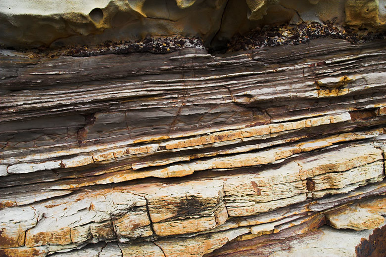
Example of a layered rock with folds.
Folds form under varied conditions of stress, orogenic tension, pore pressure, and temperature gradient, as evidenced by their presence in soft sediments, the full spectrum of metamorphic rocks, and even as primary flow structures in some igneous rocks. A set of folds distributed on a regional scale constitutes a fold belt, a common feature of orogenic zones. Folds are commonly formed by shortening of existing layers, but may also be formed as a result of displacement on a non-planar fault (fault bend fold), at the tip of a propagating fault (fault propagation fold), by differential compaction or due to the effects of a high-level igneous intrusion e.g. above a laccolith.
Weathering
In general, weathering is natural process that breaks down rocks into smaller pieces. There are two main types of weathering – mechanical and chemical. Mechanical weathering is caused by the elements of nature such as wind, water, and cold / heat. These elements physically break off pieces of rock. Chemical weathering includes various chemical reactions that break down rocks. Also, there are several important factors that affect the rate of weathering in specific environment.

Weathering is often confused with erosion, although they represent two different types of processes. Weathering occurs in place and no movement is involved in weathering. Rocks are broken down but they stay on their location. If rock fragment is moved from its location then the process is called erosion. Erosion involves movement of rock fragments by some flowing agent such as air, water or ice. So, if a rock fragment is loosened, chemically or mechanically, but stays put, it is weathering. Once the rock fragment starts moving, it is erosion.
The Earthcache
At Ground Zero you can observe a layered rocks.
To log this earthcache send us the answers of the following questions by email:
1. In the indicated coordinates says which of the schemes below best illustrates what you see (A, B, C or D).

2. Look at the whole wall. Can you identify any fold? Explain.
3. Can you see any type of weathering on the site? Justify your answer.
4. Take a photo of yourself or your nickname showing the place or the surrounding landscape (Mandatory task from July 22, 2025).
According to the January 2013 guidelines: After sending the answers by email you can log it, and upload the photo, if there is any problem we will contact you. If you do not send us the answers, or do not upload the photo, your log will be deleted.

Sedimentne Stijene
Jesu li vrste stijena nastale talozenjem materijala na Zemljinoj površini iu tijelima vode. Sedimentacija je kolektivni naziv za procese koji uzrokuju talozenje i akumulaciju mineralnih i / ili organskih čestica ili istalozenje minerala iz otopine. Čestice koje tvore sedimentnu stijenku akumuliraju se naziva sediment. Prije talozenja sediment je nastao zbog vremenskih utjecaja i erozije u izvornom području, a potom prevezen do mjesta talozenja vodom, vjetrom, ledom, masovnim pokretom ili ledenjakima koji se nazivaju agenti denudacije.
Primjer slojevite stijene
Sedimentni stjenjak kontinenta Zemljine kore je opsezan, ali ukupni doprinos sedimentnih stijena procjenjuje se na samo 8% ukupnog volumena kora. Sedimentne stijene su tek tanki furnir na kore koja se uglavnom sastoji od zilavih i metamorfnih stijena. Sedimentne stijene se nanose u slojeve kao slojevi, stvarajući strukturu zvanu posteljinu. Proučavanje sedimentnih stijena i stijenskih slojeva daje informacije o podzemlju korisnom za građevinarstvo, na primjer u izgradnji cesta, kuća, tunela, kanala ili drugih građevina. Sedimentne stijene također su vazni izvori prirodnih resursa poput ugljena, fosilnih goriva, pitke vode ili ruda.
Geološka skela
Pojavljuje se kada su jedna ili hrpa izvorno ravnih i ravnih površina, kao što su sedimentni slojevi, savijeni ili zakrivljeni zbog trajne deformacije. Sintedimentativni nabori su oni zbog usporavanja sedimentnog materijala prije nego što je litij. Preklopnice u stijenama variraju u veličini od mikroskopskih crinkles do fold-size folds. Oni se pojavljuju pojedinačno kao izolirani nabori i u opseznim nabijenim vlakovima različitih veličina, na različitim vaga.
Primjer slojevite stijene s naborima.
Presavijanje oblika pod raznim uvjetima stresa, orogene napetosti, tlaka pore i gradijenta temperature, što se očituje njihovom prisutnošću u mekim sedimentima, punim spektrom metamorfnih stijena, pa čak i primarnim struktura protoka u nekim magičnim stijenama. Skup naborova raspoređenih na regionalnoj razini predstavlja naborni pojas, zajednički sastav orogenskih zona. Preklapanja se obično formiraju skraćivanjem postojećih slojeva, ali mogu nastati kao posljedica pomaka na ne-planarnoj grešci (krug savijanja krivnje), na vrhu propagacijske greške (fold propuštanja krivulje), diferencijalnom zbijanju ili dospijećem Na učinke visokog stupnja magične upada, npr Iznad laccolita.
Ukošenje
Općenito, vremenske prilike su prirodni proces koji razbija stijene u manje komade. Postoje dvije glavne vrste vremenskih utjecaja - mehanička i kemijska. Mehaničko su vremenske prilike uzrokovane elementima prirode poput vjetra, vode i hladnoće / vrućine. Ti elementi fizički rasturaju komadiće stijena. Kemijski vremenski uvjeti uključuju različite kemijske reakcije koje razgrađuju stijene. Također, postoji nekoliko vaznih čimbenika koji utječu na brzinu vremeplova u određenom okruzenju.
Mjerenje vremena često se zbunjuje s erozijom, iako predstavljaju dvije različite vrste procesa. Mjerenje se događa na mjestu i nema kretanja zbog vremenskih utjecaja. Stijene su razbijene, ali ostaju na njihovom mjestu. Ako se stijenski fragment pomakne s njenog mjesta, proces se naziva erozijom. Erozija uključuje kretanje ulomaka stijena nekim sredstvom koje teče, kao što je zrak, voda ili led. Dakle, ako je kameni fragment labav, kemijski ili mehanički, ali ostaje stavljen, to je vremenske prilike. Kad se stijenski fragment počinje kretati, to je erozija.
Izvor: Wikipedia
Earthcache
Na Ground Zero mozete promatrati slojevite stijene.
Cijeli set pokazuje ljepotu i jedinstvene estetske detalje.
Da biste prijavili ovu Earthcachu, pošaljite nam odgovore na sljedeća pitanja:
1. U naznačenim koordinatama kaze koja od dolje prikazanih shema najbolje ilustrira ono što vidite (A, B, C ili D).
2. Pogledajte cijeli zid. Mozete li identificirati bilo koji omot? Objasniti.
3. Mozete li vidjeti bilo koju vrstu vremenskih utjecaja na web mjestu? Opravdajte svoj odgovor.
4. Fotografirajte sebe ili svoj nadimak na kojoj je prikazano mjesto ili okolni krajolik (obavezni zadatak od 22. srpnja 2025).
Prema smjernicama iz siječnja 2013: Nakon što pošaljete odgovore putem e-pošte, možete ih prijaviti i prenijeti fotografiju. Ako bude bilo kakvih problema, kontaktirat ćemo vas. Ako nam ne pošaljete odgovore ili ne prenesete fotografiju, vaš će se zapisnik izbrisati.
|