Welcome to 'Phantom Falls'
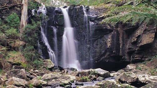
Located along the Saint George River, phantom falls is a lesser known waterfall and Geological feature in Otways National Park.
This walk involves a walk in of around 3km and at times can be wet and muddy.
Like all hiking in the bush please be well prepared with a fully charged mobile phone, appropriate clothing and water.
Getting there
Leave Allenvale Road at posted trailhead and wall along the sign posted foor trail to Phantom Falls. The trail crosses a small bridge at Saint George River, skirts an old apple orchard and rejoins the river. The trail now climbs steadily for 1.3km to a turnoff on the left. Disregard this and walk a few metres further on and turn right off the main track to a fine viewpoint overlooking Phantom Falls. Descend the steps to under the falls.
The Earthcache
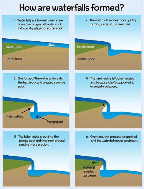
Waterfalls are commonly formed in the upper course of the river. When the river courses over resistant bedrock, erosion happens slowly and is dominated by impacts of water-borne sediment on the rock, while downstream the erosion occurs more rapidly. As the watercourse increases its velocity at the edge of the waterfall, it may pluck material from the riverbed, if the bed is fractured or otherwise more erodable. A process known as "potholing" involves local erosion of a potentially deep hole in bedrock due to turbulent whirlpools spinning stones around on the bed, drilling it out. Sand and stones carried by the watercourse therefore increase erosion capacity. This causes the waterfall to carve deeper into the bed and to recede upstream. Often over time, the waterfall will recede back to form a canyon or gorge downstream as it recedes upstream, and it will carve deeper into the ridge above it.
Often, the rock stratum just below the more resistant shelf will be of a softer type, meaning that undercutting due to splashback will occur here to form a shallow cave-like formation known as a rock shelter under and behind the waterfall. Eventually, the outcropping, more resistant cap rock will collapse under pressure to add blocks of rock to the base of the waterfall. These blocks of rock are then broken down into smaller boulders by attrition as they collide with each other, and they also erode the base of the waterfall by abrasion, creating a deep plunge pool in the gorge downstream.
 source: "Wikipedia"
Questions:
1. Can you see a plunge pool or any overhanging rock visible at these falls? Disscuss based on supplied information if so and why.
2. What is the estimated height of the falls?
3. Name three things you can see that are evidence of the above described process of rock formation.
Hope you enjoyed this EarthCache & please feel free to upload a photo too
Once you complete the Earthcache requirements you can post your find without delay, as per the guidelines. You will also need to verify your find by sending me an email providing answers to the questions. This can be through the message centre or via email linked in my profile.