Logging Requirements:
Find the four closest ponds, look on both sides of the road.
- What are evidences that these ponds are glacially formed?
- How big (width and length) are the ponds? (Imagine the size of the erratics necessary to form them!)
- Are the ponds “longer” all in the same direction? Based on your reading below about glacial striations, which way might the glacier have been moving?
- I have included a diagram (Batterson, 12) that can help you identify which flow you are viewing. Based on what you are viewing at this location, which describes the flow you see striations from based on the direction of the striations?
a. Late Wisconsinan radial and recessional flow (west and south west)
b. Wisconsinan southern flow
c. Pre-Wisconsinan onshore westward flow
What you are looking at as you travel across the “barren landscape” of the Burin Peninsula (Byorn) is the result of millennia of glacial activity that has scraped the bedrock of the peninsula. Scientists have come to different conclusions about how far the glaciation spread, (just to the area near hwy 210 or covering the whole peninsula). As late as 1988, in fact, scientists believed that glaciation had not affected the peninsula. However, most now believe that glaciers have been a recent part of the topography, largely based on observations much like those you are making from the posted coordinates.
Now, let’s define striation - According to Wikipedia, glacial striations are “scratches or gouges cut into bedrock by glacial abrasion. These scratches and gouges were first recognized as the result of a moving glacier in the late 18th century when Swiss alpinists first associated them with moving glaciers.
“Striations are excellent indicators of ice flow as they are formed by the direct action of moving ice on bedrock.” This is possible by making various observations from several locations (for example see waypoint #2) about the orientation of the ponds you see on the bedrock before you. (Batterson, 3). Notice that the ponds are not eroded, nor are they typically connected. This demonstrates that the glacial action took place more recently than other geologic events that affected the area.
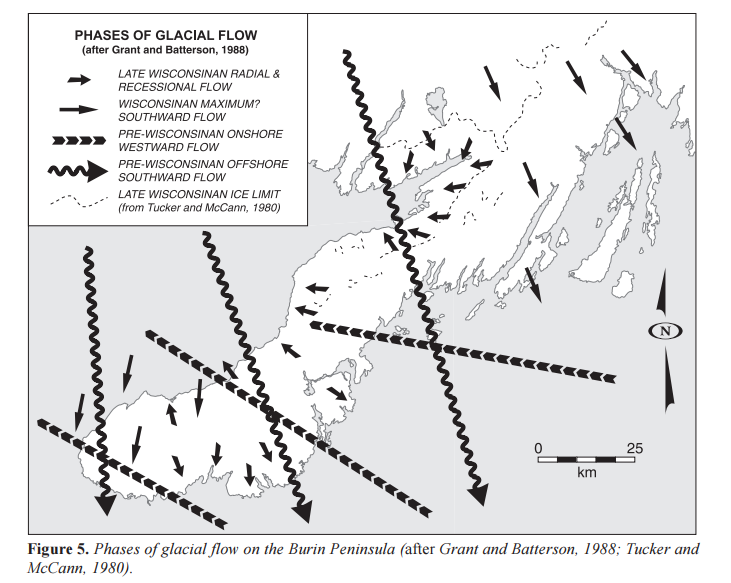
You may also notice that the striations do NOT have any moraines (stacks of rocks) piled nearby. This means that ice was over this area consistently without a “break.” For this reason, geologists say that the striations you see before you happened during the late Wisconsin as one of three flow events each distinct and moving in a separate direction (Batterson, 5-6). The first flow moves south, the second west, and the third west to southwest. In some areas on the Burin peninsula, geologists state that you can identify all three events in the same exposure of bedrock Unfortunately those locations aren’t easy to access.
Reference:
Batterson, M. J., and D. M. Taylor. "Natural Resources TILL GEOCHEMISTRY OF THE BURIN PENINSULA, NEWFOUNDLAND." Newfoundland and Labrador. Department of Natural Resources, May 2009. Web. 16 July 2017.
"Glacial Striation." Wikipedia. Wikimedia Foundation, 02 July 2017. Web. 16 July 2017.