Within the quarry there is a nearly vertical face, 10m high by about 40m long, which is an exposed horizontal fault plane. Although faults are commonly recognised by geologists and shown frequently on geological maps they are rarely seen as clearly. The fault plane is oriented in a SW-NE direction and forms the southern face of the main quarry. The fault plane cuts across shallow-dipping Precambrian ABC Range Quarzite.
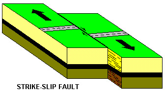
The fault plane shows polished rock surfaces bearing fine horizontal scratches, known as slickensides. These markings indicate that the two blocks of rock dislocated by the fault have moved laterally against one another. This fact makes the fault additionally interesting, as it is an unusual fault type, called transcurrent or strike-slip. The most famous fault of this type is the notorious San Andreas fault in California.
The quartzite from the quarry is a dense, hard rock, off-white to pink in colour. Quarrying was abandoned when shattered rock was encountered within 2m of the fault. The fault plane face is stained yellow-brown where iron oxides have circulated through joints in the shattered rock.
At the request of the SA Division of the Geological Society of Australia the District Council of Crystal Brook-Redhill agreed in 1990 to protect the site. As at March 1994 the Council has provided clear access to this part of the quarry known as Stone Reserve. The parking waypoint is at the public access gate. Take care as you are entering a quarry.
Standing at the base of the quarry the fault plane is directly south. Compare the disturbed rock of the fault face with the quarzite zone to the west. The quarry did not extend into fault because of the change in condition of the rock.
-Describe the diffence between the fault plane rock and the quarried quartzite.
-Can you seen any evidence of slickensides? The west side of the face is a good place to check.
-Whose fault was it?