This challenge cache is intended to inspire you to get out and look for caches in more varied terrain, and try some of the tougher puzzles. To log this cache, you must have found at least
* * * 40 different difficulty/ terrain combinations * * *.
When a cache owner lists a new cache, they give it a rating for the difficulty of finding the cache, and another for the terrain you need to cover to get there.There are 9 possible difficulty levels, and 9 different terrain ratings, so there are 81 possible combinations. You only need to find 40 different combinations for this challenge.
You can view your D/T grid to see how many different combinations you have already found. Click on your profile name at the top of any page on geocaching.com, then choose "profile" and then "statistics". Scroll down to see your D/T grid. When you log this cache, you need to use the challenge checker (link is below) to confirm that you qualify.
The rules.
1. You may sign the log at any time, but you may not log as "found" until you have completed the challenge requirements. In the meantime, you may post a note to say you found the cache and signed the log book.
2. The cache is at the listed co-ordinates. We don't intend it to be difficult to find, so see below for help on finding it.
3. The challenge checker will confirm that you have completed the requirements, with a green tick. It can take a few days to update recent finds, so if you think you have recently completed the requirements and it didn't work, try again in a day or two.
4. You must find caches that fill at least 40 of the 81 possible combinations. Each cache must have a unique and different combination of difficulty and terrain. For example, D1T1, D1.5T1, D2T1 each count as one. Any 40 boxes satisfy the requirement, as long as your grid is half-filled.
5. Please don't ask for favours or special treatment. The challenge is the same for everybody. We have given it a difficulty rating of 5 because we know this is a hard challenge in Malaysia. You will probably have to search for caches that fill empty spaces, and you might have to travel. When the challenge was set, there were enough caches in the area to complete the challenge, but that might not always be the case. Or perhaps in the future, there will be even more caches to help you fill your grid. Visiting tourists may be rubbing their hands together in glee because you have already qualified for the challenge. For Malaysian cachers, the hardest part of the challenge will be finding 40 different D/T combinations that they can get to, but the hardest part of your challenge may well be finding your way to Bukit Kiara without a vehicle, and surviving the equatorial heat and humidity while making your way up the hill to find the cache!

Finding The Cache
The cache is near to one of the walking tracks on Bukit Kiara. Bukit Kiara is an oasis of quiet and relaxation in the midst of the hustle and bustle of Kuala Lumpur. In this fairly small nature researve, you can see many species of plants and animals, bubbling creeks and waterfalls, use the exercise equipment dotted around the main path or just enjoy a strenous walk around the pretty hillside. You can explore the many tracks that weave through the rainforest on foot or bicycle, and the overhanging trees keep the trails shady most of the time. Though you will still be battling the equatorial heat, you will probably notice that the air is a little cooler and fresher in amongst the green giants.p>
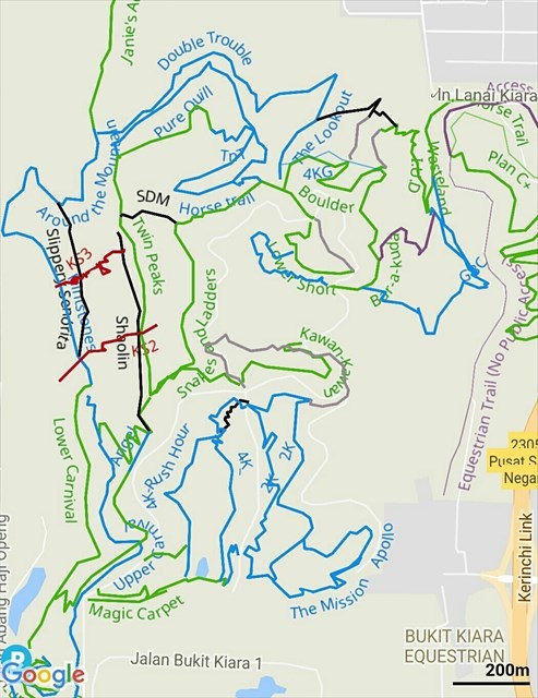
The tracks here are varied and range from wide, well-maintained sealed roads, to steep and rocky downhill mountain bike trails. As taking the wrong path can vary the terrain significantly (and significantly increase the length of your journey), and as we want you to be able to find the cache fairly easily, we have provided a map below. There are also two spoiler photos below, as GPS is often not very accurate with heavy tree cover. Regardless of the route you take, you will be going uphill to get up to this cache, and there will probably be steep sections. Depending on which path you choose and your skill level, you should be able to cycle all or most of the way to the cache (though, remember, I did say parts of the journey will be steep, and the trails marked blue and black can be difficult with a bicycle, even if walking). You might appreciate the bicycle on the return journey though!
Allow an hour and a half for the return trip, as a rough estimate of average time needed, though many will choose to look for other caches on the hill while they are here. You may be disappointed to discover that each of the caches on the hill is on a separate trail and therefore you will need to wind around the hill, back and forth on trails, to pick up various caches. You will need to leave a number of hours free (probably at least 3, depending on how quickly you find the correct trails and the hides, and how much you plan to cover) if you wish to do this. Also remember that it rains most afternoons in Malaysia!
We recommend you use a trail map. Your geocaching app may display the trails, but sometimes the maps only display the main (sealed) track. You can install the free Trailforks app on your smartphone (which has good detail of the trails and will allow you to track where you are), or use the screenshot from Trailforks below. With the map, you can choose the best way to the cache (green are the easiest, red and black are the hardest trails).