Credit River Shale
The area from River Road to Willow Park, which is the focus of this Earthcache, is in the South Slope physiographic region characterized by low-lying ground moraines. Soils of this region tend to be clay loams with pore sizes between soil particles so small that flow of groundwater to aquifers is slow. At the north end of this site, Queenston shale bedrock is exposed in the valley Walls.
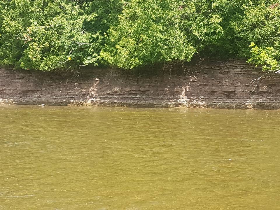
The Credit River winds across this natural area in a deeply incised valley. Valley walls are steep and exhibit some terracing. The river is wide and shallow, with a corresponding floodplain. Several small rivulets flow into the Credit River down the valley banks. Most of this area falls into two adjoining main Credit River subwatersheds. At the southeast end of this area, Silver Creek joins the main Credit River, at Willow Park in Norval. As such, the southern tip of this area is in the Silver Creek subwatershed.
Shale is a fine-grained sedimentary rock that forms from the compaction of silt and clay-size mineral particles that we commonly call mud. This composition places shale in a category of sedimentary rocks known as mudstones. Shale is distinguished from other mudstones because it is fissile and laminated. Laminated means that the rock is made up of many thin layers. Fissile means that the rock readily splits into thin pieces along the laminations.
Shale is easily eroded or worn away. When shale weathers, they form clays or muds. Water (rain and river currents) along with wind are the major factors contributing to the continued erosion of the shale along the steep cliff walls that you see along this section of the Credit River.
The best exposures are found beneath ledges of harder more resistant rocks such as limestone and sandstones. Most shale are soft enough to be cut with a knife and can be very brittle. Shale and clay make up about 80% of the sedimentary rocks of the Earth's crust.
The process in the rock cycle which forms shale is called compaction. The fine particles that compose shale can remain suspended in water long after the larger particles of sand have deposited. Shales are typically deposited in very slow moving water and are often found in lakes and lagoonal deposits, in river deltas, on floodplains and offshore from beach sands. They can also be deposited in sedimentary basins and on the continental shelf, in relatively deep, quiet water.
Splitting shale with a large knife to reveal fossils
Fossils, animal tracks/burrows and even raindrop impact craters are sometimes preserved on shale bedding surfaces. Shales may also contain concretions consisting of pyrite, apatite, or various carbonate minerals.
Shales that are subject to heat and pressure of metamorphism alter into a hard, fissile, metamorphic rock known as slate. With continued increase in metamorphic grade the sequence is phyllite, then schist and finally to gneiss.
The wall of shale at the location of this Earthcache is over 100m long. and you will pass by a number of other walls of shale during your journey.
Recommended access points and mandatory exit point are indicated in the additional waypoints of this Earthcache listing. It is recommended that you use a river tube for your journey to complete this Earthcache. The river is also shallow enough in most parts that you could walk it. Kayaking and Canoeing are not recommended and may prove very difficult. You will be travelling a distance of 5.5km along the Credit River and will take 3 to 4 hours. Because of the dams at both ends of this section, you normally should not encounter any crazy water conditions. Be safe and bring a buddy.
To log this Earthcache, please perform the following observations and tasks and send me your results.
1) Estimate the height at the highest point for the wall of shale.
2) How many horizontal layers of shale do you see here, from the water level to the top?
3) How thick is the thickest layer of shale and approximately how far above the river is this thickest layer?
4) What colours are present in the various layers of shale and what percentages in total of each colour (total should be 100%) along this section?
5) Beware of falling shale. We witnessed the shale fall without any human interaction. Did you notice any shale fall into the river too? Is there evidence of fallen shale here in the river, if yes, what and if not, why not?
6) Does the wall of shale continue down under the water and is it different than the shale about the water?
7) How secure is the shale on the wall? What do you think will happen to this wall of shale in 10, 100, 1000 years?
8) As you continue your float along the Credit River to Norval, how many other significant (20m+ long) walls of shale do you pass and what side of the river are they on (your right or left) as you journey down the river?