
Cette petite commune de Saône et Loire fût jadis le terrain de jeu privilégié de mes vacances d’été chez « Papy & Mamy ». Il y a maintenant quelques années, ces grands-parents s’en sont partis, l’un après l’autre, se reposer et rejoindre les étoiles pour briller chaque nuit…
A la fois poseur et bien évidemment chercheur de géocaches dans ma région, je souhaitais leur faire un petit clin d’œil d’en bas… Ne pouvant assurer des maintenances rapides sur place, je me suis tourné vers l’earthcache ; celle-ci est d’ailleurs ma première.
Je vous souhaite de prendre autant de plaisir dans cette découverte que j’en ai eu, tous les jours passés avec eux.
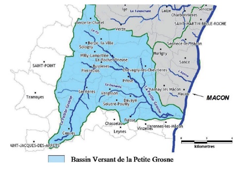
Je vous propose ici un focus sur le réseau hydrographique du bassin versant de la Petite Grosne, appartenant plus largement au bassin Rhône-Méditerranée-Corse. Ce bassin se situe dans l’ouest mâconnais, au sud du département de Saône-et-Loire. Il traverse 14 communes de Saône-et-Loire et une commune du Rhône, Cenves (altitude 555 mètres), d’où la Petite Grosne prend sa source. Elle s’étend sur 25,6 kilomètres pour se jeter dans la Saône à Macon-sud.
Au sein des Monts du Mâconnais, il comprend trois principaux cours d’eau :
• la Petite Grosne qui conflue sur la commune de Mâcon en rive droite de la Saône
• la Denante, 1er affluent
• le fil, second affluent qui se jette dans la petite Grosne à Prissé
A noter qu’un peu moins de la moitié de ce bassin est exploité en zones viticoles.
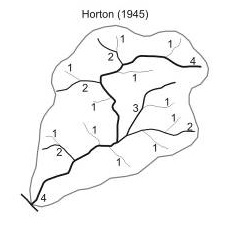
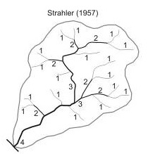
Pour mesurer l’importance d’un cours d’eau et de ses ramifications hydrographiques, la méthode la plus communément utilisée est appelée LE NOMBRE DE STRAHLER, et remonte à 1957.
Préalablement, en 1945, Robert E. Horton a présenté une technique d’ordination des cours d’eau inspirée, lui-même, des idées de l’hydrologue allemand Gravelius (1914). L’objectif étant de hiérarchiser les différents segments du réseau hydrographique d’un bassin versant étudié. Le cours d’eau principal du bassin versant reçoit le numéro d’ordre « 1 » depuis son exutoire jusqu’à sa source ; Il en est ainsi pour les affluents etc… Horton a choisi d’inverser cette ordination, en donnant le numéro d’ordre « 1 » aux sources et en augmentant la valeur en direction du tronc hydrographique principal.
C’est sur ces bases qu’ensuite qu’Arthur Newell Strahler, en 1957, a développé son propre système d’ordination, en adoptant comme unité hydrographique : le tronçon. La méthode proposée attribue la valeur « 1 » à tous les tronçons de tête de bassin ; la rencontre de deux tronçons de valeur « 1 » produit, après leur confluence, un tronçon de valeur « 2 » ; la rencontre de deux tronçons de valeur « 2 » produit un tronçon de valeur « 3 », etc…
Pour valider cette earthcache, il vous suffira de répondre aux questions suivantes :
Q1/ Quel est le rang de Strahler de la petite Grosne ?
Q2/ Quelle est la largeur (à 1 mètres près) de la Petite Grosne au point suivant : N 46°19.315 E 004°44.800
Q3/ Optionnel : Une photo de vous ou de votre GPS avec en fond le lavoir serait apprécié, afin de voir l'évolution au fil des saisons. Mais cela n'est pas obligatoire
Voila, il ne vous restera qu’à loguer cette earthcache en "Found it" sans oublier de m’envoyer vos propositions de réponses soit via mon profil, soit via le Message Center. Je vous contacterai en cas de problème.
----------------------------------------------------------------------------------------------------------------------------------------------------
Source :
Wikipédia
DIREN BOURGOGNE - Atlas des zones inondables de la Petite Grosne et ses affluents – Rapport d’études - Egiseau Nov 2009
PROTECTION DE CAPTAGES - Le Creusot - 19 février 2015 - Table ronde : quatre situations locales à la loupe - www.alterre-bourgogne.org
http://theses.univ-lyon2.fr/documents/getpart.php?id=lyon2.2008.meurer_m&part=151461
---------------------------------------------------------------------------------------------------------------------------------------------------

This small town of Saone and Loire was once the privileged playground of my summer holidays at "Papy & Mamy". A few years ago, these grandparents left, one after the other, to rest and join the stars to shine each night ...
As both a poser and of course geocaching researcher in my region, I wanted to give them a little wink from below ... I could not ensure quick maintenance on site, I turned to the earthcache; this one is also my first.
I wish you to take as much pleasure in this discovery as I had, every day spent with them.
I propose here a focus on the hydrographic network of the Petite Grosne watershed, belonging more widely to the Rhone-Mediterranean-Corsica basin. This basin is located in the west of Mâconnais, south of the department of Saône-et-Loire. It crosses 14 towns of Saone-et-Loire and a commune of the Rhone, Cenves (555 meters height), from where the Little Grosne takes its source. It stretches for 25.6 kilometers to throw itself into the Saône at Macon-sud.
Within the Mâconnais Mountains, it includes three main rivers:
• Petite Grosne, which converges on the commune of Mâcon on the right bank of the Saône
• the Denante, 1st tributary
• the thread, the second tributary that flows into the small Grosne à Prissé
It should be noted that a little less than half of this basin is exploited in viticultural zones.
To measure the importance of a stream and its hydrographic ramifications, the most commonly used method is called THE NUMBER OF STRAHLER, and dates back to 1957.
Previously, in 1945, Robert E. Horton presented a technique of ordination of water courses inspired, himself, ideas of the German hydrologist Gravelius (1914). The objective is to prioritize the different segments of the hydrographic network of a studied watershed. The main watercourse of the watershed receives the order number "1" from its outlet to its source; This is the case for tributaries, etc. Horton has chosen to reverse this ordination, giving the order number "1" to the sources and increasing the value towards the main hydrographic trunk.
It was on this basis that Arthur Newell Strahler, in 1957, developed his own ordination system, adopting as a hydrographic unit: the section. The proposed method attributes the value "1" to all head sections of the basin; the meeting of two sections of value "1" produces, after their confluence, a section of value "2"; the meeting of two sections of value "2" produces a section of value "3", etc.
To validate this earthcache, all you need to do is answer the following questions:
Q1 / What is Strahler's rank of Little Grosne?
Q2 / What is the width (within 1 meter) of Petite Grosne at the following points: • N 46 ° 19.315 E 004 ° 44.800
Q3 / Optional: A photo of you or your GPS with the laundry in the background would be appreciated, to see the evolution over the seasons. But this is not required
You only have to log this earthcache in "Found it" without forgetting to send me your proposed answers either via my profile or via the Message Center. I will contact you if there is a problem.
------------------------------------------------------------------------------------------------------------------------------------------------------
Source :
Wikipédia
DIREN BOURGOGNE - Atlas des zones inondables de la Petite Grosne et ses affluents – Rapport d’études - Egiseau Nov 2009
PROTECTION DE CAPTAGES - Le Creusot - 19 février 2015 - Table ronde : quatre situations locales à la loupe - www.alterre-bourgogne.org
http://theses.univ-lyon2.fr/documents/getpart.php?id=lyon2.2008.meurer_m&part=151461
-----------------------------------------------------------------------------------------------------------------------------------------------------