To get to this cache you will need a 4x4 or be in for an approximate 7k return rough walk. Then a bit of rock hopping to get to GZ.
After heavy rain it will require a GOOD 4x4 with recovery gear and quite a bit of rock scrambling to get the last 70mts to GZ other times it will just be a bit of rock hopping.
Important
Be sure you shut the gate before you proceed as there is grazing stock on this land.
History
Between the Early and Mid - Cretaceous period, 145 to 66 million years ago, the climate, all over the world, became warmer by as much as 17° C. The ice caps at the North and South poles melted and became smaller and, of course the water released raised the sea levels all around the globe. Australia had been beginning to break away from Antarctica but, where before it had been more or less one large land-mass, now the water flowed into shallow seas in the centre of the continent.
During this period the land that was to become Australia was hot and basically broken up into a number of landmasses separated by a great shallow sea. The glaciers had melted and the seas had risen accordingly creating a hot humid existence. There was also plenty of water in rivers and a vast array of tropical vegetation. During this time layers of sediments were laid down which were later metamorphosed and deformed by the shifting land masses.
Geology
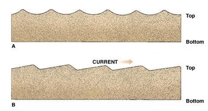
Ripple marks usually form in conditions with flowing water, in the lower part of the Lower Flow Regime. There are two types of ripple marks:
Symmetrical ripple marks:- Often found on beaches, they are created by a two way current, for example the waves on a beach (swash and backwash). This creates ripple marks with pointed crests and rounded troughs, which aren't inclined more to a certain direction. Three common sedimentary structures that are created by these processes are herringbone cross-stratification, flaser bedding, and interference ripples. Figure A
Asymmetrical ripple marks:- These are created by a one way current, for example in a river, or the wind in a desert. This creates ripple marks with still pointed crests and rounded troughs, but which are inclined more strongly in the direction of the current. For this reason, they can be used as palaeocurrent indicators. Figure B
To Get to GZ.
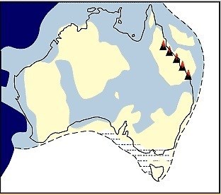
Turn off the Highway at S20° 43.084 E139° 33.901 (Remember to shut the Gate)
Take the LEFT track across the creek and turn right at S20° 43.075 E139° 34.245 now follow the track to the car park near GZ
To claim this Earth cache
At GZ you will see an excellent example of ripples formed by water movement over soft sediments.
Here you must carefully study the ripples and answer these questions:-
Q1/.. The name of this Earth Cache
Q2/.. Tell us if they are Symmetrical or Asymmetrical and what that tells you about how they were formed.
Q3/.. Obviously these sediments were laid down in a horizontal plain. Estimate what angle these ripples are sitting on today and explain why you think they are like this.
Q4/.. Feel the texture of the ripples and tell us what they feel like and also what colour the ripples are.
As a bonus
There is another cache near here Longfellow Serenade dedicated to the Aboriginal Paintings that are at S20° 43.287 E139° 35.714 Continue down stream until you get to what would be a waterfall and look around, especially to your left
Australian Aboriginal art is the oldest living art tradition in the world, The Kalkadoon artists were one of only a few aboriginal races that used dots in their rock art as well as lines and symbols. Some rock art sites in Kalkadoon country being carbon dated at over 17,500 years old.
Most Of All We Hope You Enjoy Your Visit.