Seki castle faced the Daiho swamp on the three sides (east side, south side, west side), the north side built the foundation.
As a result, attacks by the northern government were extremely difficult.
To overcome this, the army of Morofuyu Kouno (northern government) began digging the tunnel from the northeastern part of the castle toward the castle.
In response to this, castle soldiers also digged out.
However, the tunnel which the military of Morofuyu Kouno dug fall down because the ground was weak.
Therefore, it is said that the tunnel battle was canceled.
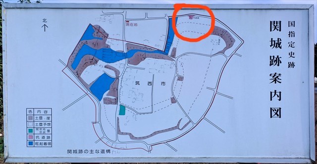
Fig-1: Map
Traces of the tunnel at that time were discovered in September 1999.
The tunnel was made in an arch shape with a width of 1 meter and a height of 2 meters.

Fig-2: Trace of Tunnel
This is an important thing in the history of war in Japan, it is said to be one of three major tunnel battle in Japan.
Currently you can see the entrance part of the tunnel.
The final coordinates of the cache are calculated based on the number written on the bulletin board at the trace of the tunnel.
How to obtain cache coordinates:
Final coordinate N 36 ° 13.6 VX 'E 139 ° 57.8 YZ' is calculated using the number AB on the lower right of the explanation board.
Fig-3: Explanation Board
V = 2 * A + B
X = 2 * B - 2 * A
Y = B + A
Z = B - A
Cache size is micro.
Please bring your pen.
----- Japanese
南北朝時代、北朝側の高師冬は、関城の物見櫓を攻め落とすために、抗夫を募って地下道を掘った跡です。
関城は三方(東側、南側、西側)を大宝沼に面しており、北側は土塁を構築して要塞化していました。
攻略が難しく北朝側の攻撃は難航を極めました。
これを打開するために、北朝の高師冬(こうのもろふゆ)勢が城の東北部から城に向かって坑道を掘り始めました。
これに応じ城兵も外に向かって掘り進みました。
しかし、高師冬勢の坑道は地盤が軟弱だったために落盤したこともあり、坑道戦は中止したと言われています。
そのときの坑道跡が、大正9年9月に発見されました。
幅1メートル、高さ2メートルほどのアーチ型の坑道です。
日本の戦史上重要なものであり、日本三大坑道の一つと言われています。
現在、坑道跡は入り口部分を見ることができます。
キャッシュの最終座標は、坑道跡にある掲示板に書かれている数字を元に計算します。
キャッシュ座標の求め方:
ファイナルの座標 N 36°13.6VX' E 139°57.8YZ' は説明看板の右下の数字ABを用いて計算します。
Fig-3: Explanation Board
V = 2 * A + B
X = 2 * B - 2 * A
Y = B + A
Z = B - A
大きさはマイクロです。
ペンをお持ちください。
参考:
筑西市ホームページ
http://www.city.chikusei.lg.jp/page/page000268.html
国立国会図書館デジタルコレクション
常総鉄道名勝案内 常総鉄道株式会社編 大正2年 P59
日本史蹟大系. 第7巻 熊田葦城 著 平凡社 1935-1936 P3139-3142