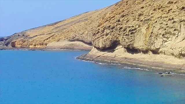
Montaña Amarilla

Montaña Amarilla es uno de los lugares emblemáticos de La Graciosa y de Canarias. Su color se debe al tipo de erupción que originó este volcán, en el que el magma se mezcló con el agua del mar. Las pintorescas formaciones rocosas en superficie continúan bajo el agua creando paisajes característicos de los fondos del Archipiélago Chinijo.
Para toda persona que visite La Graciosa, la ruta a Montaña Amarilla es una de las que no se puede perder.
Montaña Amarilla constituye el único edificio de La Graciosa configurado de forma casi completa por depósitos palagonitizados de rasgos marcadamente hidromagmáticos*, con abundantes estructuras piroclásticas asociadas a mecanismos eruptivos de carácter surtseyano. Hacia techo de la secuencia los materiales hidromagmáticos están coronados por productos volcánicos de tipo estromboliano con depósitos de caída y emisión de lavas hacia el norte.
* Erupción hidromagmática: Fenómenos eruptivos que se originan por la interacción del magma con agua superficial o subterránea. Están caracterizados por su extrema violencia, por la variedad de depósitos que originan y por la morfología de los edificios que forman.
La actividad de Montaña Amarilla comienza entre los 10.000 y los 30.000 años sobre una plataforma cubierta por un depósito marino de edad cercana a los 43.000 años. Presenta una primera fase hidromagmática, que constituye la mayor parte del edificio y de la cual recibe su nombre. Su morfología se corresponde con un anillo de tobas, en parte destruido por el mar y en parte cubierto por la fase estromboliana final. Hacia el sector suroccidental de Montaña Amarilla, los depósitos piroclásticos parecen acomodarse a un relieve preexistente, como lo indican su dirección e inclinación variables. En el acantilado se aprecia que los depósitos hidromagmáticos procedentes de Montaña Amarilla se disponen cubriendo otros depósitos hidromagmáticos de un centro eruptivo situado al SO del edificio principal. Por ello, creemos que Montaña Amarilla debe ser un edificio hidrovolcánico doble, cuyo primer centro (y menor) fue totalmente recubierto por el segundo y mayor.
El centro de emisión piroclástico está constituido por tres niveles: Tobas hidromagmáticas de tipo oleadas basales húmedas de unos 125m de espesor, tobas hidromagmáticas de tipo oleada basales secas de unos 15m de espesor y escorias, bombas y lapilli de caída de unos 20m de espesor. El hecho de que los depósitos de oleadas basales húmedas queden bien expuestos al sur del edificio, entre la playa de la Cocina y la Punta del Pobre, ha podido ser favorecido, aparte de por la abrasión marina, por el deslizamiento de los piroclastos de caída superiores a favor del plano inclinado generado en el depósito de las propias tobas hidromagmáticas.
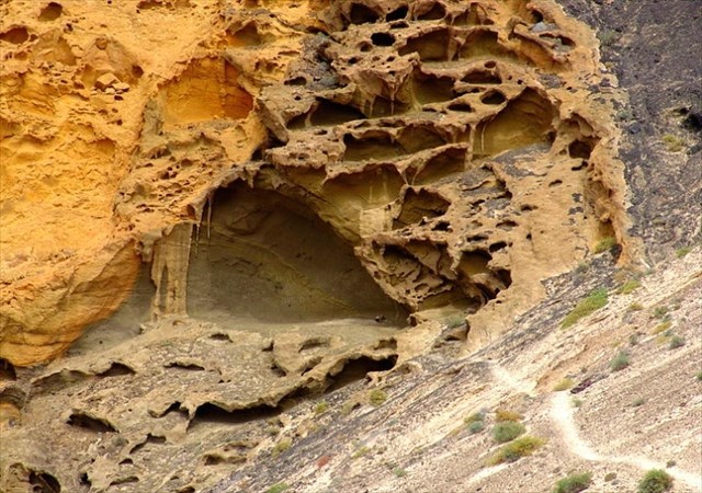
Los piroclastos hidromagmáticos de composición basáltica suelen ser emitidos como fragmentos vítreos de color marrón o gris, pero con rapidez se exponen a la meteorización (hidratación y oxidación), alterándose a vidrios de color amarillo o anaranjado, denominados genéricamente vidrios palagonitizados, típicos de erupciones hidromagmáticas.
La presencia de un nivel de playa fósil entre ambos, así como el desmantelamiento del edificio hidromagmático y la exposición de su sistema de alimentación magmática sobre el que se apoyan directamente las coladas de lava, ponen de manifiesto su construcción en dos etapas eruptivas separadas por un hiato temporal de calma.
Existen también importantes procesos de alveolización de los materiales volcánicos siguiendo la disposición de las capas, con abundantes taffonis con estructura en panal.
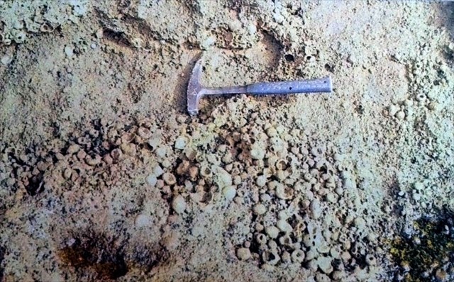
Las estructuras volcano-sedimentarias que se pueden observar son espectaculares, tanto desde el punto de vista volcánico y geomorfológico, como paisajístico. Entre ellas sobresalen no sólo el mejor ejemplo de slumps de toda Canarias, sino también la presencia de estructuras esféricas con diámetros superiores a 1 dm, mostrando tamaños no descritos en la bibliografía especializada que corresponden con lapillis acrecionales; los de mayor envergadura de los existentes en el archipiélago.
Para poder registrar como encontrado este earth, nos tenéis que mandar un correo (podéis hacerlo desde nuestro perfil de usuario) con las respuestas a las siguientes preguntas. Podéis loguear el earth sin haber recibido nuestra respuesta pero si no recibimos el correo con las respuestas correctas, el log podrá ser borrado sin previo aviso.
A) Que es la "palagonita" y la "palagonitización"? Describelas con tus palabras.
B) Desde el waypoint 1, qué colores puedes ver en la Montaña Amarilla?
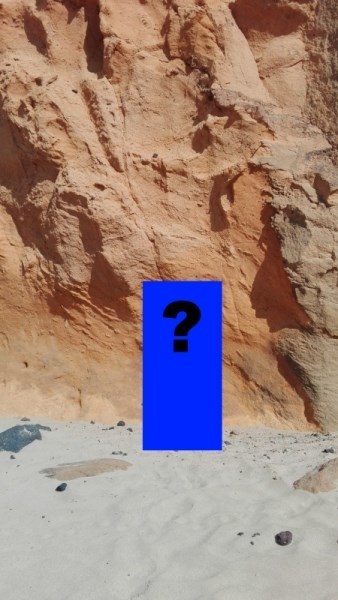
C) Acercate al waypoint 2 y dime qué puedes ver en la pared de la montaña a 1m del suelo aproximadamente (ver foto spoiler, hay mala señal GPS):
- Planta
- Roca negra
- Imagen de una virgen
- Flotador salvavidas (SOS)
D) Toca la montaña amarilla y describe con tus palabras cómo es al tacto.
E) OPCIONAL: Colgad en vuestro log una fotografía donde aparezcáis vosotros y/o vuestro GPS en las coordenadas iniciales dónde se vea la arena de la playa, el agua del oceano y un trozo de la Montaña Amarilla.
Por favor, sed respetuosos y no alteréis el entorno.
Gracias por vuestra comprensión y esperemos que disfrutéis del lugar

ENGLISH VERSION (PROVISIONALLY GOOGLE TRANSLATE)
Montaña Amarilla (ENG)
Montaña Amarilla is one of the emblematic places of La Graciosa and Canary Islands. Its color is due to the type of eruption that originated this volcano, in which the magma mixed with the sea water. The picturesque rock formations on the surface continue under the water, creating landscapes characteristic of the Chinijo Archipelago.
For anyone who visits La Graciosa, the route to Montaña Amarilla is one that you can not miss.
Montaña Amarilla is the only building in La Graciosa that is almost completely configured by palagonitized deposits with markedly hydromagmatic* features, with abundant pyroclastic structures associated with eruptive mechanisms of Surtseyan character. Towards the top of the sequence hydromagmatic materials are crowned by strombolian volcanic products with deposits of fall and emission of lava towards the north.
* Hydromagmatic eruption: Eruptive phenomena that are caused by the interaction of magma with surface or underground water. They are characterized by extreme violence, by the variety of deposits they cause and by the morphology of the buildings they form.
The activity of Montaña Amarilla begins between 10,000 and 30,000 years on a platform covered by a marine deposit of age close to 43,000 years. It presents a first hydromagmatic phase, which constitutes most of the building and from which it receives its name. Its morphology corresponds to a ring of tuffs, partly destroyed by the sea and partly covered by the final Strombolian phase. Towards the southwestern sector of Montaña Amarilla, the pyroclastic deposits seem to accommodate a pre-existing relief, as indicated by its variable direction and inclination. In the cliff it is observed that hydromagmatic deposits from Montaña Amarilla are arranged covering other hydromagmatic deposits of an eruptive center located SW of the main building. Therefore, we believe that Montaña Amarilla should be a double hydrovolcanic building, whose first center (and smaller) was completely covered by the second and larger.
The center of pyroclastic emission is constituted by three levels: hydromagmatic tobas of humid basal waves of about 125m of thickness, hydromagmatic tuffs of basal dry waves of about 15m of thickness and slag, pumps and lapilli of fall of about 20m of thickness. The fact that the deposits of humid basal waves remain well exposed to the south of the building, between the beach of La Cocina and the Punta del Pobre, could have been favored, apart from by the marine abrasion, by the sliding of the falling pyroclastics in favor of the inclined plane generated in the deposit of the hydromagmatic tuffs themselves.
The hydromagmatic pyroclastics of basaltic composition are usually emitted as glass fragments of brown or gray, but are quickly exposed to weathering (hydration and oxidation), altering to yellow or orange glasses, generically called palagonized glass, typical of hydromagmatic eruptions.
The presence of a fossil beach level between both, as well as the dismantling of the hydromagmatic building and the exposure of its magmatic feeding system on which the lava flows are directly supported, reveal its construction in two eruptive stages separated by a temporary hiatus of calm.
There are also important alveolization processes of the volcanic materials following the arrangement of the layers, with abundant taffonis with honeycomb structure.
The volcano-sedimentary structures that can be observed are spectacular, both from the volcanic and geomorphological point of view, and landscape. Among them stand out not only the best example of slumps in the Canary Islands, but also the presence of spherical structures with diameters greater than 1 dm, showing sizes not described in the specialized literature that correspond to accretionary lapillis; those of greater size than those that exist in the archipelago.
In order to register as found this earth, you have to send us an email (you can do it from our user profile) with the answers to the following questions. You can log the earth without having received our answer but if we do not receive the email with the correct answers, the log can be deleted without previous warning.
A) What is "palagonite" and "palagonitization"? Describe it with your words.
B) From waypoint 1, what colors can you see at Montaña Amarilla?
C) Go to waypoint 2 and tell me what you can see on the wall of the mountain about 1 meter above the ground (see photo spoiler, there is a bad GPS signal):
- Plant
- Black rock
- Image of a virgin
- Lifesaver (SOS)
D) Touch the Montaña Amarilla and describe with your words how it is at touch.
E) OPTIONAL: You can add a photo to your log where you and / or your GPS appear at the initial coordinates where you can see the sand of the beach, the water of the ocean and a piece of the Montaña Amarilla
Please be respectful and don't modify the environment.
Thank you for your understanding and we hope you enjoy the place.
