What is a Hapua?
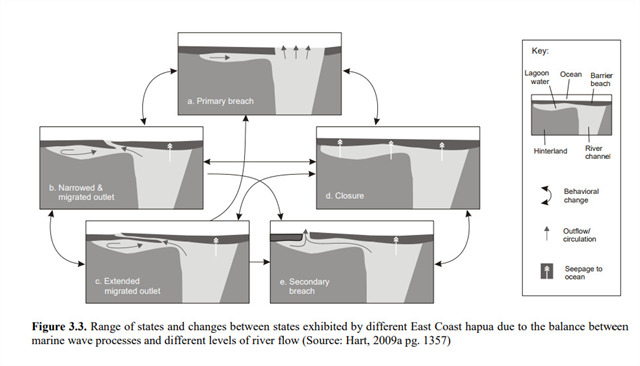
Hapua occur when a braided river interacts with a mixed sand / gravel beach that is affected by longshore drift, and so can occur on the east coast of the South Island. They form when the river, blocked from the sea by a constantly changing sand / gravel barrier resulting from longshore drift, carves out an elongated area parallel to the coast. This results in a highly mobile river mouth (lagoon outlet) as it shifts, usually northwards, over a period of time until a river flood has enough force to break through the barrier resulting in the outlet moving to opposite the end of the river channel.
This cycle is repeated over periods of time lasting as little as several weeks to a year. The river mouth has been recorded as far as 1.5km north of the Hakatere Huts and has moved as much as 90m in a day!
Other examples of hapua are the Rakaia and Hurunui river mouths.
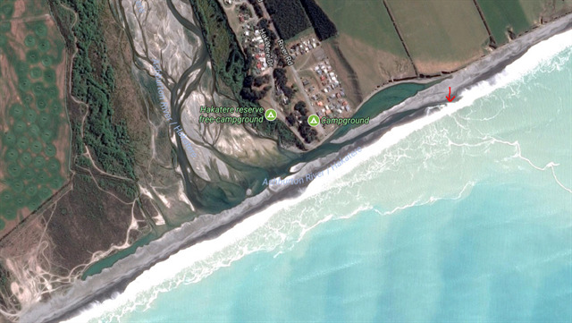
The river mouth at the time this satellite picture was taken is indicated by the red arrow. Notice the long narrow lagoons on both sides of the river channel. (Source: Google maps)
Logging requirements
At the posted co-ordinates there is an informative signboard, unfortunately, it is poorly mounted and the wording on the LHS is obscured, but it has some interesting facts about the area.
Also, you can get a good view of the hapua to the NE, while the WP gives you views to the SW.
Questions to answer:
-
From your observations, where is the river mouth today – estimate the approximate distance from the river channel and say whether it is NE or SW from the channel, or opposite.
-
From your observations and using the diagram below, which part of the hapua cycle does the river mouth show today? (Just need the letter from the diagram).
-
What do you think can happen with low river flow?
-
(optional) Please take a photo of the river mouth so we can have a record of how it changes over time.
Please email me the answers along with the cache name via geocaching.com, and you may log your find before hearing back from me.