
Valle Gargassa
L'anello della Val Gargassa - G➀

 La Valle Gargassa La Valle Gargassa
fa parte del Parco Naturale Regionale del Beigua (dal 2005 riconosciuto come Geoparco) ed è scavata nelle “Rocce Verdi” (le Ofioliti), nelle Calcescisti, e nel Conglomerato (cosiddette Rocce Nere di Rossiglione, in dialetto ligure anche chiamato "Puddinga"); che danno al paesaggio una particolare suggestiva bellezza.
Il torrente Gargassa, affluente dello Stura (che a sua volta si versa nell'Orba, poi nel Bormida, nel Tanaro e finalmente nel Po) scorre inizialmente tra Rocce Verdi levigate dall'erosione delle sue acque, poi tra scure bastionate di Conglomerati Oligocenici (originatisi circa 35 Milioni di Anni fa).
La storia geologica della Val Gargassa inizia nel Giurassico ( 192-135 M A) quando dal fondo dell’Oceano Ligure Piemontese, che separava le zolle Africana e Piemontese, è fuoriuscito un magma silicatico, ricco di ferro e magnesio, proveniente dal sottostante mantello. Quando nel Cretaceo (135-65 M A) i due continenti si avvicinarono, questo materiale del mantello, sul quale si erano depositati enormi quantità di sedimenti calcarei, fu trasportato al di sopra della zolla continentale Europea. Avvennero quindi quelle imponenti trasformazioni che portarono al sollevamento delle Alpi e all'affioramento in superficie del materiale del mantello: le rocce verdi ed i basalti.
Nell’Oligocene (37-23 M a) un nuovo mare andò ad occupare da nord a sud l’ampio golfo situato dove oggi si trova la pianura padana e andò a lambire le pendici settentrionali delle Alpi appena formate. In questo mare padano chiamato Bacino Terziario Piemontese vennero accumulate gigantesche quantità di detriti: massi, ciottoli, sabbie, marne, limi, argille, provenienti dall'erosione del versante settentrionale delle Alpi, le lagune, paludi e fosse vennero riempite progressivamente da questi sedimenti che si depositarono periodicamente a strati, anche di un certo spessore. I sedimenti grossolani, i ciottoli, di origine principalmente serpentinitica e basaltica, vennero alzati, trasportati depositati e poi cementati da elementi più fini come sabbie, marne ed argille. Poi il mare Padano cominciò a ritirarsi per l’innalzamento progressivo del fondo e tutto il versante subì l’erosione da parte delle acque di scorrimento e degli agenti atmosferici; si originarono così gole, strettoie e strane forme rocciose che oggi compongono questa valle unica.
Accesso e Percorso: A Rossiglione prendere per Tiglieto, dopo circa 3 km scendere una stradina a sinistra che porta ad un ampio parcheggio presso il campo sportivo di Rossiglione, località Gargassina.
Da qui puoi percorrere il sentiero ad anello della val Gargassa passando prima da questo Earthcache per poi salire alla Rocca dei Corvi (segnavia XX fino a Case Vereira, poi tre bolli gialli disposti a triangolo).
Circa 7 km, dislivello 250 m, meno di 3 ore.
Questi sono i 5 quesiti ai quali siete pregati di rispondere per loggare questo earthcache:
1)Una valle prima di tutto è una depressione del terreno delimitata da pendii laterali montuosi. In base alla loro genesi le valli si distinguono in due categorie:
- Origine fluviale, solitamente con un profilo trasversale a forma di V
- Origine glaciale, solitamente con un profilo trasversale a forma di U.
Domanda: A quale dei due gruppi appartiene la Val Gargassa ?
2) In base al grado di presenza di seguenti fenomeni:
- Erosione in profondità (incisione),
- Erosione laterale (meandri),
- Denudazione sui versanti,
le valli fluviali sono suddivise in varie tipologie come per esempio:
- La forra (orrido) (immagine a),
- La gola (immagine b),
- La semplice valle a V (immagine c),
- Il canyon (immagine d)
Domanda: Di che tipologia è la Valel Gargassa e quale tra suddetti 3 fenomeni è il più evidente ?
3) Domanda: Di quale tipo di roccia sono composte le pareti nella parte centrale della valle ?
4) Domanda: Come è fatta ? Tale roccia e la sua superficie hanno delle caratteristiche uniche efacilmente individuabili.
Le domande 3) e 4) non fanno per forza riferimento a GZ ma puoi individuare le risposte nell'intero tratto da GZ fino al guado sotto il muso di gatto.
5)Scatta delle foto di te o di qualunque altra cosa che ti è piaciuta particolarmente e allegala al tuo log. ?
Invia le tue risposte a:
Earthcache@CaniSciolti.org
Le domande non fanno riferimento ad un pannello informativo posto in loco o qualcosa di simile.
Grazie per l'attenzione e buon divertimento alla scoperta di questo luogo naturalistico incontaminato !
 The Gargassa valley The Gargassa valley
is part of the Beigua Regional Nature Park (since 2005 recognized as a Geopark) and is excavated in the"Green Rocks " (the Ophiols), the schists , and the Conglomerate (so-called Black Rocks of Rossiglione), which make the landscape particularly unique.
The Gargassa creek, tributary stream of the Stura (which then flow into the Orba, then to Bormida, Tanaro and finally into the Po), runs initially between the Ophiols rocks, eroded its waters and then between dark bastions of Oligocene Conglomerates (originated about 35 million years ago).
The geological history of the Gargassa valley begins in the Jurassic (192-135 M A) when a silica magma, rich of iron and magnesium, came from the bottom mantle of the Piedmont Ligurian Ocean, which separated the African and Piedmont tectonic plates . When the two continents approached the Cretaceous (135-65 M A), this cloak material, upon which huge amounts of limestone sediment had deposited, was transported above the European continental plateau. So they made the massive transformations that led to the lifting of the Alps and the surface surface of the mantle material: the green rocks and the basalt.
In the Oligocene (37-23 M a), a new sea went from north to south to the large bay where today is the Padana plain and has been lying down the northern slopes of the newly formed Alps. In this sea called Piemontese Tertiary Basin, huge amounts of debris were accumulated: boulders, pebbles, sand, marshes, limes, clay, from the erosion of the northern slopes of the Alps, the lagoons, the marshes, the ditches were gradually filled by these sediments that deposited periodically on layers, even of great thickness. Coarse sediments, pebbles, mainly serpentinitic and basaltic origin, venerated raised, transported in a truly violent deposit and then cemented by finer elements: sands, marne, lime and clay. Then the Sea Padano began to retreat because of the progressive rise of the bottom and the whole slope was subject to erosion by the waters and the atmospheric agents; so gorgeous, narrow and strange rock formations were born that today make up this unique valley.
Access & hike : In Rossiglione head towards Tiglieto, after about 3 km go down a little road to the left which leads to a large parking lot at the sports ground of Rossiglione, in the locality Gargassina.
From here you can start a circular walk through the Gargassa valley by heading this Earthcache first and then climb to the Rocca dei Corvi (sign yellow XX up to Case Vereira, then three yellow dots ).
In total this hike has a lenght of about 7 km, difference in altitude 250 m, less than 3 hours.
Please be so kind to answer to these 5 tasks to log this earthcache:
1) A valley isan elongated depression in the ground that is bordered by slopes. According to their genesis valleys are divided into 2 categories:
- Fluvial origin, usually with a V-shaped transverse profile
- Glacial origin, usually with a U-shaped transverse profile.
Question: To which group belongs the Gargassa valley?
2) According to the presence and intensity of the following phenomena:
- erosion in depth (degradation),
- lateral erosion,
- denudation on the slopes,
river valleys are divided into various types such as:
- the ravine (image a),
- the gorge (image b),
- the simple V-shaped valley (image c),
- the canyon (image d).
Question: What type of valley is the Gargassa valley and which of the above mentioned 3 phenomena is the most significant here ?
3) Question: What kind of rock are the walls in the central part of the valley made of ?
4) Question: How it is made ? Such rock and its surface have unique characteristics, partly explained in the above listing. ?
5) Please take a picture of yourself or anything else that you particularly liked and attach it to your log.
Please send the answers to:
Earthcache@CaniSciolti.org
Thank you for your attention and enjoy the discovery of this fantastic naturalistic spot!
 Folgende 5 Aufgaben solltet Ihr bitte lösen um diesen Earthcache zu loggen: Folgende 5 Aufgaben solltet Ihr bitte lösen um diesen Earthcache zu loggen:
1) Ein Tal ist eine längliche Vertiefung der Erdoberfläche welche durch Hänge begrenzt ist. Gemäss ihrer Entstehung sind Täler in zwei Kategorien unterteilt:
- Fluvialen Ursprungs, in der Regel mit einer V-förmigen Querprofil
- Glazialen Ursprungs, normalerweise mit einem Querprofil in U-Form.
Frage: Welcher dieser Kategorien ist das Gargassa-Tal zuzuordnen ?
2) Je nach dem Grad der Gegenwart von folgenden Phänomenen:
- Tiefenerosion,
- Seitenerosion,
- Denudation an den Hängen,
werden Flusstäler in verschiedene Typen unterteilt:
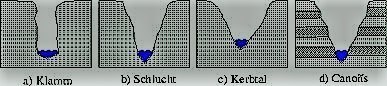
- Klamm
- Schlucht
- Kerbtal
- Canyon
Frage: Was für ein Typ ist das Gargassa-Tal und welches dieser 3 Phänomene ist hier am Stärksten vorhanden?
3) Frage: Aus was für einem Fels bestehen die Felswände im zentralen Teil des Tales ?
4) Wie ist dieser Fels gemacht ? Solche Gesteine und ihre Oberfläche haben einzigartige Eigenschaften, welche u.a. teilweise im Listing erlaeutert werden.
5) Bitte macht Fotos von Euch oder von irgendetwas was Euch hier besonders gefallen hat und fügt sie Eurem Log bei.
Bitte sendet Eure Antworten an:
Earthcache@CaniSciolti.org
Vielen Dank für Eure Aufmerksamkeit und viel Spass bei der Erkundung dieses wunderschönen naturalistischen Ortes!
 |