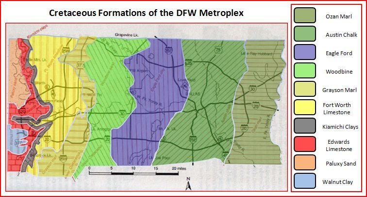
The DFW area sits above Cretaceous-aged layers of sediment (strata), with dates ranging from ≈145-66 Ma (million years ago). These Cretaceous-aged sediments lie above what was once the Ouachita Mountains and an area know as the Fort Worth Basin. From Fort Worth east through the Dallas, Richardson and Garland areas then down towards the Gulf of Mexico, the strata gets progressively younger.
Around 110-85 Ma, there were changes in the amount volcanic rock (magma) being injected into the ocean which caused a displacement of water from the ocean basins, resulting in sea level rise, flooding the coasts of Texas. The dispersal of magma warmed the water in the ocean, and created an ideal environment for calcareous-shelled organisms to thrive. These organisms eventually died and sunk to the bottom of the ocean floor creating thick deposits of limestone - a hard sedimentary rock, usually white in color, composed mainly of calcium carbonate.
Sea levels continued to rise which helped form the 300–500 ft thick Austin Chalk around ≈89-85mya. The Austin formation consists of recrystalized, fossiliferous, interbedded chalks and marls. Austin chalk is often seen in quarries, roadcuts, and stream beds where the water eroded the top soil. Austin chalk is the well known white rock that the city of Dallas sits on, and is the name sake of White Rock Lake. On top of the Austin Chalk, are several sedimentary layers known as the Taylor formation. Deposition of the Taylor layers marks the point of sea level regression which continued until the end of the Cretaceous period. Ozan Marl is the first bed overlying the Austin chalk and can be found underneath the city of Richardson and Garland.
This brings us to ground zero - imagine that where you stand now, was once under as much as 820 feet of water...
To log this Earth Cache, please answer the following questions by sending me a message or e-mail through my profile page:
1. How many distinct sedimentary layers do you see in the cliff face?
2. Directly across Spring Creek from the posted coordinates, there is a visible fault in the Taylor formation. Please provide your best estimate on the amount of shift that took place.
3. Scan the formation from west to east and tell me what you see happening in the layers before you - are they level? If not, what do they do?
4. An optional picture of yourself at GZ would be appreciated!