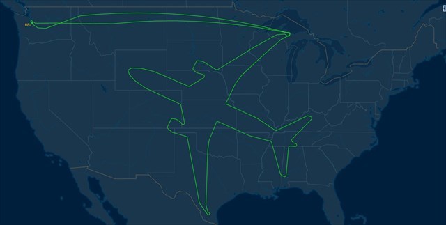
On Aug. 2-3, 2017, Boeing spent an evening drawing an ✈︎ on the sky.
The aerospace giant was testing a upgraded engine for its 787 Dreamliner for long endurance flights and reliability and the company had 18 hours to kill. So its flight planners designed a route that, once finished, looked liked one of its Dreamliner jets.
The route started at Boeing Field (BFI) in Seattle WA heading east on a late Wednesday afternoon. But the fun really started over the Upper Peninsula of Michigan, when the Dreamliner started heading south as it began to trace the shape of an ✈︎. By the time it was done Thursday morning, the wingtips stretched from Michigan to Texas while its nose touched Wyoming and its tail was in Alabama.
While "drawing this art in the sky", the ✈︎ departed from Boeing Field near Seattle WA (BFI) on a 787-8, flew for 18 hours, covering a distance of 9,896 mi before touching down again on BFI. The enormous ✈︎ shape was drawn by the final 787-8 development aircraft, ZA004, during a marathon 18-hour test flight on Aug. 2-3, 2017 for certification of the upgraded Rolls-Royce Trent 1000 TEN. The new engine will not only be Rolls standard powerplant for the 787 ✈︎ family, but it will also be the first to enter service on the stretched 787-10, which debuted in the first half of 2018.
For the extended test flight, ✈︎ ZA004 departed Boeing Field at 3:38 p.m. PST on Aug. 2 and returned 18 hr. 1 min. later at 9:39 a.m. on Aug. 3. The duration of the flight was stretched to ensure adequate time for ETOPS and functional and reliability (F&R) certification by designing a flightpath that drew the outline of a 787 over a number of states. Angled northwest toward Washington state, the outline of the ✈︎ nose was flown over Wyoming, while the wings stretched from northern Michigan, near the Canadian border, to southern Texas. The tail extended from Alabama to Kentucky.
Courtesy: Flightaware Website, http://flightaware.com
PUZZLE:
Count Carefully!
1. Through how many states did the ✈︎ fly? (Each state counted no more than once)
2. Which state(s) did the ✈︎ fly through four times to draw this art? (*)
3. Which state(s) did the ✈︎ fly through three times to draw this art? (*)
(*) Between take-off and landing. If there is more than one state, list them in alphabetical order. This is to ensure the checker works for you.
Note: You should not need a magnifying glass to solve the puzzle.
Put your answer in the checker to obtain the final coordinates. As example, a solution would look like 24CADEAKHI (24 states, 4x through California and Delaware and 3x through Alaska and Hawaii)
If you solved this prior to MAY 31, 2021, run the checker again to get updated coordinates.

You can validate your puzzle solution with certitude.
DISCLAIMER: THE CACHE IS NOT HIDDEN AT OR ON THE LONG BEACH AIR FIELD AND IS NOT LOCATED AT THE POSTED COORDINATES. THE CACHE IS NOT IN OR ON BUILDINGS OR MONUMENTS OR IN FENCED OFF AREAS. NO TREE CLIMBING. NO CLIMBING FENCES. IF MUGGLES ARE PRESENT DO NOT RETRIEVE THIS CACHE AND WAIT UNTIL LATER OR ANOTHER DAY. A KEEN EYE AND A GENTLE HAND IS ALL THAT IS NEEDED TO RETRIEVE THE CACHE.