Introduction
The waters that issue from the seeps and springs on the lower slopes of the eastern flank of Table Mountain have been used since pre-historical times. There are several historically important springs between Rondebosch and Kirstenbosch. Few people realise how these springs - geological features - have contributed to early civic and industrial development of Cape Town's southern suburbs. The earth caches: The Newlands Springs (GC7DQOY); Kommetjie Spring (GC7DTJ7); and Kirstenbosch Spring (GC7DTMC); provide additional information on different aspects of the hydrogeology and historical importance of the springs of Cape Town's Southern Suburbs. Before considering the hydrogeology of the Albion spring its particular contribution to Cape Town's development will be briefly outlined.
TO CLAIM AND LOG A FIND FOR THIS EARTH CACHE YOU NEED TO ANSWER QUESTIONS A TO E AND EMAIL YOUR ANSWERS VIA MY GEOCACHING PROFILE
[Each member of a caching group must submit individual answers.]
ONCE YOU HAVE VISITED THE SITE AND ARE CONFIDENT THAT YOUR ANSWERS ARE CORRECT YOU MAY LOG THE SITE AS "FOUND". IF YOUR ANSWERS ARE NOT CORRECT YOU WILL RECEIVE AN EMAIL INFORMING YOU OF WHICH ANSWERS NEED TO BE CORRECTED TO VALIDATE YOUR LOG. AFTER 7 DAYS LOGS THAT HAVE NOT BEEN VALIDATED WITH ANSWERS WILL BE DELETED.
A. In your own words explain what is meant by the terms aquifer and aquitard.
B. Choose a,b,c or d as your answer.
Most of the earth's liquid fresh water occurs:
(a) In lakes;
(b) In dams and reservoirs;
(c) In wetlands;
(d) In the ground.
C. Which of the following statements [1] or [2] is correct?
[1] The catchment area for the Albion spring is the talus-covered high ground to the north-west, which absorbs the high rainfall precipitated on the south-eastern side of the projecting block of Table Mountain Sandstone as well as the large run-off from the quartzite lying above, and brings this large amount of water into direct contact with upturned edges of the underlying Malmesbury beds.
[2] Rain falling on the mountain summit seeps into surface cracks, fractures, joints and faults and then moves slowly down through fractures that extend from the Peninsula Formation through the Graafwater Formation to the less permeable aquitard basement formations causing groundwater to emerge at the Albion spring.
D. Choose e, f, g or h as your answer.
(e) The Albion spring was an important source of water during the 1800's;
(f) The Albion spring supplies Cape Town with about 4.5 million litres of water per day;
(g) The Albion Spring is the oldest waterworks reticulating water to Cape Town;
(h) e, f, and g are all correct.
E. The emblem of one of the mineral water factories that used to operate on the Albion Spring site has been preserved at GZ. Name this factory. [Note: You will have to visit the site to obtain the answer, it is NOT one of the names in this cache description!]
The Albion Spring's Contribution to Cape Town Suburban Development
In January 1660, Harman Remanjenne was granted a piece of land straddling the Liesbeek, this became known as Rouwkoop estate (the present day Roukoop Road in Rondebosch dates from this era and still straddles the Liesbeek), the estate remained undivided until 1815 when it was split into two, the portion east of the river retained the name Roukoop and that to the west was named De Hoop. An 1816 diagram recording this land transaction clearly shows a spring on De Hoop. The water from this spring (now known as the Albion spring) has contributed directly to the industrial and civic history of Rondebosch, Claremont, Mowbray, Woodstock, and Wynberg.
In 1818 the De Hoop estate was given permission to build a dam across the Liesbeek from which water could be led off to drive the estate's water mill. (This mill stood on the site of the present-day Albion Springs complex.) The Liesbeek water to De Hoop mill is thought to have been supplemented by water from the De Hoop spring though this has not been proven by archaeological site excavations. A further agreement provided that sufficient water could be drawn from the sluice leading to De Hoop mill for Colonel Bird's horticultural activities. The De Hoop mill was the start of industrial activity in Rondebosch.
By the 1820s the water reservoirs on Table Mountain were proving inadequate to keep up with demand. In 1835 the city's water authorities explored the possibility of purchasing the Albion Spring, to supplement the supply to the city centre. The city engineer reported:-
"From there we [the Commissioners] proceeded to Mr J.G.Munnik's also at Rondebosch, distant from Town 5 miles, and have with the permission of the proprietor measured the spring at his place discharging a quantity of about 549036 gallons [~2500 m3] in 24 hours with no other servitude attached thereon than the allowance of drinking water ... of about 4 buckets per diem."
The commissioners recommended the purchase of Mr Munnik's property and its spring so that "the water thereof be reserved for the use of the Town and other public purposes". They recorded: "Your commissioners have further to add that they have good reasons to think that Mr Munnik would be inclined to sell his place with the spring on it at a very remunerative price." But no purchase was made at the time.
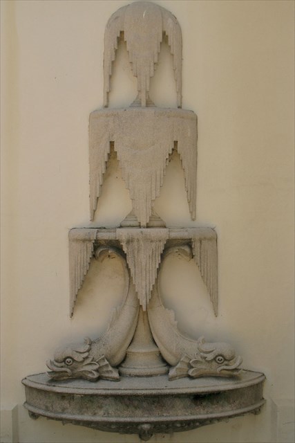
In the mid nineteenth century the Albion spring and surrounding property changed hands and name several times. Between 1883 and 1886 is supplied water to the short-lived Liesbeek Municipality -- with wards Mowbray, Rondebosch, Newlands, Claremont and Wynberg. By this time an ice factory and two mineral water bottling plants - Excelsior and Albion Springs Mineral Water Factories - had been built close to the spring. A relic from another mineral water factory that once used the spring water appears in the adjacent image.
In 1889 the Albion Spring and the small piece of land surrounding it was bought by a private company called Cape Town District Waterworks. This company was owned by Anders Ohlsson who undertook to supply water to the local Municipalities and gave them the option of acquiring the undertaking after ten years. Ohlsson installed steam pumps and by 1891 a supply of over a million gallons of water [4500 m3] per day was being pumped. The pumps and water distribution were apparently too effective and in 1892 the Supreme Court ruled that the Cape Town District Waterworks should allow 500 000 gallons of water [~2250 m3] to flow into the Liesbeek every day to ensure that the river continued to flow.
After 10 years, the municipalities exercised their right to take over the Cape Town District Waterworks Company. The Suburban Municipal Waterworks installed electrical pumps at Albion Spring, and the water was pumped to a small reservoir above Newlands before being reticulated to the municipalities of Woodstock, Maitland, Mowbray, Rondebosch and Claremont. By the early 1900's it was evident that all the Cape Town municipalities would have to look further than Table Mountain and its springs to ensure their water supplies. The need to cooperate to ensure an adequate water supply was a key element leading to the formation of the City of Greater Cape Town through the union of Central Cape Town, Green Point and Sea Point, Woodstock, Maitland, Mowbray, Rondebosch, Claremont and Kalk Bay. The Albion spring nevertheless continued to be the main source of water for the municipalities of Claremont, Rondebosch, Mowbray and Woodstock until 1921 when water was supplied to the City of Cape Town by a 64 km cast iron pipeline from the Steenbras dam in the mountains above Gordon's Bay.
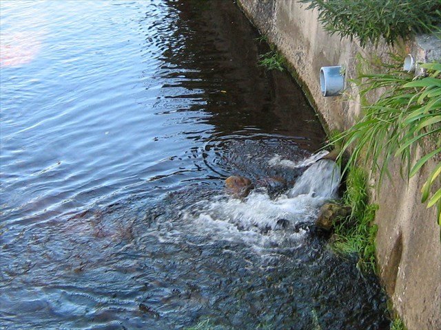
Albion Spring discharge to the Liesbeek
when the water is not being used by Cape Town
The Albion Spring is the oldest waterworks still reticulating water to Cape Town. Water from the aquifer is chlorinated, pH adjusted, and pumped directly into the city's bulk water supply. The spring is rated to supply 4.5 million litres a day to augment Cape Town's water supply. No surface free-flowing spring still exists on the Albion site as water is now pumped from a borehole that taps the aquifer where the spring was located. The water is treated on site using CO2 stripping to neutralise the water. It is then chlorinated before it is added to the bulk water supply pipeline.
The Hydrogeology of the Albion spring
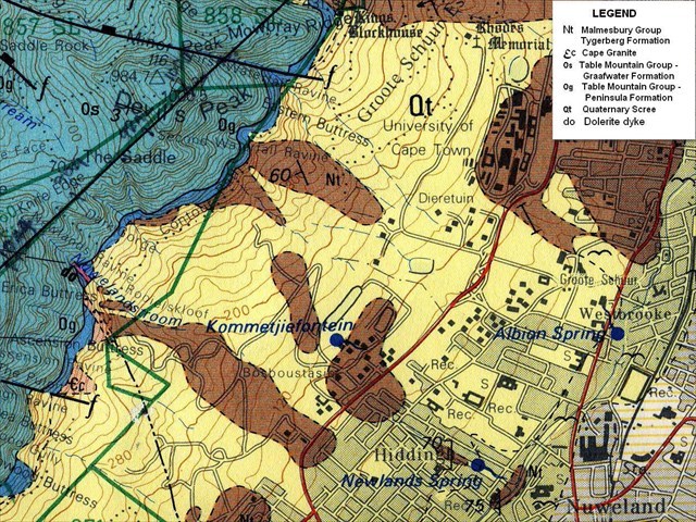
Geological Map Showing Spring Location
Now that we have learned about the role that the Albion spring has played in the development of Cape Town's southern suburbs we need to think about where this water comes from.
It comes out of the ground: yes, that is why it is called groundwater. But all water that seeps, flows, or is pumped out of the earth once fell as rain. Over time, water from rain, streams, and rivers moves down through the ground and is stored in the spaces between grains of soil or rock or in cracks and fissures in rocks. Underground layers of rock that are saturated with water that can be brought to the surface through natural springs or by pumping are called aquifers. The term aquifer is applied to geological units that conduct significant quantities of groundwater, geological units that do not permit groundwater to pass through them are termed aquitards. Groundwater is found in vast quantities and constitutes about 98% of the liquid fresh water on the planet. The study of groundwater and its movement is known as hydrogeology.
In 1933 the geologist H F Frommurze contributed a chapter "Underground Water Resources" to S F Haughton's Geological Survey monograph titled The Geology of Cape Town and Surrounding Country. Much of what he wrote about the aquifer feeding the springs has only been proved correct eighty years later by Roger Diamond using high-tec stable isotope analysis to determine the source of the springs' water. This is what Frommurze wrote:
"Famous for their clear pure water and high yield are the Newlands, Kommetje and Albion springs, all of which issue from the Malmesbury Beds in the suburb of Newlands, Capetown. The catchment area for these springs would appear to be the talus-covered high ground to the north-west, which absorbs the high rainfall precipitated on the south-eastern side of the projecting block of Table Mountain Sandstone, as well as the large run-off from the quartzite lying above, and brings this large amount of water into direct contact with upturned edges of the underlying Malmesbury beds. Percolating into these beds it makes its way along the joints and bedding planes... The Albion Spring below the Main Road, yields 1,OOO,OOO gallons (~4500 cubic metres) per day, the cause of issue at this point appears to be a zone of post-Cape faulting which runs down from the east of Constantia Berg in a northeasterly direction.
There is no doubt that most of the water comes out of the decomposed upper portions of the Malmesbury beds, although the latter are not exposed on the surface, but observation shows that the slates are only a few feet below the surface at both places. Direct contribution to the spring yield from the loose ungraded talus cannot be very considerable except during the period of heavy precipitation, as the measured depth of this deposit is not more than 20 feet [6m] on an average, lying on a very uneven floor."
Until recently Frommurze's view that Newlands spring-water came from an aquifer in the "talus-covered high ground" was disputed.
The suggested and now outdated explanation was that rain falling on the mountain summit seeped into surface cracks, fractures, joints and faults and then moved slowly down through fractures that extend from the Peninsula Formation through the Graafwater Formation to the less permeable aquitard basement formations causing groundwater to emerge as diffuse seeps or springs.
In 2014 Roger Diamond's PhD thesis at the University of Cape Town gave close attention to the springs issuing from Table Mountain itself. Using stable isotope analysis of the spring waters, this study showed that the Table Mountain springs are on average recharged about 1km upslope of the spring and at an average elevation of 330m above sea level. The isotope ratios proved that a significant component of groundwater reaching the springs is from fast and shallow flow, although a deeper component must also exist to account for the steady discharge of and perennial nature of the springs. The study also showed that in feeding the springs the groundwater moves through the scree aquifer at between 15 and 20 meters per day.
Diamond's evidence points to extremely local recharge on the lower slopes of the mountain. The most likely aquifer for the southern suburbs springs is the scree and weathered material overlying the peninsula's basement rocks: the Malmesbury Group rocks in Rondebosch. The Table Mountain Group is not directly involved, except as a supply of boulders and sand that make up the scree material on the slopes of the mountain.
Sources
H F Frommurze, 1933; Underground Water Resources. In, S F Haughton The Geology of Cape Town and Surrounding Country, Geological Survey monograph.
R Diamond, 2014; Stable Isotope Hydrology of the Table Mountain Group. PhD Thesis, University of Cape Town.
Geohydrological Spatial Solutions International, 2015, Hydrogeological Investigation of Existing Water Springs in the City of Cape Town and Environs.
1:50 000 Geological Series Maps 3318 CD and 3418 AB (1984)
| This EarthCache developed by an |
 |
 |