Ridge Ferry Park Wetlands
Ridge Ferry Park found its beginnings in the City of Rome's purchase of the land from the Celanese Corporation. Timber was selectively cut in the early 1980's, with the proceeds used to begin the development of a greenspace and buffer park between the Oostanaula River and Riverside Parkway. Ridge Ferry Park was named for Major Ridge's Ferry, located just north of here and used in 1800's to ferry people and good across the Oostanaula River.
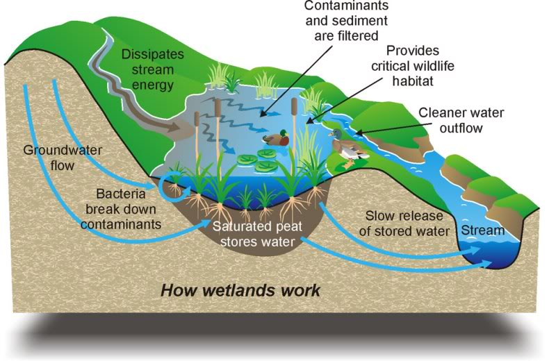
Wetlands provide important services we cannot live without. Their rich diversity of bacteria and algae break down and detoxify wastes, including oil from parking lots and chemicals produced by human activity, purifying the water we depend upon for daily life. Wetland serve as a sponge to soak up rainfall and floodwaters, slowly releasing it back to the land and keeping streams flowing even in times of drought. The Wetlands Demonstration Area near the entrance to the Ridge Ferry Park is a great place to visit to learn about the importance and beauty of these ecosystems.
What is a wetland?
Wetlands are areas where water covers the soil, or is present either at or near the surface of the soil all year or for varying periods of time during the year, including during the growing season. Water saturation (hydrology) largely determines how the soil develops and the types of plant and animal communities living in and on the soil. Wetlands may support both aquatic and terrestrial species. The prolonged presence of water creates conditions that favor the growth of specially adapted plants (hydrophytes) and promote the development of characteristic wetland (hydric) soils.
 The main wetland types include swamps, marshes, bogs, and fens. A swamp is a wetland that is forested. Many swamps occur along large rivers where they are critically dependent upon natural water level fluctuations. A marsh is a wetland that is dominated by herbaceous rather than woody plant species. Marshes can often be found at the edges of lakes and streams, where they form a transition between the aquatic and terrestrial ecosystems. A bog is a wetland that accumulates peat, a deposit of dead plant material—often mosses, and in a majority of cases, sphagnum moss. Fens are usually fed by mineral-rich surface water or groundwater. They are characterised by their water chemistry, which is pH neutral or alkaline, with relatively high dissolved mineral levels but few other plant nutrients. They are usually dominated by grasses and sedges, and typically have brown mosses in general including Scorpidium or Drepanocladus.
Geology and wetlands
Geology plays an important role in the wetland development and the characteristics listed above. Water accumulates in areas where it cannot penetrate the earth below. Some rocks, such as granite, shale and slate are naturally impervious to water. On the other hand, porous rocks can become impermeable if their pores become filled with fine particles from soil or sediments. The landscape also plays a large role in the ability of water to accumulate in an area.
There are different types of wetland landscapes that affect the drainage patterns:
- Topogenous has water movement that is predominantly vertical and overland, resulting in water ponding in depressions such as valleys, basins and floodplains (a stream, feeding a small pond or marsh with no outlet).
- Soligenous has water movement that is predominantly lateral through the soil or discharging from the rock, such as spring (water is bubbling or soaking up out of the ground).
- Flood Plain is a location where the flood rains or high waters form a wetland (an area near a stream or river).
Geology also plays a role in the chemistry of the water that flows through a wetland since the water is affected by the rocks and sediments in the area. The water that flows through a wetland is the source of nutrient elements for the plants and therefore is ultimately the basis of mineral nutrition for all inhabitants of wetlands.
Park Hours:
- The park is open Monday - Sunday: 6:00 am to 9:00 pm.
Prior to logging this cache, email the answers to the following:
- A wetland is an ever changing ecosystem. Describe how the wetlands appears on the day of your visit.
- Based on your observation, is this area a swamp, marsh, bog or fen?
- There are different types of wetland landscapes that affect the drainage patterns. Does this wetland have an outlet or does the area appear to be in a low laying area?
- Based on your previous conclusions would you say it is Topogenious or Flood Plain?
Resources:
- USGS National Water Summary on Wetland Resources (link)
- Utah Geological Survey (link)
- U.S. Environmental Protection Agency (link)
- Biomes of Earth: Wetlands, Peter D. Moore 2006