Introduction
The waters that issue from the seeps and springs on the lower slopes of the eastern flank of Table Mountain have been used since pre-historical times. Few people realise how these springs - geological features - have contributed to early civic and industrial development of Cape Town's southern suburbs. The earth caches: Albion Spring (GC7DNQJ); The Newlands Springs (GC7DQOY); and Kirstenbosch Spring (GC7DTMC); provide additional information on different aspects of the hydrogeology and historical importance of these springs. Before considering the hydrogeology and the actual location of the Kommetjie spring its contribution to Cape Town's brewing industry will be briefly outlined.
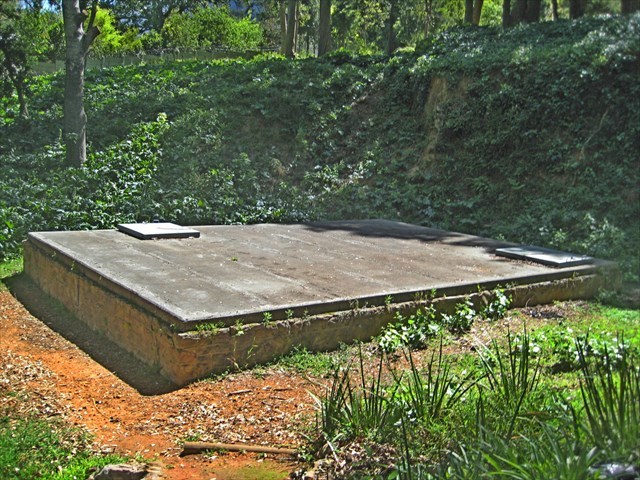
Kommetjie Spring Collection Chamber 2017
LOGGING REQUIREMENTS
TO CLAIM AND LOG A FIND FOR THIS EARTH CACHE YOU NEED TO ANSWER THE FOLLOWING QUESTIONS AND EMAIL YOUR ANSWERS VIA MY GEOCACHING PROFILE.
[Each member of a caching group must submit individual answers.]
ONCE YOU HAVE VISITED THE SITE AND ARE CONFIDENT THAT YOUR ANSWERS ARE CORRECT YOU MAY LOG THE SITE AS "FOUND". IF YOUR ANSWERS ARE NOT CORRECT YOU WILL RECEIVE AN EMAIL INFORMING YOU OF WHICH ANSWERS NEED TO BE CORRECTED TO VALIDATE YOUR LOG.
1. Where is the recharge area for the Kommetjie Spring?
2. What geological feature causes groundwater to emerge forming the Kommetjie Spring?
3. Explain in your own words why the exact source (or "eye') of Kommetjie Spring is not known?
4. What are the approximate dimensions (in meters) of the sandstone collection chamber of the Kommetjie Spring?
Kommetjie Spring and Early Cape Breweries
The clear water springs of Newlands have played a key role in the development of beer brewing in South Africa. The early Newlands settlements and estates were dependent on the springs for domestic and industrial use. The first brewery licence was granted in 1694 to the Papenboom estate which used the Papenboom spring [later to be known as the Kommetjie spring] for a supply of clear water to brew beer. By the late 19th century there were a number of breweries in Newlands using the springs in the vicinity. They were the Cannon Brewery -- which drew its water from the Cannon stream; and the Newlands, Anneberg, and Mariendahl Breweries that drew their water from the Newlands spring. By 1890 all these breweries had been acquired by Anders Ohlsson and consolidated into Ohlsson's Cape Breweries. This was later to be incorporated into the S A Breweries, with headquarters at the Mariendahl Site. Persons with more of an interest in the role that the spring has played in the brewing industry than in its hydrogeology are advised to consult Beatrice Law's book, Papenboom In Newlands: Cradle of the Brewing Industry. Published privately in 2007.
The Hydrogeology of the Kommetjie Spring
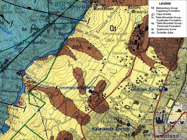
Geology Map Showing Location of Kommetjie Spring
In 1933 the geologist H F Frommurze wrote:
"Famous for their clear pure water and high yield are the Newlands, Kommetjie and Albion springs, all of which issue from the Malmesbury Beds in the suburb of Newlands, Cape Town. The catchment area for these springs would appear to be the talus-covered high ground to the north-west, which absorbs the high rainfall precipitated on the south-eastern side of the projecting block of Table Mountain Sandstone, as well as the large run-off from the quartzite lying above, and brings this large amount of water into direct contact with upturned edges of the underlying Malmesbury beds. Percolating into these beds it makes its way along the joints and bedding planes until in the case of the Kommetje Spring its progress is impeded by a dolerite dyke in the slates; at this point an average flow of 1OO,OOO gallons (~450 cubic metres) per day issues."
In 2014 Roger Diamond's showed that the Table Mountain springs are on average recharged about 1km upslope of the spring and that a significant component of groundwater reaching the springs is from fast and shallow flow, although a deeper component must also exist to account for the steady discharge of and perennial nature of the springs. The study also showed that in feeding the springs the groundwater moves through the scree aquifer at between 15 and 20 meters per day.
The Kommetjie spring no longer supplies potable water. The South African Breweries has the rights to 320 m3 of water per day from this spring but only uses a fraction of this quota. The bulk of the water from this spring is used by the South African College School (SACS) to water its playing fields.
Where is the Eye of Kommetjie Spring?
The precise location of the Kommetjie spring is contentious. The 1984 geological map of Cape Town shows the spring to the west of the present M3 highway where the Malmesbury Group outcrops. However, a hydrogeological study of Cape Town's springs conducted for the City of Cape Town in 2015 gives the stone-walled collection chamber from which the water is piped to SACS as the coordinates of the spring. These coordinates correspond to those given for the Kommetjie spring in the Find A Spring Listing of world fresh water springs. This location is east of the M3 freeway.
The reason for this discrepancy may be because in the Newlands area the less permeable aquitard basement formations and the presence of a dolerite dyke are causing groundwater to emerge as diffuse seeps rather than as clearly defined point sources. Occasional flowing springs occur in the Kommetjie seepage area, both east and west of the collection chamber.
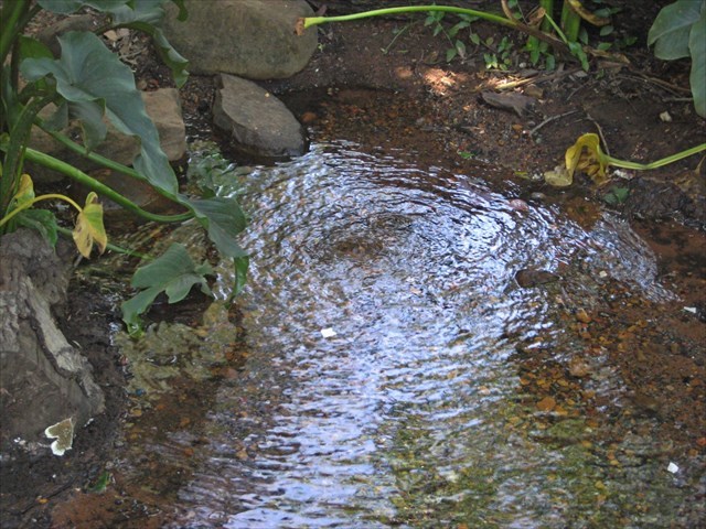
A Flowing Spring in the Kommetjie Seepage Area
While attempting to resolve the precise source of Kommetjie spring a Cape Town City Water Services employee, who has had occasion to descend into the collection chamber, told the author of old pipes leading west from the chamber under the present day M3 freeway. So it is likely that over time the water from a diffuse seep has been directed to the masonry collection chamber so that this is now regarded as the source of the water. No maps or diagrams showing the precise location from which either the Papenboom or the Cannon breweries drew their water have been located.
Sources
H F Frommurze, 1933; Underground Water Resources. In, S F Haughton The Geology of Cape Town and Surrounding Country, Geological Survey Monograph.
R Diamond, 2014; Stable Isotope Hydrology of the Table Mountain Group. PhD Thesis, University of Cape Town.
The History of Foresters Arms. [http://forries.co.za/our-history/]
Geohydrological Spatial Solutions International, 2015, Hydrogeological Investigation of Existing Water Springs in the City of Cape Town and Environs.
1:50 000 Geological Series Maps 3318 CD and 3418 AB (1984)
| This EarthCache developed by an |
 |
 |