
Zona húmeda Laguna de Canyamel
Te encuentras en un espacio singular. Aquí las aguas forman una laguna, hábitat de gran diversidad de especies. Existe un recorrido por la ribera del torrente, de cerca de 500 metros. Está totalmente adaptado a minusválidos e invidentes. Encontrarás explicaciones a lo largo del camino, que te ayudarán a comprender la importancia de este espacio, complementario a la playa. Muy recomendable el paseo.
Espacio protegido
Es un espacio declarado Área Natural de Especial Interés en 1991.
También el Cap Vermell se encuentra protegido, bajo Zona de Especial Conservación de las Aves, ya que allí anida el Cormorán moñudo. En la parte alta del torrente hay un bosque de encinas que también es reserva natural.
Formación de la zona húmeda
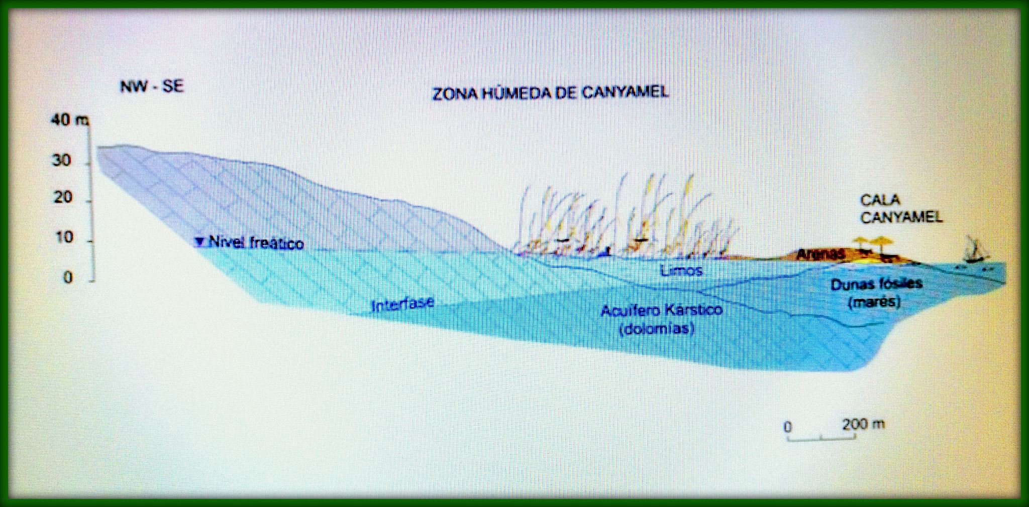
La laguna de Canyamel es una de las zonas húmedas que hay en Mallorca. El torrente recoge las aguas de una extensa cuenca hidrográfica, constituida principalmente de calizas y dolomías del Jurásico inferior. Con sus 80 km² es la tercera cuenca en extensión del Llevant de Mallorca. Además nos encontramos en una zona lluviosa, gracias al efecto de las montañas de las Sierras de Llevant. La red superficial de drenaje de estas montañas está formada mayoritariamente por pequeños torrentes de montaña, que pasan a formar valles sinuosos y bastante encajados cerca de su desembocadura. La erosión del torrente en su tramo final genera una zona hundida respecto al nivel del mar, que corta el nivel freático del acuífero. La playa constituye una barrera física al flujo superficial del agua del humedal hacia el mar. También reciben aportes de agua subterránea. Así es como justamente en este espacio, se encuentran aguas permanentes todo el año formando la zona húmeda conocida como Estany de Canyamel.
Hábitat de Ribera
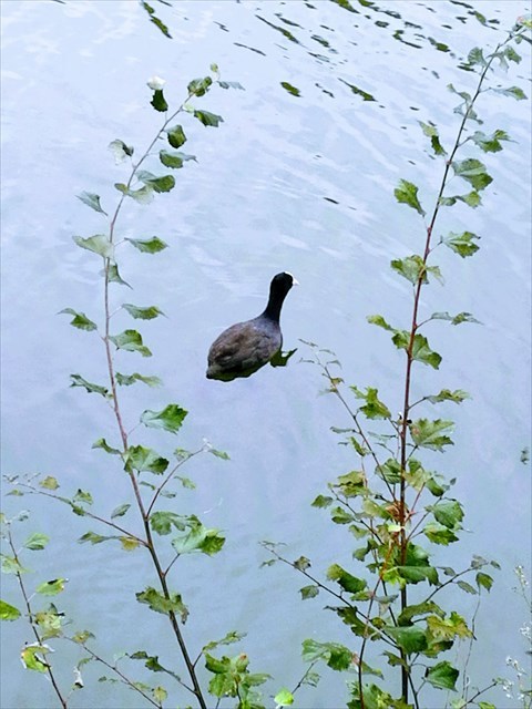
Los humedales poseen una vegetación especial denominada freatofítica, es decir, obtienen el agua de la zona freática o saturada del suelo. Su nombre proviene del griego, y significa “plantas pozo”, ya que actúan como auténticas bombas hasta la atmósfera. El principal habitante de la ribera es el carrizo (Phragmites australis), que con sus raíces fija la tierra de las riberas y además sirve de cobijo para las aves acuáticas. Una zona húmeda es una mina de biodiversidad, ya que hay mucho recurso alimenticio disponible y refugio para muchas especies.
Un bosque de ribera único
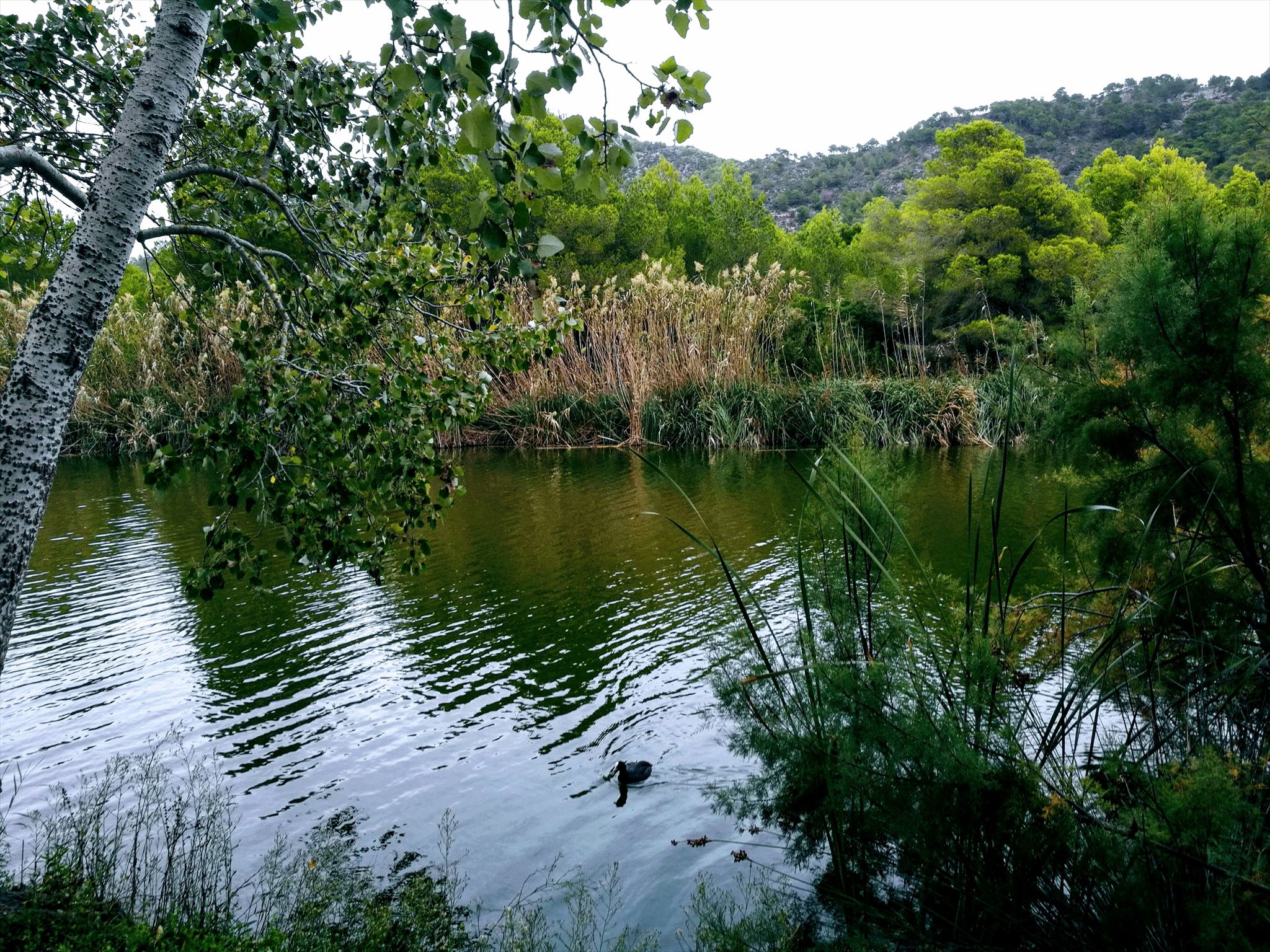
Esta ribera del torrente alberga una población de álamos (Populus alba) excepcional. En toda la isla no existe un bosque tan bien desarrollado, ya que otros que eran así de importantes como en s’Albufera de Alcudia, por ejemplo, han sido atacados por una plaga de mariposa nocturna. Los álamos son de hoja caduca, y tienen la característica de tener una cara verde y la otra blanca. Al tacto la cara blanca tiene una vellosidad suave. La corteza de este árbol es rugosa y blanca también.
El caché
En las coordenadas dadas, nos situamos justo en donde la laguna se encuentra con la playa. Para poder registrar este Earthcaché deberás de enviar un e-mail a nuestra cuenta de perfil con las respuestas a las siguientes preguntas:
- Explica con tus propias palabras y brevemente como se ha formado la laguna.
- ¿Cuál es la composición de la arena? ¿Distingues más de un color en el granulado?
- Calcula aproximadamente la profundidad de la laguna justo en el lugar donde te encuentras. (La profundidad varía según la época del año y las lluvias)
Opcionalmente puedes adjuntar alguna foto desde cualquier punto de l’Estany de Canyamel en el registro del caché.

Laguna de Canyamel wetland
You are in a protected area. Here the waterways broaden into a lagoon, providing a habitat for a wide variety of species. There is a tour along the banks of the torrent, about 500 meters. The walkway has been specially adapted to both handicapped and blind visitors. Along the path there are information panels to help you understand the importance of this area, above and beyond that of the beach. It’s here to enjoy. .
Protected area
This area was designated as a Nature Area of Special Interest in 1991.
Cap Vermell is also protected as a Special Bird Conservation Area, as it is a nesting ground of the European Shag. Above the stream there is a Holm-Oak grove which is also a Nature Reserve.
Formation of the wetland
The Canyamel Lagoon is one of the eight wetlands in Majorca. The stream gathers water from an extensive drainage basin, consisting mainly of limestone and dolomites of the lower Jurassic, covering 80km², making it the third largest in Majorca’s Eastern Area. This is also a rainy area, thanks to the effect of the mountains of the Eastern Sierra. The superficial network of drainage of these mountains is formed mainly by small torrents of mountain, that happen to form valleys sinuous and quite fit near its mouth. The erosion of the torrent in its final section generates a sunken zone with respect to the level of the sea, that cuts the water table of the aquifer. The beach constitutes a physical barrier to the surface flow of water from the wetland to the sea. The lagoon is also fed by groundwater seepage. This makes the area a perennial wetland, known as the Estany de Canyamel.
Waterside habitat
The wetlands have a special vegetation denominated phreatophytic, that is to say, obtain the water of the phreatic zone or saturated of the ground. Its name comes from the Greek, and means "water well plants", as they act like real bombs to the atmosphere. The banks are mainly populated by reeds (Phragmites australis), which holds the earth together with its roots and also gives shelter to water birds. A wetland is rich in biodiversity, offering ample food resources and shelter to many species.
A unique waterside forest
This bank of the stream is home to an exceptional population of White Poplars (Populus alba). It is the most fully developed grove on the island. In other areas previously populated by white poplars; such as the Albufera of Alcudia, they have been attacked by a plague of moths. Poplars are deciduous trees, with leaves that are green on one side and white on the other. The white side is velvety smooth. The bark of the tree is rough and white too.
The cache
At the coordinates, we are just located where the lagoon meets the beach. In order to register this Earthcaché you must send an e-mail to our profile account with the answers to the following questions:
- Explain briefly and in your own words how the lagoon has formed..
- What is the composition of the sand? Do you distinguish more than one color in the granulate?
- Calculate approximately the depth of the lagoon right where you are. (The depth varies according to the time of year and the rains)
Optionally you can attach a picture from any point of the Estany de Canyamel in your log.

Feuchtgebiet laguna de Canyamel
Sie befinden sich in einem Schutzgebiet. Die Wässer bilden eine Lagune, Heimat einer Vielfalt von Lebensarten. Hier beginnt ein knapp 500-Meter-langer Uferwanderweg, der für behinderte und blinde Menschen völlig adaptiert ist. Auf dem Weg finden Sie Inormation zum Verständnis der Wichtigkeit dieses Raums, der als Abwechslung zum Strandalltag dienen soll. Genießen Sie ihn!
Schutzgebiet
Sie befinden sich in einem Gebiet, das im Jahre 1991als Gebiet Besonderen Landschaftlichen Interesses ausgezeichnet wurde. Dazu ist Cap Vermell ein Vogelschutzgebiet, in dem dieKrähenscharbe nistet. Im Oberlauf des Baches wächst ein Steineichenwald, der ebenfalls ein Schutzgebiet bildet.
Bildung des Feuchtgebiets
Die Canyamel-Lagune ist eines der acht Feuchtgebieten Mallorcas. In den Bach fließt Wasser aus einem umfangreichen Einzugsgebiet, bestehen hauptsächlich aus Kalkstein und Dolomit des unteren Juras. Mit 80Km² ist es das drittgrößte Feuchtgebiet vom Osten Mallorca. Außerdem bilden sich häufige Regengebiete in den östlichen Gebirgszügen. Ween das Wasser dieses Gebiet erreicht, findet es einen wasserdichten Boden und eine Sandbarriere, vor der das Wasser staut. Auch Grundwasser fließt in die Lagune. So ist es, dass gerade hier ein ganzjährig andauernder See entstanden ist, der als Estany de Canyamel bezeichnet wird.
Uferhabitat
Die Feuchtgebiete haben eine besondere Vegetation namens phreatophytic, das heißt, das Wasser der phreatic Zone oder gesättigt des Bodens zu erhalten. Sein Name kommt aus dem Griechischen und bedeutet "Wasserbrunnenpflanzen", da sie wie echte Bomben an die Atmosphäre wirken. Besonders verbreitet am Ufer sind Schilfrohre (Phragmites australis), die mit ihren Wurzeln das Erdreich am Ufer festigen. Darunter finden viele Wasservögel Schutz. Ein Feuchtgebiet ist biodiversitätsreich, weil so viele Nahrungsstoffe vorhanden sind und weil so viele Arten dort ein Zuhause finden könne.
Ein einzigartiger Uferwald
An diesem Bachufer wächst ein einzigartiger Silber-Pappel-Hain (Populus alba). Nirgends auf der Insel gibt es einen so prächtigen, den andere Wälder, wie zum Beispiel an der Albufera von Alcudia, wurden durch Nachtfalterschwärme zerfressen. Pappeln sind Laubbäume, deren Blätter auf einer Seite grün, auf der anderen weiß sind. Die weiße Seite ist samtweich. Die Rinde dieses Baums ist rauh und ebenfalls weiß.
Der Cache
An den Koordinaten befinden wir uns genau dort, wo die Lagune auf den Strand trifft. Um dieses Earthcaché zu registrieren, müssen Sie eine E-Mail an unser Profilkonto mit den Antworten auf folgende Fragen senden:
- Erklären Sie kurz und mit eigenen Worten, wie sich die Lagune gebildet hat.
- Wie ist die Zusammensetzung des Sandes? Unterscheiden Sie mehr als eine Farbe im Granulat?
- Berechnen Sie ungefähr die Tiefe der Lagune genau dort, wo Sie sich befinden. (Die Tiefe variiert je nach Jahreszeit und Regen)
Optional können Sie Bilder von jedem Punkt der Estany de Canyamel und poste es mit dem Log.