This cache was originally planned as an earthcache at the start of Chesterfield Canal, highlighting the differences between natural rivers and artificially created canals. Unfortunately this didn't have enough natural geological criteria to class as an earthcache, so rather than scrapping it I have made it into a multi cache instead. For those interested in learning more about the canal I will keep the original bulk of information at the bottom of this cache page, but you do not need to go through the text or email me any answers to claim a find on the cache. All you need to do is visit the area, observe the signs and clues, then work out the coordinates for where the cache is hidden. There is no need to go right to the water's edge for the cache or any of the clues, so it is safe for the children to join in. The canal path is potentially accessible for wheelchair users but the closest access paths to this location involve either steps or steep slopes so access from further along would be needed. The waypoints should all be accessible although assistance may be needed to retrieve the actual cache as the location may be unsuitable for wheelchairs. Unfortunately there is no parking immediately by this part of the canal.
The cache is hidden at:
N 53° AB.CD W 1° EF.GH
Visit the first waypoint at N 53° 14.781 W 1° 25.177 which is on the towpath opposite to the overflow. In the middle of the overflow are a number of stone pillars standing up which look like they used to support a bridge. How many pillars are there?
[Answer = E]
Now head towards the second waypoint at N 53° 14.825 W 1° 25.179 which is over the bridge to the other side of the canal. On the way towards the bridge you will see a few concrete steps in the grass banking. How many concrete steps are there (not including the top and bottom grass steps)?
[Answer = F]
From the bottom of these steps you can see a black oval sign on the bridge wall which says it is Tapton Mill Bridge, but which number?
[Answer = A]
As you head over the bridge you will notice that on the left hand side (South side) there are some newer-looking smoother stone slabs on the top of the wall, which change to rougher stones on the other side of the canal. Count how many of these smoother stones there are, then divide this number by 2 to get the needed answer.
[Answer = D]
Following on from the previous smooth slabs you will then see there are rougher-cut stone slabs on the other side of the canal. Count how many of these there are and multiply by itself (square it) to get the final number.
[Answer = C]
At the final waypoint there is a black signpost on the west side of the canal. How many miles does it say there are to Staveley?
[Answer = B]
Add up the total number of letters in the three words above 'Chesterfield' on the left fork of the sign.
[Answer = G]
Check the wording on the whole sign for the amount of times the word 'Tapton' is used.
[Answer = H]
You should now have all the answers for A to H and be able to work out the final coordinates of the cache. This is a small-sized camouflaged container located approximately a metre off the ground and may be hidden amidst some ivy and prickly thorns so take care. There is a log sheet and pencil inside the cache, along with space for the odd small trackable.
Original earthcache information
The following information is for interest only. There are no answers for this multicache contained within it, as it was originally included for earthcache reference which is no longer needed. The factual information looks at:
- What canals are and how they differ to rivers
- When was this canal made and why
- Where does the water come from, go to, and how does it stay where it should be
- How the land alters the look and features of the canal
- What maintenance is required (proactive and reactive)
- What benefits or hindrances to nature can be seen
What Are Canals?
There are two main types of canals. The first one as we can see here is for navigation. The other reason is for irrigation of farmland to divert river water to the fields where rows of crops are placed, although that is not very common in the UK as we tend to have much more rain than countries that use this method a lot. These British canals were typically built in the late 1700s or early 1800s, and were to transport large loads of goods or raw materials over many miles. This was before the railways came into existence (which essentially then killed off the canal business) as before this the loads were generally transported by pack horses in small loads. This is why the British canal waterways were sometimes described as the 'arteries of the industrial revolution' as they kept the 'blood' of industry moving, i.e. they kept the vital raw materials and finished products moving around he country to where they were needed. Some boats were used for haulage before this on rivers, and this is where the idea came from. River transportation had two major natural problems that limited their use. One was the problem of varying widths, depths, currents and tight twists that could prevent safe passage for boats. The other problem is that rivers are natural and they go where they go, which may not necessarily be where you want boats to go. There may be minor manipulation of rivers in the form of landscaping for effect (such as the twisting rivers at Chatsworth) or slight re-direction in towns and city centres to keep the river away from buildings but this is expensive and hard to control, as swollen rivers can break banks and find their natural way again. This leads to the fundamental definition of canals, in that they are artificially created waterways for a purpose. The whole routes were planned, the channels gouged out of the land and the accompanying paths built (initially for horses to pull the boats rather than pedestrians). All you need then is to add water!
Water Supply and Maintenance:
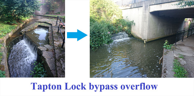
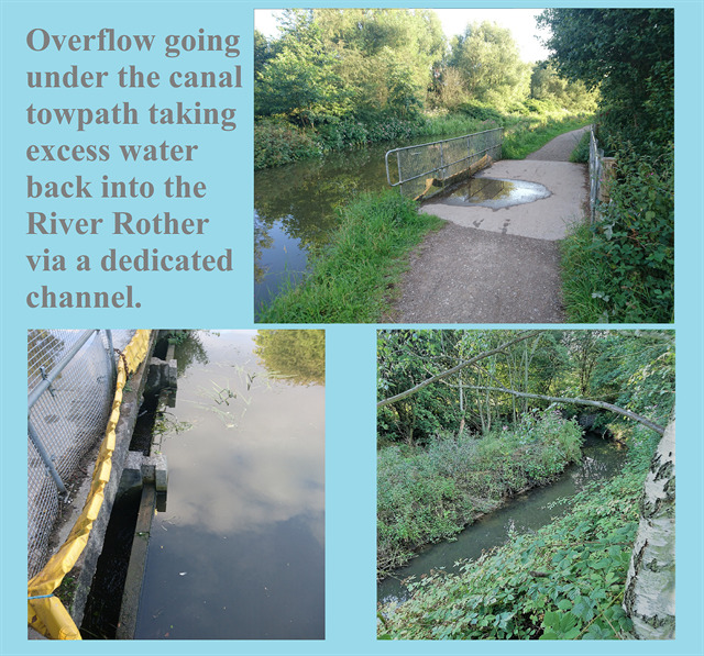
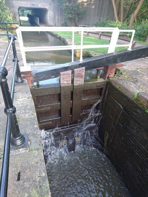
Unlike rivers which form naturally from small tributaries of water running off the hills and mountains, following natural grooves in the landscape, canals on the other hand need 'feeding'. There could be a small amount of water running off the land or raining into the canals but this isn't enough to maintain them so they need the water supply of a river to kick them off. The coordinates of this cache take you to a location which shows exactly this situation. The river Rother flows through the centre of Chesterfield and then right into the path of where the canal start was constructed. The straight flow of the river actually becomes the path of the canal at this point, with a split off to the left for water to also continue the route of the river down an initial waterflow. There is then a large overflow from the canal back to the river just below the waterfall. Shortly after this first overflow are the starting flood gate and weir as the first structures you will notice on the canal. These all keep the starting height of the canal constant, and the bigger than normal overflow takes excess water back to the river which is a fair way below by this point. It is hard to see from the towpath but the photo does show how the river has already dropped a few metres alongside the first 20 metres of the canal with a little waterfall built into the layout, so there is little chance of the river flooding here and therefore little chance of the canal flooding too. This is crucial to avoid too much water right at the start of the canal system. A further series of sluices and overflows will help regulate the height of the water along the rest of the canal. These overflows are sometimes allowing heavy excesses to flow back into a river running alongside, but there are nearly always overflows at locks which will take this extra water around the lock gates to the lower water level after the lock.
By doing this it ensures each new height level of the canal is 'fed' just as the start of the canal was, rather than having all overflows taking water out of the canal system. Although canals typically do not 'run' like a river they will still lose water which is why they need a constant feed at the start. The biggest loss of water is when using the locks and taking a huge chunk of water down to the lower level of the canal at this point. Nowadays there is little boating taking place so the locks are not used too much and the overflows are regularly wet. There are little streams and tunnels taking overflow water away through the trees to the river if you look carefully in parts of the canal.
Some canals with bigger drops in the landscape need whole sets of locks, called 'staircases' so these need a more plentiful supply of water at the start. The Chesterfield Canal doesn't need to utilise many locks over its distance so water supply is easier. On some canals, such as the Llangollen Canal in Wales, there is a much bigger capture of water from the river at the start of the canal system as it doesn't get fed from other rivers along the way but goes on for many miles and even feeds another canal. This results in a more noticeable flow of water passing by at about 4 miles per hour, which doesn't sound much until you think that 4mph was the official speed limit of canal boats, so they needed that horsepower or engine power going up the canal just to fight the current. You can see a slight movement of water on the Chesterfield Canal but this is minimal unless it's right by the overflow points. Some canals are fed from other canals (rather than rivers), at a point way downstream from the original constant supply of a river. These secondary canals may have had restrictions on passage in the past if they had a few locks on them, as there was a danger of not being replenished enough so only a set number of boats-per-day or lock-openings were allowed on that section.
The other potential loss of water from canals beside the lock gates and overflows is water seeping into the ground or through the raised sides. As the canals were artificially created then there's no rock or stone base to the canals that a river may have worn down to, so the canals tended to be lined with a thick clay or had brick walls built to allow for a severe drop that still retained the water but allowed boats to pull right in to the side for mooring or passing other boats. In some places the canals may be raised from the surrounding land so the construction of the canals also had to ensure water wasn't seeping through the sides of the canal onto surrounding land. Occasionally leaks have occurred and repairs are needed, usually by emptying a section of canal so there is only a trickle of water through that part and the muddy edges can be built back up. The lock gates downstream from the section are left open and the water soon empties into the lower sections. This happened a couple of years ago by the Bluebank Lock (lock number 4) where the nearby access path ran 2 metres below the height of the canal and towpath, and you could often see water running across this lower path.
Naturally Selected Route Of The Canal:
Although canals aren't naturally forming in the landscape like rivers, there are still similarities in the way they curve round and follow the land. Although it may seem sensible to built canals in straight lines for the least amount of digging, construction time and cost, this isn't always the case. Even roads curve around hills rather than going up and down more, but with canals it was much more important because water cannot be allowed to go down slopes. Even rivers would not be navigable if drops in the land were too significant and resulted in rapids or waterfalls. Canal boats are very flat bottomed, which allows for the canals to be quite shallow and were therefore quicker, easier and cheaper to build. Even with the weight they were carrying there wasn't much water displacement and the middle of these narrow canals are only around a metre in depth. The tricky part of any adult falling in the water is not to keep their head above water, it is more about not getting stuck in the mud and then trying to get out on the muddy sides, even though the water here is often less than half a metre deep. If the height of the overall canal varies then locks need to be built and these were a lot more expensive to build, but also could add significant time to canal journeys which in turn also increased operational costs. If canals can flow round hills on the same height then it made things cheaper and easier. The other option was to go straight through a hill by building a tunnel but this again was a very expensive method which was only used as a last resort. There were a few tunnels on the Chesterfield Canal route but the biggest of these, the Norwood Tunnel, kept having issues of collapsing and eventually they deemed it too expensive to repair so it remained collapsed and therfore closed off the canal to other canals. The material they were tunnelling through was not the most solid and there had been mining of the ground too so it was inevitable there would be problems. Some sections of canal didn't need digging out, as there may have already been a significant slope on one side of the canal, so all they needed to do was build up the other side to retain the water and usually host the towpath on that side.
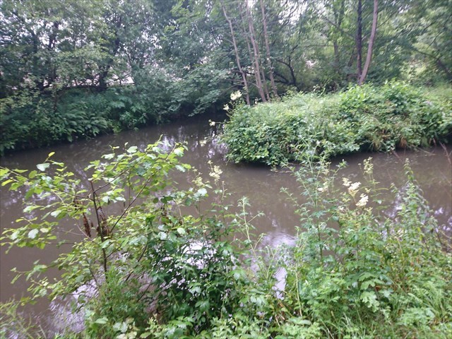
There may be wider sections in these areas, such as on the Chesterfield Canal between Wheeldon Mill Lock and Bluebank Lock, or just upstream from Tapton Lock (see photo above), which have the appearance of a river rather than a canal. These sections could also act as a convenient natural turning point, rather than having to build these into the canal path.
Maintenance- Proactive & Reactive:
We have already looked at one aspect of reactive maintenance, talking about the leaks that can occur when you are holding a large body of water in place with essentially just an earth mound and water will naturally find a way to creep through. Another example of leaking is down to the canal locks. The gates are built and angled in such a way that the pressure of the water from upstream presses against the lock gates to keep them closed. If you have ever been canal boating you may know that water needs to be let out through underwater channels when using lock gates, and only when the water level is even on both sides of the gates can they be opened. The force of water otherwise is literally tons pressing against the gate. Even so, water can leak through if they are not perfectly flush edges, but over time the wooden gates can rot and the water seeps through more and more.
The gates at Bluebank Lock were replaced only a few years ago for this reason, and further down at Dixon Lock you can see an old lock gate on the bank side rotting away, totally ravaged by nature now. As there is no way to 'turn off the tap' at the start of the canal then the water will keep coming, so just like when they have to repair a section of canal wall, they also need the water to bypass an area when they are fixing lock gates. Each lock has vertical posts with grooves in right before the gate, much like with concrete fence posts in a garden. There are custom-made planks stacked up by the locks which slot in to these grooves one on top of the other until they reach above the water. At this point the sleuces and gates can be opened at both ends of the lock and the water is held by the planks, with excess water going down the overflow around the section.
If we now look at proactive maintenance, there is one big natural problem that modern canals can have which means that they need to be regularly maintained to avoid an issue. As the water is largely static and shallow then weeds can become a problem. Whilst weeds can grow in any waters, they are less noticeable in rivers because of the flow which would limit the growth. In canals they have a good supply of mud and little to disturb them. When the Canal Society started working on the restoration of the canal, the canals had not been used for traffic for so many years that the weeds had built up more and more each year. In some areas you could find it difficult to see any water there as the weeds on either side had met in the middle to form a carpet of green. There was much work needed in ripping out the weeds and dredging the canal where the roots and mud had built up so much that it would restrict the passing of boats. When canals were used regularly there were always boats passing up and down so the growth of weeds was not an issue. Even now, after the initial clearing of sections there still has to be work teams who keep tackling the build up of weeds before it gets to being a problem.
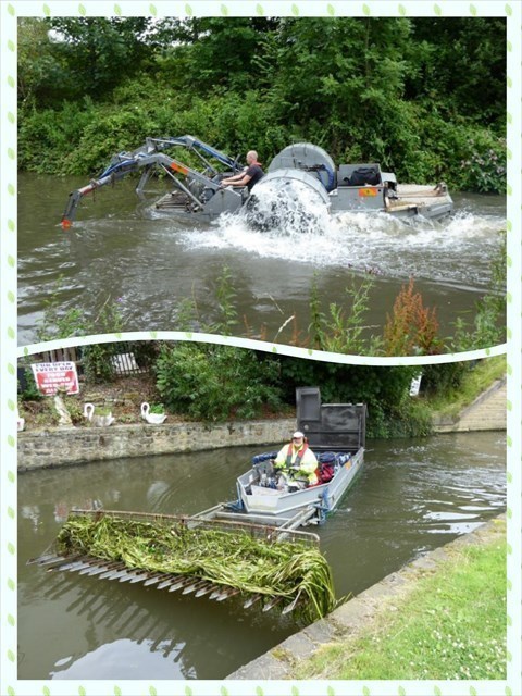
(Thanks to the Chesterfield Canal Society for allowing me to use this photo from their website)
There are occasionally a couple of grass and weed cutting boats on the canal, the first one with large vertical cutters in front of the boat going down the banks like a lawnmower would on grass, then the other boat follows with a giant metal 'comb' on the front to scoop up the loose weeds. There is only the one tour boat (The John Varley II) in semi-regular use on the canal, but this alone doesn't move enough to keep all the canal sections clear of weeds and silt build up. Other boats are brought onto the canal occasionally but as it is separated from other canals they need bringing by road and winched onto the water.
One issue that canals can also face is stagnant water. Whilst this was never a particular issue that stopped people using canals it can nevertheless have an impact. Besides the weed issue mentioned above, there can be a slight smell from water if it becomes too stagnant, and there may be a build-up of surface scum at lock gates.
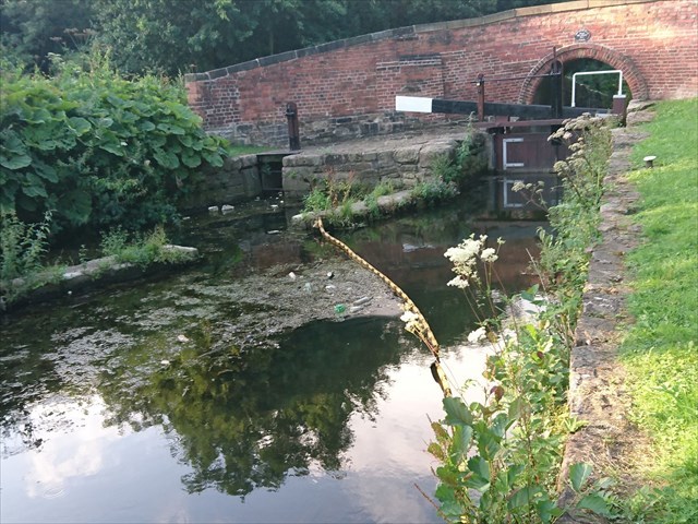
This is even more noticeable at the first Lock gate and weir where this cache is located. In order to attract wildlife such as fish and their predators, there needs to be oxygen in the water, but this gets used up if it becomes stagnant. Rivers have a constant moving supply of water and oxygen within it, and the turbulence of rapids and water falls helps mix up the water; this is obviously not the case with our 'tamed' canals though. The problem can usually be avoided by having at least a small amount of water flow, such as gates on overflows left slightly open, and the run off of water back into the river or ponds. There are plenty of fish in the canal now so this problem must have been alleviated. The other issue of stationery water can occur in winter when sub-zero temperatures do cause the canals to freeze, albeit only on the surface. There is usually still some flow of water and oxygen underneath and so the fish do survive. It is typically not solid enough to walk on either so don't try that. In contrast it is rare to see rivers frozen because the water keeps moving a lot more regularly than it does in canals. A frozen canal can make a very eerie noise if it is frozen and struck with a stone or stick; the sound resonates down the straights of the canal like a giant ghostly bell. Sound travels surprisingly well down these artificial channels, much as it does in a third type of canal (the ear canal)!
Original Earthcache Questions (only for fun, no need to email any answers):
- Describe the conditions of the canal today- how is the flow of water on the river before the split different to the flow of water on the canal after the nearby overflow or after the bridge? and state how it is running over this nearby overflow today, if at all.
- How deep is the canal in the middle typically?
- What are the problems of artificially held water in canals that need maintenance?- give one example of Proactive and one example of Reactive.
- Why are canals often near to rivers at the start and along the way?