Logging tasks
- Visit the location, tell me who is in your party that your are submitting answers for. Please answer next to each other. If one of you waits it may be deleted, and you need to submit your answers yourself.
- Can you spot any softer rock that is not lava rock under the basalt? or does the entire plateu appear to be basalt?
- Many sedementary rocks are laid in layers, and they break apart in those horizontal layers. Are these breaks horizonal or vertical?
- Does it appear to be one or a few large layers of basalt? or one? Can you make out a difference and what is it?
- Add a photo of you from the location or of an identifiable item (paper with trackable name). Posting a photo pulled from the internet, or photoshopped will result in instant deletion.
Intro
A few thousand years ago this valley was being cut by the local rivers, lava flows and floods changed this location to be quite different. This valley was cut over many thousands of years. looking like many of the mountain valleys around it. This one was a bit larger than many of the others.
Volcanic Period
About 400,000 years ago volcanoes were active in the area, and one from a nearby location erupted and a lava flow filled the valley. The freeway south of here climbs to the top of that flow and follows it southward.
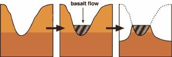
Figure Source Utah Geological Survey (http://geology.utah.gov/surveynotes/geosights/invertedtopo.htm
When it stopped flowing, much of the water would have flowed from the canyons from the east and west, and started to cut new valleys, one on both sides of the basalt flow. The deposits, and rock on those sides were much softer than the 50 feet of basalt rock that plugged the channel.
The plug was pulled
Jump forward many years, to about 14000 years ago. The waters of the great salt lake were growing, and south of here, were reaching a peak. Actually there was another location south of Cedar City, Utah, that was approaching a point where it may break, and start draining this inland sea. However this option would be far more catistrophic.
A large earthen dam had built up from sedements on both sides of the valley just south of here, south of Downey. When it broke, it was pretty quick, and a lot of water was released.. A wall of water crashed into this valley and those downstream for a period of weeks, water flowed from the Lake Bonnivilled, dropping the lake (that was 350 miles long and 200 miles wide) by 344 feet.
Water crashed through these canyons. 33,000,000 cubic feet per second tore down this channe. This eroded both sides around the lava flow even more. To compare that is 66 times the flow of the Mississippi, and nearly 700 times the normal flow of the snake ruver.
Results
The breach here may have been caused by that flood. From the southern arm of the lava flow, to this one it is broken through. Much of the water traveled through this gap. It could have been a thin strip that broke at that time.
Eventually the results are the hard lava top, leaves you with the bottom of the old valley above our heads. The softer rock eroding away.