Meandering Rivers:
Rivers flowing over gently sloping ground begin to curve back and forth across the landscape. These are called meandering rivers.
Meandering rivers erode sediment from the outer curve of each bend and deposit it on an inner curve further down stream. This causes individual bends to grow larger and larger over time.
Meandering river channels are not symmetrical. The deepest part of the channel is on the outside of each bend. The water flows faster in these deeper sections and this erodes material from the river bank. The water flows more slowly in the shallow areas near the inside of each bend. The slower water can't carry as much sediment and so it deposits its load on a series of point bars on the inside of these bends.
Oxbow Lakes:
Oxbow lakes form when a meander grows so big and loopy that two bends of the river join together. Once the meander bends join, the flow of water reduces and sediment begins to build up. Over time oxbow lakes will fill with sediment and can even disappear. The point where the two bends intersect is called a meander cut-off.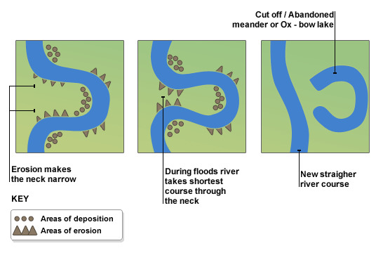
Billabongs:
Oxbow lakes have been forming in Australia for over 250 years. Well over. And so not surprisingly the indigenous inhabitants have another name for them.
They call them billabongs.
Questions:
At GZ there is a body of water. In accordance with GC rules you need to have attended the location after the time the EC was published to claim a find. Please message or email the answers to the first 2 questions to the CO. Please do not put these answers in your log. You may provisionally log a find prior to receiving a reply from the CO. Feel free to add any memories you have of this area to your log.
Question 1: What do you think this body of water is? Describe the features that support your view.
Question 2: How and when was it formed? Some research may be needed to find this out.
Go to the waypoint marked VIEWPOINT.
Question 3: Suggest some reasons why this body of water has not disappeared over time. What can you can see to support your explanation?
Question 4: Optional - post a picture of your GPS plus or minus yourself taken at or near to VIEWPOINT with the water in the background.
We'd like to acknowledge Freddo for his suggestion that this site needed an Earthcache.