Erawan Waterfall
This Earthcache is located in Erawan National Park for which an admission fee is required. Park admission and hours of operation can be found here
Erawan Waterfall is recognized as one of the most beautiful waterfalls in Thailand. Located in the Tenasserim Hills in Kanchanaburi Province, some 200 km northwest of Bangkok, Erawan has seven separate tiers and is part of a national park of the same name. Besides the waterfall, the park hosts a handful of limestone caves offering plenty of exploration opportunities to visitors.
น้ำตกเอราวัณเป็นที่รู้จักว่าเป็นหนึ่งในน้ำตกที่สวยที่สุดในประเทศไทย เอราวัณตั้งอยู่ในเขต Tenasserim Hills ในจังหวัดกาญจนบุรีซึ่งห่างจากกรุงเทพฯไปทางตะวันตกเฉียงเหนือประมาณ 200 กม. Erawan มี 7 ชั้นแยกเป็นส่วนหนึ่งของอุทยานแห่งชาติที่มีชื่อเดียวกัน นอกจากน้ำตกสวนสาธารณะยังมีถ้ำหินปูนมากมายที่ให้โอกาสในการสำรวจแก่ผู้มาเยือน
Logging Requirements:
To log this earthcache, please email the answers to the following questions at the same time as you log your find. If there is a problem with any of the answers. I will let you know. Found logs will be deleted if answers are not emailed at the same time.
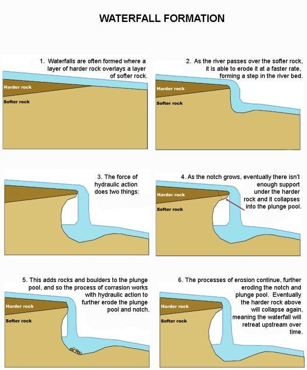
1) What type of rocks can you identify at the given coordinates? Does the rock types changes between the levels?
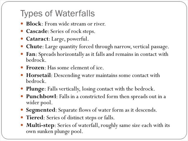
2) Using the waterfall classification guide above, what classification of waterfall do you believe this waterfall is? Does the classification changes between the levels?
3) Estimate the height of the waterfall (given coordinates) and how deep you think the plunge pool happens to be at the time of your visit (if this waterfall has one). Does it appear to be the rainy or dry season?
4) While exploring all 7 levels of the waterfall, describe difference between 7th level (top) and 1st level (bottom). Describe difference between height and widght. Is the water color different in those levels? If yes, why there is such a differences?
5) Take a photo of you (face showing is not mandatory) or a personal item from the location without revealing answers.
If you visit this cache as "team", your cache log needs to be attached with individual photo. Logs with the same photo for all "team" members are not permitted.
6)(Bonus) Which level is your favourite and why?.
ข้อกำหนดในการเข้าสู่ระบบ:
และตอนนี้งาน! หากต้องการบันทึกข้อมูลแผ่นดินไหวนี้โปรดส่งอีเมลถึงคำตอบสำหรับคำถามต่อไปนี้ในเวลาเดียวกับที่คุณบันทึกข้อมูลของคุณ หากมีปัญหากับคำตอบใด ๆ ฉันจะแจ้งให้คุณทราบ. พบบันทึกที่จะลบหากยังไม่ได้ส่งอีเมลตอบในเวลาเดียวกัน
1) หินประเภทใดที่คุณสามารถระบุได้ในพิกัดที่กำหนด? ชนิดของหินมีการเปลี่ยนแปลงระหว่างระดับหรือไม่?
2) คุณใช้น้ำตกในการจำแนกประเภทน้ำตกหรือไม่? การจัดหมวดหมู่มีการเปลี่ยนแปลงระหว่างระดับหรือไม่?
3) ประมาณความสูงของน้ำตก (ให้พิกัด) และคุณคิดว่าสระว่ายน้ำลึกที่สุดเท่าที่จะเป็นไปได้ในเวลาที่คุณเยี่ยมชม (ถ้าน้ำตกแห่งนี้มีที่) ดูเหมือนฤดูฝนหรือฤดูแล้ง?
4) ขณะสำรวจระดับน้ำตกทั้งหมด 7 ระดับให้อธิบายความแตกต่างระหว่างระดับ (ระดับบนสุด) และระดับที่ 1 (ด้านล่าง) อธิบายความแตกต่างระหว่างความสูงและความกว้าง สีน้ำมีความแตกต่างในระดับเหล่านี้หรือไม่? ถ้าใช่ทำไมมีความแตกต่างดังกล่าว?
5) ถ่ายภาพตัวเองด้วยอุปกรณ์ GPS จากใต้ท้องฟ้า?
6) (Bonus) ระดับไหนที่คุณชอบและทำไม?.
Good luck, and enjoy the views!
โชคดีและสนุกกับมุมมอง!