 |
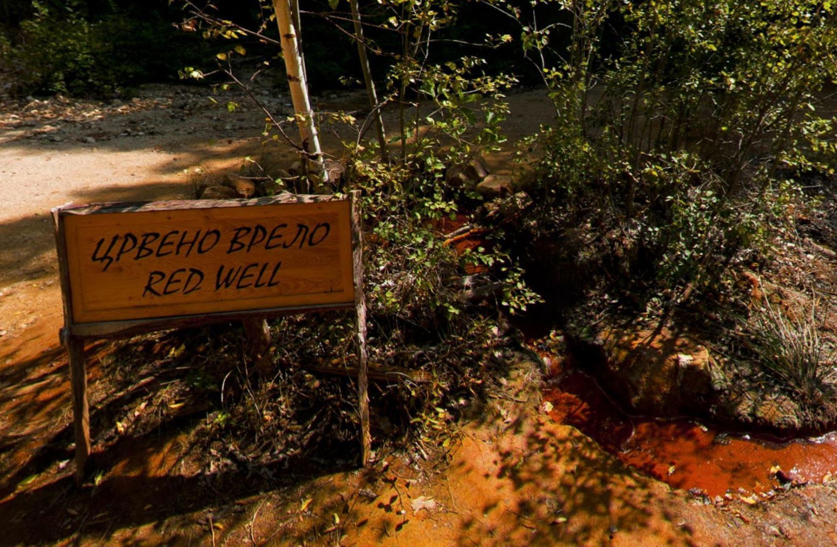
Red Well |
|
You are in Đavolja Varoš (Devil's Town) famous for his peculiar rock formations called earth pyramids or "towers". There are 202 soil figures in total, in different shapes and sizes, the height ranging from 2 to 15m, width from 0.5 to 3m, all having the stone cap on top. They are created as a result of a specific erosive process which lasts for centuries.
Another natural rarity in Đavolja Varoš are two springs of extraordinary properties and this EarthCache wants to point the attention of the visitors to them and in particular to the so called Red Well.
Waters of the Devil
Devil’s Water (Đavolja voda), which is located in the immediate vicinity of the soil figures, is a cold and extremely acid spring (pH 1.5) of high mineral concentration (15 g/l of water), springing out in “Devil’s Gully”. In comparison to drinking water, it is 10 to 1000 times richer in minerals (aluminum, iron, potassium, copper, nickel, sulfur).
Red Well (Crveno vrelo) is another spring located downstream, in the alluvial plain, 400 m away from the first spring. Its water (pH 3.5) is less acid and has a lower general mineral concentration (4.372 mg/l of water). Because of the flat terrain, its water overflows in a very thin layer and runs into a bed of the nearby yellow stream. Due to the oxidation of iron, which is contained in water in large amounts, an attractive red terrace in the form of a fan is created.
Iron (Fe) and water
Iron is the second most abundant metal in the Earth's crust with a share of approx. 6% and occurs in practically all soils and rocks. Elementary iron dissolves in water under normal conditions. By leaching and chemical solutions, iron compounds are also released into the spring water. In areas with deposits of iron oxide and in the vicinity of iron ore deposits, there is a lot of iron in the groundwater. Due to soil with low pH values and acidic groundwater, iron is released from the surrounding soil and rock layers.
Iron does not clearly alter in pure water or in dry air, but when both water and oxygen are present (moist air), iron corrodes. Its silvery colour changes to a reddish-brown, because hydrated oxides are formed.
Groundwater usually contains very little oxygen. In the case of oxygen deficiency, iron is mainly present in groundwater in the form of colorless iron (II) ions. If iron-containing groundwater comes into contact with the oxygen in the surface, the iron ions oxidize to the iron (III) oxide ("rust") then the brown coloring of the swelling is produced.
Water springs and their basic classification
A spring is any natural situation where water flows from an aquifer to the Earth's surface. It is a component of the hydrosphere.
Part of the water that falls in the form of precipitation on the surface flows over the surface and part of it seeps into the ground. The groundwater flows through porous or broken rocks down until it reaches the water table or an impermeable layer. Unless the water table is horizontal the water flows as well in lateral direction until it encounters the sloping impermeable layer. Leaking water and the water table may in some places get to the surface, we call such places as springs. The spring is a name for the seepage from which the water comes from the ground on the surface. The springs can also be below the water level in rivers, lakes or seas.
Groundwater can descend through permeable rocks and in the areas with lower surface it can flow freely. It can overflow to the surface in areas where it faces impervious rock, or it is pressed to the surface by pressure. According to this criteria , the springs are divided into descending and ascending.
Descending springs
They occur in places where the impermeable layer or water table is leaning in the direction of water seepage and the water flows out by gravity.
Subtypes of descending springs:
1) Ravine and valley spring: water flows slowly. Because of the drop of the surface in the area the surface is below the water table.
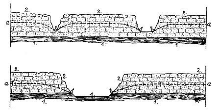 (1) impermeable layer, (2) permeable layer, (a) water table
2) Debris spring: water flows out slowly. The groundwater level is higher than the spring.
3) Stratified spring: water flows out at the bottom outcrop of sloping contact surface between impervious layers (2) and pervious cracked rock (3).
4) Overflowing spring: the spring is higher than the groundwater level. The water flows out slowly when the groundwater level reaches the spring.
Ascending springs
They occur in places where water rises opposite to the direction of gravity due to pressure (e.g. caused by gases) or hydrostatic pressure exerted by water, which is located above (the principle of communicating vessels).
Subtypes of ascending springs:
1) Layer spring: it is located higher than the underground water. The water flows out only when it rains, otherwise it does not have enough water.
2) Fault spring: the water spouts. The impermeable layer is disrupted. The water then comes to the surface against the direction of gravity, trying to balance the pressure.
Magnitude
Springs are also often classified by the volume of the water they discharge, called magnitude.
The scale for spring flow is as follows:
| Magnitude |
Flow (L/s) |
| 1st magnitude |
> 2800 L/s |
| 2nd magnitude |
280 to 2800 L/s |
| 3rd magnitude |
28 to 280 L/s |
| 4th magnitude |
6.3 to 28 L/s |
| 5th magnitude |
0.63 to 6.3 L/s |
| 6th magnitude |
63 to 630 mL/s |
| 7th magnitude |
8 to 63 mL/s |
| 8th magnitude |
< 8 mL/s |
| 0 magnitude |
no flow (sites of past/historic flow) |
TO LOG:
You can log immediately and send to me the answers to the below questions later. You can also add a picture of you near the spring or somewhere in Đavolja Varoš, this is not mandatory but appreciated.
Remember: your log will be deleted without notice if you don’t send any answer in an acceptable timeframe.
Questions:
- What is the type and subtype of the spring you see (choose the most probable alternative from the above mentioned examples) and why?
- Estimate the magnitude of the well.
- Describe the spring water (temperature, smell, colour, ...) and the soil composition (mud, sand, rocks, …) of the spring bottom.
- Diameter of the well.
- Using an iron strip, measure the quantity of iron in the water (because these strips are pretty expensive, this is not mandatory but the result it will surprise you and it’s an appreciated task).
- Aad a picture of you and your GPS.

 |
Crveno Vrelo |
|
Nalazite se u Đavoljoj Varoši poznatoj po svojim jedinstvenim kamenim formacijama nazvanim zemljane piramide ili “kule”. Tu se nalazi ukupno 202 zemljane figure različitih oblika i veličina, visinskog raspona od 2 do 15m, raspona u širini od 0.5 do 3m i sve imaju kamenu kapu na vrhu. Nastali su kao rezultat specifičnih erozivnih procesa koji traju vekovima.
Još jedna prirodna retkost Đavolje Varoši su dva izvora izuzetnih osobina i ovaj EarthCache želi da skrene pažnju posetilaca na njih, a posebno na onaj zvani Crveno Vrelo.
Đavolje vode
Đavolja voda, koja se nalazi u neposrednoj blizini zemljanih figura, je hladan i izuzetno kiseo izvor (pH 1.5) visoke mineralne koncentracije (15 g/l vode), koja izvire u “Đavoljoj jarugi”. U poređenju sa pijaćom vodom, ova je 10 do 1000 puta bogatija mineralima (aluminijum, gvožđe, kalijum, bakar, nikal, sumpor).
Crveno vrelo je drugi izvor koji se nalazi nizvodno, u aluvijalnoj ravni, 400m dalje od prvog izvora. Njegova voda je manje kisela (pH 3.5) i ima manju koncentraciju minerala u sebi (4.372 mg/l vode). Zbog ravnog terena, njegova voda se preliva u veoma tankom sloju i ulazi u korito obližnjeg žutog potoka. Usled oksidacije gvožđa, koji se u velikim količinama nalazi u vodi, stvorena je atraktivna crvena formacija u obliku lepeze.
Gvožđe (Fe) i voda
Gvožđe je drugi najrasprostranjeniji metal u kori Zemlje sa udelom od približno 6% i koji se javlja u skoro svakom tlu i kamenu. Osnovno gvožđe se rastvara u vodi u normalnim uslovima. Izlivanjem jedinjenja gvožđa takođe dolaze u izvorsku vodu. U područjima sa naslagama oksida gvožđa i u blizini naslaga gvozdene rude, u podzemnim vodama postoji puno gvožđa. Zbog tla sa niskim pH vrednostima i kiselim podzemnim vodama, gvožđe se oslobađa iz okolnog zemljišta i slojeva stena.
Gvožđe se ne menja na čistoj vodi ili na suvom vazduhu, ali u slučaju kad su i voda i kiseonik prisutni (vlažan vazduh), gvožđe korodira. Njegova srebrna boja se menja u crvenkasto-braon, zato što se formiraju hidridni oksidi.
Podzemne vode obično sadrže malo kiseonika. U slučaju manjka kiseonika, gvožđe se uglavnom javlja u podzemnim vodama u formi bezbojnih gvožđe (II) jona. Ukoliko podzemne vode, koje sadrže gvožđe, dođu u kontakt sa kiseonikom na površini, joni gvožđa oksidiraju u gvožđe (III) oksid (“rđu”) i tada se javlja braon boja toka.
Izvori vode i njihove osnovne klasifikacije (podele)
Izvor je mesto u kojoj voda prolazi od vodonosnog sloja do površine zemlje. To je komponenta hidrosfere.
Deo vode koji u obliku padavina padne na zemlju, teče njenom površinom, dok se deo sliva u zemlju. Voda teče kroz porozne i naprsle stene sve dok ne stigne do gornje granice podzemne vode ili nepropusnog sloja. Osim ako je gornja granica podzemne vode horizontalna, tada voda takođe teče bočno sve dok ne dođe do kosog nepropusnog sloja. Propuštanje vode i gornja granica podzemne vode na nekim mestima mogu da dodju do površine zemlje, takva mesta nazivamo izvorima vode. Izvor je naziv za to propustanje kada voda dolazi iz zemlje na površinu. Izvori takođe mogu biti i ispod nivoa vode u rekama, jezerima i morima.
Podzemne vode se mogu spustiti kroz propusne stene i slobodno teći. Mogu se preliti na površinu u oblastima na kojima naiđu na neprousno kamenje, ili gde su istisnuti na površinu usled pritiska. Prema ovim kriterijumima, izvori su podeljeni na silazne i uzlazne.
Silazni izvori
Javljaju se na mestima gde se nepropusni slojevi ili gornja granica podzemne vode naginju ka smeru propuštanja vode i voda izvire uz pomoć gravitacije.
Podtipovi silaznih izvora:
1) Izvori uvala i dolina: voda teče lagano. Pad površine u ovom području je ispod gornje granice podzemne vode.
(1) nepropusni sloj, (2) propusni sloj, (a) gornja granica podzemne vode
2) Ruševine izvori: voda izvire polako. Nivo podzemne vode je viši od nivoa izvora.
3) Kontaktni izvori: voda izvire na dnu kosih kontaktnih površina između nepropusnih slojeva (2) i prohodnih ispucalih stena (3).
4) Prelivni izvori: izvor je viši od nivoa podzemne vode. Voda izvire polako kada nivo podzemne vode dođe do izvora.
Uzlazni izvori
Se javljaju na mestima gde se voda podiže suprotno pravcu gravitacije usled pritiska (npr. izazvana gasovima) ili hidrostatičkim pritiskom koji vrši voda koja se nalazi iznad (zakon spojenih sudova).
Podtipovi uzlaznih izvora:
1) Slojeviti izvori: nalaze se na većoj visini nego podzemne vode. Vode izviru jedino kada pada kiša, u suprotnom nemaju dovoljno vode.
2) Grešni izvori: vodeni mlazevi. Nepropusni sloj je oštećen. Tada voda dolazi na površinu suprotno pravcu gravitacije, pokušavajući da izjednači pritisak.
Jačina
Izvori su često podeljeni prema količini vode koju ispuštaju, odnosno izdašnosti.
Skala za protok izvora je sledeća:
| Jačina |
Protok (L/s) |
| 1. jačina |
> 2800 L/s |
| 2. jačina |
280 to 2800 L/s |
| 3. jačina |
28 to 280 L/s |
| 4. jačina |
6.3 to 28 L/s |
| 5. jačina |
0.63 to 6.3 L/s |
| 6. jačina |
63 to 630 mL/s |
| 7. jačina |
8 to 63 mL/s |
| 8. jačina |
< 8 mL/s |
| 0 jačina |
nema protoka (područje starih tokova) |
Da bi ste logovali:
Možete logovati keš odmah i kasnije mi poslati odgovore na dole navedena pitanja. Takođe, možete dodati fotografiju vas u blizini izvora ili negde u Đavoljoj Varoši, ovo nije obavezno ali će biti cenjeno.
Zapamtite: vaš log će boti izbrisan ukoliko mi ne pošaljete odgovore u prihvatljivom vremenu.
Pitanja:
- Koji je tip i podtip izvora koji vidite (izaberite najverovatniju alternativu od gore navedenih primera) i zašto?
- Procenite izdašnost/jačinu izvora.
- Opišite vodu izvora (temperatura, miris, boja, ...) i sastav tla (blato, pesak, kamenje, …) dna izvora.
- Prečnik izvora.
- Koristeći traku za gvožđe, izmerite količinu gvožđa u vodi (s obzirom na to da su ove trake izuzetno skupe, ovo nije obavezno, ali rezultat će vas iznenaditi i zadatak će se ceniti).
- Dodajte fotografiju sebe i GPS-a.

