Al visitar las magníficas esculturas de Chillida “El Peine del Viento”, descubrimos esta maravilla geológica que queda justo al lado y que pasa indiferente ante los ojos de muchos turistas, cuya atención queda acaparada por el grandioso conjunto escultórico y las vistas hacia la bahía. Algo, que sin duda conmueve e impresiona. Con este earthcaché, queremos complementar el paseo de los visitantes hacia aquí, que pueden disfrutar además de estas formaciones geológicas al pasear a lo largo de la Playa de la Concha, tanto en la misma playa como en la ladera de la Isla de Santa Clara ubicada en dicha bahía.
PEINANDO LA TIERRA
La ciudad de Donosti o San Sebastián se ubica en la zona de máxima curvatura del denominado Arco Plegado Vasco. Geológicamente hablando, esta ciudad está asentada sobre materiales de las edades Paleozóica, Mesozóica, Terciaria y Cuaternaria.
Los materiales tipo Flysch del Cretácico superior están muy bien representados en estas costas cantábricas constituyendo amplias zonas y estando representado por una sucesión de flysch de diversos materiales: calizas, areniscas y margas. Pueden diferenciarse dos tramos: el más inferior, de naturaleza calcáreo-arcillosa (flysch calcáreo), y otro superior de características flyschoides (flysch detrítico-calcáreo). El flysch detrítico-calcáreo está constituido por una alternancia de calizas arenosas, margas y areniscas estratificadas en bancos de varios cm o dm de espesor.
Pero.. ¿qué es un FLYSCH?
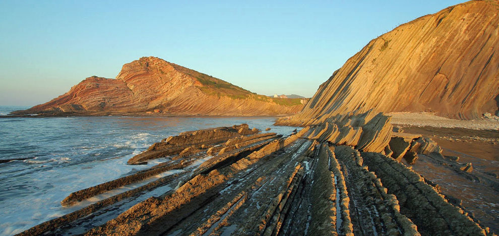
Los Flysch (que en alemán quiere decir fluir o deslizarse) son formaciones rocosas de origen sedimentario compuestas por una alternancia rítmica de capas de rocas duras (calizas, pizarras o areniscas) intercaladas con otras más blandas (margas y arcillas) que favorecen la erosión diferencial, desgastando más fácilmente las capas blandas y dejando expuestas las capas duras. Estas capas duras también son erosionadas lentamente pero siguen proporcionando protección a las capas blandas durante mucho tiempo.
El origen de la formación de estos conjuntos de capas es el acúmulo sedimentario de materiales de diferente densidad en el fondo oceánico, de forma laminar. Debido a diferentes fenómenos geológicos, han aflorado a la superficie donde son erosionados por la acción del viento y el agua del mar.
El afloramiento de estas capas rocosas a la superficie se debió a la colisión de las placas tectónicas Ibérica y Europea. Como resultado quedaron expuestos materiales que contienen información de más de 50 millones de años de historia de la Tierra, recorriendo periodos del Cretácico Superior y del Terciario. En ellas puede encontrarse información biológica a través de su contenido en micro y macrofósiles e incluso información sobre cambios ambientales y climáticos. El grosor de cada capa habla de la duración de cada periodo representando cada una aproximadamente 10.000 años. Las capas duras corresponden a periodos fríos y las blandas a periodos cálidos.
El interés del Flysch, por lo tanto, no sólo es estético, sino que permite a los geólogos conocer más de 60 millones de historia de la Tierra con sus grandes hitos como la extinción de los dinosaurios, acaecida al final del Cretácico, o el gran calentamiento climático del inicio del Eoceno.
De este modo se han creado paisajes tan espectaculares como el que puede verse en diferentes puntos de la costa vasca. Algunos de estos tramos, como el de 13 km que se encuentra entre Mutriku y Zumaia, pasando por el municipio de Deba, han sido reconocidos por la Unión Internacional de Ciencias Geológicas (IUGS) y la UNESCO, declarándolos uno de los grandes afloramientos geológicos del planeta. Su importancia científica y paisajística ha hecho que esta zona forme parte del Geoparque de la costa Vasca declarando la zona Deba-Zumaia Biotipo Litoral Protegido (2009). Además, la zona permite saborear al mismo tiempo la excelente gastronomía de la zona, conocer su patrimonio monumental o bañarse en algunas de sus estupendas playas.
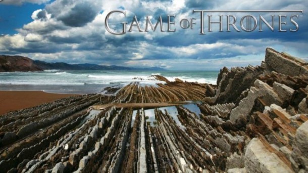
Estas interesantes estructuras geológicas son tan importantes que hasta series de televisión han seleccionado estos paisajes para rodar algunas de sus más emblemáticas escenas. Éste es el caso de la serie “Juego de Tronos” con las costas de la localidad vasca de Zumaia.
Debéis saber que si hay temporal, al encontrarse esta zona muy cerca de la costa, es muy probable que esté cortado el acceso a la misma (¡no pasar la linea de seguridad!). Si no lo está, tendréis que extremar las precauciones.
El caché:
Para registrar este caché deberás contestar a las siguientes preguntas:
Coordenadas iniciales. N 43 19.287 W 002 00.318
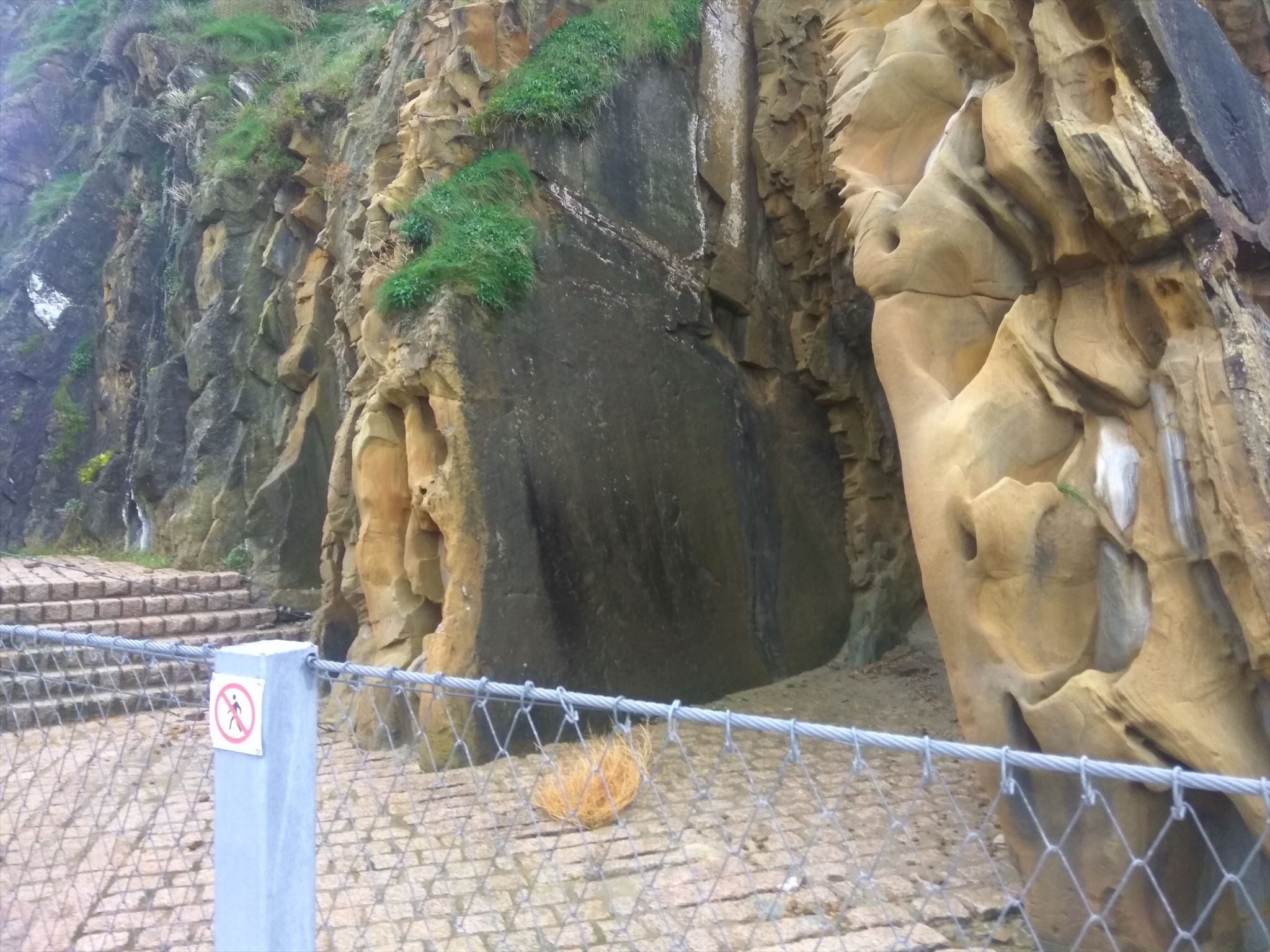
Las coordenadas iniciales te sitúan muy cerca del conjunto escultórico de Chillida “El peine del viento”. Localiza la zona de la foto y observa los Flysch que se encuentran entre las dos grandes capas de la siguiente foto. La zona puede encontrarse vallada debido a pequeños desprendimientos de rocas que ha habido recientemente en esa ladera del monte Igueldo.
Cuestión 1. Según tus propias palabras ¿Qué es un flysch?.
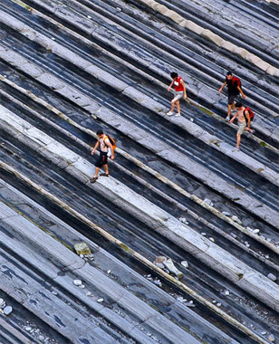
Cuestión 2. Los flysch que se encuentran entre estas dos grandes capas son de diferente grosor. ¿Qué grosor tienen las capas más finas y las más anchas? Elige entre 5, 15 y 50 cm.
Cuestión 3. ¿Qué ángulo forman, en su gran mayoría, dichas capas con el suelo (90º=vertical)?. ¿Hacia qué lado existe inclinación?. ¿Derecha o izquierda?.
Cuestión 4 (obligatorio a partir de 20 de agosto de 2021). Haz una foto en el lugar (sin revelar ninguna de las cuestiones anteriores) y adjúntala en tu log con algún elemento que te identifique como geocácher (nick en un papel, GPS, avatar, logo de geocaching, mascota, etc).
IMPORTANTE: Antes de “loggear” este Earthcache, por favor, enviadnos un mensaje con las respuestas a las preguntas anteriormente formuladas. SI NO SE CUMPLE ESTO EL LOG SERÁ BORRADO. No es necesario esperar a nuestra respuesta de aprobación para hacer el “found”, pero SÍ ES NECESARIO enviar las respuestas y subir la foto al log.
English version
When visiting the magnificent sculptures of Chillida "El Peine del Viento” (The comb of the wind), we discover this geological wonder that is right next to it but that passes indifferently before the eyes of many tourists whose attention is captured by the great sculptures and the view of the bay. It is a view that touches and impress. With this Earthcache we want to complement the walk of the visitors to the area, who can enjoy these geological formations when walking along the Playa de la Concha, both on the beach itself and on the slope of Isla de Santa Clara located on the bay.
PEINANDO LA TIERRA (“COMBING” THE EARTH)
The city of Donosti or San Sebastián is located in the area of maximum curvature of the so-called Basque Folded Arch. Geologically speaking, this city is based on materials from the Paleozoic, Mesozoic, Tertiary and Quaternary ages.
The Flysch type materials of the Upper Cretaceous are very well represented in these Cantabrian coasts, constituting large areas and being represented by a succession of flysch of different materials: limestones, sandstones and marls. Two sections can be differentiated: the lowermost one, of calcareous-clayey nature (calcareous flysch), and the upper one with flyschoid features (detritic-calcareous flysch). The detritic-calcareous flysch is constituted by an alternation of sandy limestones, marls and sandstones stratified in banks of several cm or dm in thickness.
But .. what is a FLYSCH?
The Flysch (that in German means to flow or to slide) are rock formations of sedimentary origin composed by a rhythmic alternation of layers of hard rocks (limestone, slates or sandstones) interspersed with other softer ones (marls and clays) that favors the differential erosion, more easily abrading the soft layers and leaving the hard layers exposed. These hard layers are also slowly eroded but still provide protection to the soft layers for a long time.
The origin of the formation of these sets of layers is the sedimentary accumulation of materials of different density in the ocean floor, in a laminar form. Due to different geological phenomena, they have surfaced on the surface where they are eroded by the action of wind and sea water.
The outcrop of these rock layers to the surface was due to the collision of the Iberian and European tectonic plates. As a result, materials containing information from more than 50 million years of Earth's history were exposed, covering periods of the Upper and Tertiary Cretaceous. In them you can find biological information through its content in micro and macro-fossils and even information on environmental and climatic changes. The thickness of each layer speaks of the duration of each period, each representing approximately 10,000 years. The hard layers correspond to cold periods and the soft ones to warm periods.
The interest of the Flysch, therefore, is not only aesthetic, but allows geologists to know more than 60 million Earth history with its great landmarks such as the extinction of the dinosaurs, which occurred at the end of the Cretaceous, or the great climatic warming of the beginning of the Eocene.
In this way, landscapes as spectacular as those that can be seen in different parts of the Basque coast have been created. Some of these stretches, such as the 13 km stretch between Mutriku and Zumaia, passing through the municipality of Deba, have been recognized by the International Union of Geological Sciences (IUGS) and UNESCO, declaring them one of the great geological outcrops of the planet. Its scientific and landscape importance has made this area part of the Geopark of the Basque Coast, declaring the Deba-Zumaia Protected Litoral Biotype zone (2009). In addition, the area allows you to taste at the same time the excellent cuisine of the area, know its monumental heritage or bath in some of its wonderful beaches.
These interesting geological structures are so important that even television series have selected these landscapes to shoot some of their most emblematic scenes. This is the case of the series "Game of Thrones" with the coasts of the Basque town of Zumaia.
You should know that if there is a storm, since this area is very close to the coast, it is very likely that the access to this place will be cut off (do not trespass the safety line!!). If it is not, please, you will have to be very careful.
The cache:
To register this cache you must answer the following questions:
Initial coordinates. N 43 19.287 W 002 00.318
The initial coordinates places you very close to Chillida's sculpture "El peine del viento". Locate the area of the photo and see the Flyschs that are between the two large layers of the photo. The area can be fenced due to small rockfalls that have recently occurred on that slope of Mount Igueldo.
Question 1. What is a flysch in your own words?.
Question 2. The flyschs between these two large layers are of different thickness. How thick are the thinnest and widest layers? Choose between 5, 15 and 50 cm.
Question 3. What angle do most of these layers form with the ground (90º=vertical)? Which side are they inclined to? Right or left?
Question 4 (compulsory since august 20th, 2021). Take a picture on site (with no spoilers for the questions above) and attach it to your log. The picture must include something that identifies you as a Geocacher (like your nickname, your GPS, your avatar, a geocaching logo, geocaching pet, etc.).
IMPORTANT: Before "logging" this Earthcache, please send us a message with the answers to the questions previously formulated. If this is not fulfilled THE LOG WOULD BE DELETED. It is not necessary to wait for our approval response to make the "found", but IT IS REQUIRED to send the answers and upload the picture.