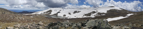
There have been four major geological ice events that have helped shaped the Australian Alps during the last 70,000 years. These events saw glacial ice forming, with the last ice age occurring around 20,000-22,000 years ago. Although not extensive, evidence of these glacial events within the Kosciuszko National Park can be seen above 1500 metres in the form of cirque lakes. On the southern flank of Australia's highest peak of Mount Kosciuszko, lies the highest cirque lake in Australia, Lake Cootapatamba, with an elevation of 2048 metres.

Cirque Lakes
Formed by glaciers, cirque lakes are basically a glacier-carved bowl or amphitheater in the mountain. Typically found on the highest, most sheltered mountain face, the cirque is formed at the head of a glacier which digs out these semicircular basins as the glacier moves down the mountain. After the glacier recedes, the basins may later fill up with water and thus form a cirque lake.
Moraines
A moraine can be described as ridges of ground up rock and other debris dumped along the sides or the tongue of a melting glacier. Sometimes these moraines act as natural dams in valleys by forming moraine deposits which can be categorised into the following types:
- Lateral moraines - parallel ridges of debris deposited along the sides of a glacier
- Ground moraines - till-covered areas with irregular topography and no ridges, often forming gently rolling hills or plains
- End or terminal moraines - ridges of unconsolidated debris deposited at the snout or end of the glacier
- Recessional moraine - often observed as a series of transverse ridges running across a valley behind a terminal moraine
- Medial moraine - a ridge of moraine that runs down the center of a valley floor
- Supraglacial moraines - created by debris accumulated on top of glacial ice
- Washboard moraines - known as minor or corrugated moraines, are low-amplitude geomorphic features caused by glaciers
- Veiki moraine - a kind of hummocky moraine that forms irregular landscapes of ponds and plateaus surrounded by banks
Getting to the earthcache:
The preferred method is to make your way to Thredbo Village, then catch the Kosciuszko Express chairlift from Valley Terminal to the top of Thredbo Ski resort. At the top of the resort follow the Kosciuszko Walk towards Mount Kosciuszko until you reach the earthcache at the Lake Cootapatamba Lookout (3.8km one way).
An alternate route is to start at Charlotte Pass and walk along the Summit Walk towards Rawsons Pass. At Rawsons Pass follow the Kosciuszko Walk back towards Thredbo for 800 metres to the Lake Cootapatamba Lookout (8.4km one way). During the summer months you can also ride a bike from Charlotte Pass to Rawsons Pass and walk the remainder of the distance to the lookout.
PLEASE NOTE: Make sure you check the current weather conditions and forecast before you set off. Weather in the Snowy Mountains can change quickly and you MUST be prepared.
Earthcache requirements:
In order to log this earthcache you must visit the Lake Cootapatamba lookout and answer the following questions. You do not have to wait for a reply before logging your find. I attempt to reply to all e-mails submitting answers and, if there are any problems I will contact you to obtain more information.
- From your observations of the lake from the lookout, describe what you see and include in your answer the type of moraine that helped form the lake.
- What is so special about the water in the lake? (see NOTE below)
- What is the biggest problem facing the glacial lakes in Kosciuszko National Park? (see NOTE below)
The answers to these questions should not be included in your log. Please send the answers to me via e-mail. You may choose to use the new message centre if you wish.
NOTE: The original information sign at the lookout is missing, but a close look at the cache gallery will reward you with some fruitful data which you may find of use for Question 2&3.
Optional (but not required): please take a photograph of your GPS at the Earthcache and post this in your log. This is not required, but would be appreciated.
Some more interesting facts:
- Local aboriginals call this waterhole by the name of Kau-oola-patamba, which means the place where the eagle drank.
- The red painted Cootapatamba Hut can be seen from GZ (approximately 1.9km on bearing 220°). This alpine hut was built by the Snowy Mountains Authority (SRA) and is for emergency shelter only.
References:
Permission was granted from the National Parks and Wildlife Service (Office of Environment and Heritage) to place this EarthCache within the National Park.
Did you know that NSW has a geocaching association? Geocaching NSW aims to enhance and improve the activity of geocaching and holds regular events where geocachers meet to enjoy their common interests. Visit the association website here.