A small geocache is hidden somewhere at TROBO aka Akagamiyama Mountain. TAROBO is an isolated rocky mountain that used to be a part of gigantic caldera that was formed by volcanic activities in Cretaceous period 145〜66Million years ago . This 6-stage multi-cache will guide you through wonderful viewing points of TAROBO.
INITIAL STAGE: N 35° 06.982' E 136° 10.994'
Your adventure starts at the posted coordinates. Your first task is to climb all the stairs up to STAGE 3 and keep counting the number of steps N. In the end, you have to select the correct (or closest) number N.
STAGE 2: N 35° 07.072' E 136° 10.957'
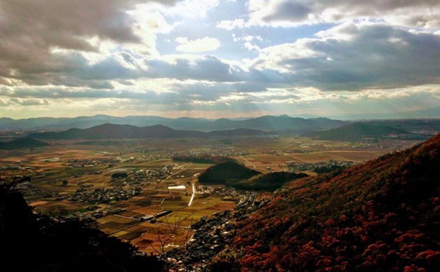
Here is a nice observatory to take a break. After having enjoyed the panoramic view, let's move on up to the STAGE 3. You may be able to find a hint to the number N, too.
STAGE 3: N 35° 07.085' E 136° 10.898'
Now you have come up to the TAROBO shrine main hall. How many steps N have you counted? Select the closest number N from the following numbers, 540, 640, 740, 840, or 940:
N=[___].
Next, find the following sentence on a guide board:
『平成AB年C月DE日指定
阿賀神社の鎮座する赤神山(あかがみやま)をはじめ湖東平野に散在する山々は、中生代白亜紀(およそFGH年前)の火山活動でできたと考えられており「湖東カルデラ」と呼ばれている。』
English Translation: Designated on Heisei AB year C month DE day.
Those mountains scattered in Koto Plain, including this Akagamiyama mountain, were resulted from the volcanic activities in Mesozoic Cretaceous period (approximately FGH years ago) and called "Koto Caldera".
Identify the numbers A,B,,, through H written by Chinese numerals:
A=[___], B=[___], C=[___], D=[___], E=[___], F=[___], G=[___], and H=[___],
where you can convert Chinese to Arabic numerals as given below.
〇:0, 一:1, 二:2, 三:3, 四:4, 五:5, 六:6, 七:7, 八:8, 九:9, 十:10, 百:100, 千:1000, 万:10000
Calculate following numbers:
P=H/G=[___], J=C-A=[___], K=E-D=[___], L=D+E=[___],
M=A+L=[___], Q=P-E=[___], R=A+F=[___], and U=N/(P*A)-(M*B)=[___]
STAGE 4: N 35° 07.KRJ' E 136° 10.RJQ'
Checker to validate STAGE 4 coordinates:

From here, you will enter the hiking trail leading to the final location.
STAGE 5: N 35° 07.AUM' E 136° 10.QQU'
Checker to validate STAGE 5 coordinates:

Here, find a sign post indicating three destinations “箕作山山頂( X km) ”, “赤神山( Y km)”, and “太郎坊宮( Z km)”. Identify the three numbers X, Y and Z:
X = [___], Y = [___] and Z = [___].
Obtain S and T as follows:
S=(Y+Z)*P=[___], and T=J + (Z-Y)*P=[___].
FINAL LOCATION: N 35° 07.EKD' E 136° 10.QST'
Checker to validate FINAL coordinates:

First, enjoy the wonderful panorama over the Koto plain 湖東平野 beyond which you can observe Lake Biwa 琵琶湖 and Mt. Hiei 比叡山 to name a few. The cache is a small plastic container with a screw top. It is well hidden in a place protected from rain water. A flashlight may be useful. Be careful not to trip and slip while searching it.
ENJOY YOUR HUNT!