Visitando el espectacular Parque Natural de las Hoces del río Riaza nos detenemos a observar las peculiaridades de este paisaje tan interesante desde el punto de vista geológico. Con este Earthcaché queremos mostrar a los geocachers este magnífico paraje y que así puedan aprender algo más de la geología del terreno.
CORTADOS EN LAS HOCES DEL RÍO RIAZA
El río Riaza ha excavado en las duras rocas calizas de los páramos segovianos uno de los mayores conjuntos de hoces, cañones, acantilados y desfiladeros que se pueden contemplar en el interior de la Península Ibérica.
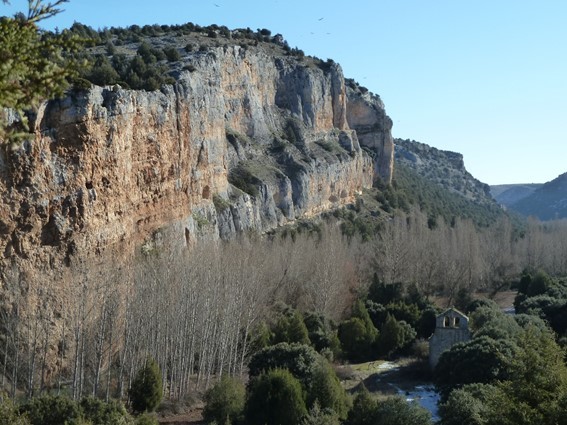
Las hoces del río Riaza se han formado por el trabajo erosivo que el río ha ido ejerciendo sobre los materiales por los que discurre modelando un valle de paredes verticales rematado en su parte superior por un relieve plano que se conoce como páramo.
Los elementos más llamativos de este paisaje son la presencia de meandros y cortados. Los meandros son esas curvas amplias que forma el río en su circular divagante. El agua busca las zonas más favorables para fluir aunque con el paso del tiempo esos meandros se van perdiendo para encontrar el agua un camino más corto y longitudinal que aproveche al máximo la energía acumulada.
Los cortados, por su parte, se han formado por la erosión lineal del cauce. El río ha ido excavando los cortados provocando desprendimientos que han ido ensanchando el valle con el paso de los años.
¿Qué son los CORTADOS?
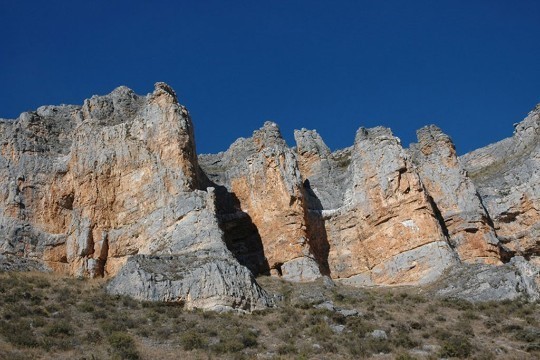
Los cortados son paredes verticales que descienden desde la altura de los páramos hasta el fondo del cañón. Se caracterizan por su poca tierra y escasez de agua que junto a su inaccesibilidad da lugar a un hábitat muy diferente al de otros lugares.
Desde entonces la erosión junto a los periodos de expansión y contracción de masas glaciares han ido moldeando las montañas y valles hasta conseguir el paisaje que podemos observar actualmente mediante la acumulación de sedimentos en forma de terrazas y lechos fluviales.
La formación de los cortados consta de varias etapas que se detallan a continuación y que se muestran en el siguiente dibujo:
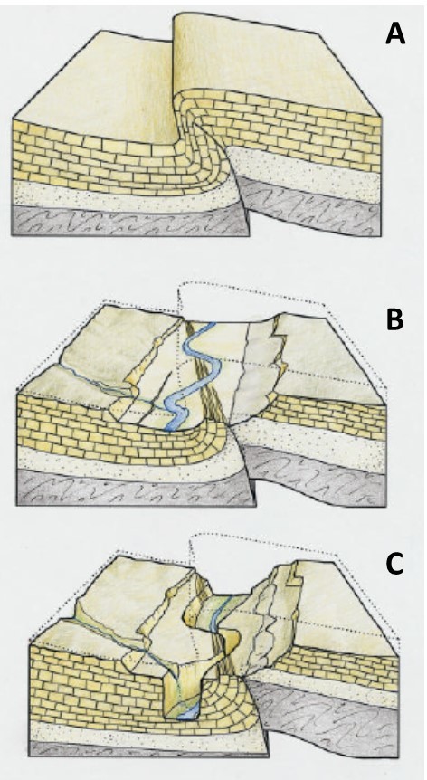
A: Durante la orogenia alpina (etapa de formación de montañas producida durante el Cenozoico cuando el continente africano chocó contra Eurasia) se formó un gran pliegue en forma de rodilla en las calizas cretácicas.
B: El río erosiona la zona de máxima curvatura del pliegue, denominada charnela, al ser la más fracturada, formando un paleovalle rectilíneo en dirección ligeramente oblicua al pliegue.
C: Se produce el rápido encajamiento del cañón en el lecho del paleocauce dejando grandes paredes verticales a ambos lados del río.
En los cortados abundan las oquedades, grietas y resaltes lo que hace que sea el lugar ideal para el establecimiento de aves rapaces. Cerca de los lugares de nidificación, y debido a la gran cantidad de excrementos de las aves, se pueden encontrar especies vegetales nitrófilas (que crecen en sustratos ricos en nitrógeno) como zapatitos de la Virgen, pumilo, hiedra o asplenio, estos últimos buscando el agua entre las grietas.
En las repisas puede encontrarse algo más de tierra fértil y la vegetación es de mayor envergadura pudiendo encontrarse arbustos y arbolillos como el guillomo, cornicabra, espino negro, higueras y mostajos y allí donde es posible puede encontrarse hierba sobre las rocas.
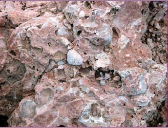
Los cortados de Peña Rubia y Peña Portillo están formados por conglomerados terciarios, de origen continental. Estas rocas están compuestas por cantos redondeados de diferentes tamaños y de diferente composición y unidos entre sí por un cemento carbonatado.
PARQUE NATURAL
Declarado Parque Natural el 21 de diciembre de 2004 cuenta con una superficie total de 5.184 ha y se encuentra en las tierras más orientales de la provincia de Segovia, cerca de Soria y Burgos. Los municipios de Montejo de la Vega, Maderuelo y Valdevacas de Montejo aportan parte de su territorio a este parque.
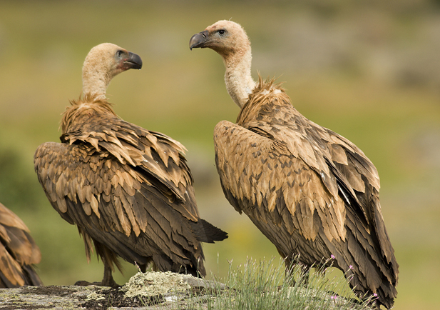
Por otra parte, desde 1989 este parque es Zona de Especial Protección para Aves (ZEPA) y es que, además de su espectacular paisaje, en este solitario espacio geográfico la presencia de cortados calizos, con abundantes repisas y oquedades de diversos tamaños permite el asentamiento de una importante concentración de aves rapaces entre las que destacan alrededor de 200 parejas de buitres leonados. Además, el embalse de Linares del Arroyo se convierte todos los años en la principal área provincial para la invernada de diferentes especies de aves acuáticas.
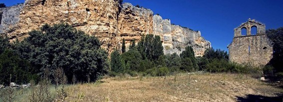
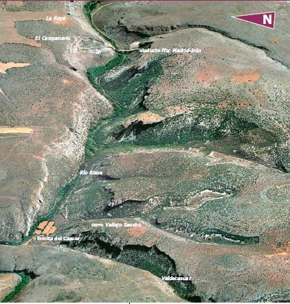
En cuanto a la vegetación que allí se puede encontrar, es principalmente esteparia, con manchas de arbolado adaptado a la continentalidad del clima (encinas y quejigos). Las laderas y escarpes rocosos, por su parte, están cubiertos por bosques de sabina albar, árboles que son auténticos fósiles vivientes de la época terciaria. En un ensanchamiento del cañón aparecen situados los solitarios restos románicos del convento de Casuar.
El río Riaza constituye el eje vertebral de este cañón pudiéndose distinguir tres zonas estructuralmente diferenciadas:
- La primera zona sería la que va desde Maderuelo hasta la presa de Linares del Arroyo con un paisaje dominado por las aguas remansadas del río el cual se encuentra embalsado desde 1951.
- Entre la anterior presa y el arroyo de Vadecasuar se encuentra la zona más espectacular del parque. Con una longitud de 5,5 km el río se encaja en un barranco angosto flanqueado por paredes calizas formando un cañón calcáreo de hasta 150 m de profundidad y entre 200 y 300 de anchura. En lo alto de los cortados rocosos anidan las aves rapaces que son las protagonistas de este espacio natural.
- En el último tramo, hasta Montejo de la Vega, el paisaje se vuelve más suave estando las aguas del río acompañadas en su fluir por una fértil vega.
Este espacio natural es poseedor de la Carta Europea de Turismo Sostenible concedida por la Federación EUROPARC (que agrupa a los espacios naturales protegidos de Europa), por las excelentes iniciativas que se desarrollan para dinamizar el medio rural y por sus eficientes sistemas de gestión y control de visitas, entre otros aspectos.
Para poder visitar este parque natural y disfrutar al máximo de las posibilidades que ofrece es recomendable visitar la CASA DEL PARQUE, situada en Montejo de la Vega. Allí podrás obtener toda la información necesaria para poder interpretar adecuadamente todos los misterios de la naturaleza que allí se ofrecen.
Como todo espacio protegido la visita a este Parque Natural tiene ciertas restricciones para su adecuada conservación. Como en otros espacios naturales protegidos es necesario caminar sin salirse de las sendas y caminos, no tirar basura ni hacer ruido, no acampar ni hacer fuego, no recoger plantas, piedras o animales, es decir, hacer todo lo posible para que no queden huellas de tu presencia.
Además, entre el 1 de enero y 31 de julio, has de contactar con la Casa del Parque, bien en su ubicación en Montejo de la Vega, bien a través de su correo electrónico cp.riaza@patrimonionatural.org para poder conseguir el permiso necesario para poder acceder a dicho Parque. El número máximo de personas por grupo es de 10. El resto del año el Parque puede ser visitado libremente.
El caché:
Para registrar este caché deberás contestar a las siguientes preguntas:
Coordenadas iniciales. N 41 32.788 W 003 36.181
Las coordenadas iniciales te sitúan delante de un cartel informativo en una parte elevada desde donde se pueden observar claramente los cortados de las Hoces del río Riaza.
Cuestión 1. Define con tus propias palabras ¿Qué es un cortado en geología?. ¿De qué tipo de roca se componen principalmente?
Cuestión 2. ¿Cómo se denomina la zona de máxima curvatura, zona más fracturada, donde se forma el pliegue en forma de rodilla que dará lugar, posteriormente, a los cortados?
Cuestión 3. Desde el punto en el que te encuentras se pueden ver algunos de los cortados de las Hoces. ¿Cómo son estos cortados, totalmente verticales o pueden verse terrazas en ellos?
Cuestión 4 (opcional). Hazte una foto en el lugar (sin revelar ninguna de las cuestiones anteriores) y envíala junto con las respuestas a las demás cuestiones.
IMPORTANTE: Para registrar este Earthcache, por favor, enviadnos un mensaje con las respuestas a las preguntas anteriormente formuladas. Si no se cumple esto, el log podría ser borrado. No es necesario esperar a nuestra respuesta de aprobación para hacer el “found”, pero sí es necesario enviar las respuestas.
English version
Visiting the spectacular Natural Park of the Sickles of the Riaza River we stop to observe the peculiarities of this interesting landscape from the geological point of view. With this Earthcaché we want to show to the geocachers this magnificent place learning something more about the geology of the terrain.
CORTADOS EN LAS HOCES DEL RÍO RIAZA (STONE CUTS IN THE SICKLES OF THE RIAZA RIVER)
The Riaza river has excavated in the hard limestone rocks of the Segovia terrains one of the largest sets of sickles, canyons, cliffs and gorges that can be seen in the interior of the Iberian Peninsula.
The sickles of the Riaza River have been formed by the erosive work that the river has been exerting on the materials through which it flows modeling a valley with vertical walls topped by a flat relief known as páramo.
The most striking elements of this landscape are the presence of meanders and cuttings. The meanders are those wide curves that form the river in its circular wandering. The water looks for the most favorable areas to flow although with the passing of time those meanders find a shorter and longitudinal path to flow.
The cuttings, on the other hand, have been formed by the linear erosion of the channel. The river has been excavating the cuttings causing landslides that have widened the valley over the years.
What are STONE CUTS?
The Stone cuts or cuttings are vertical walls that descend from the height of the páramos to the bottom of the canyon. They are characterized by their little land content and lack of water which together with their inaccessibility gives rise to a very different habitat from other places.
Since then, erosion along with the periods of expansion and contraction of glacial masses have been shaping the mountains and valleys to achieve the landscape that we can currently observe through the accumulation of sediments in the form of terraces and river beds.
The formation of the cuttings consists of several stages that are detailed below and shown in the following drawing:
A: During the Alpine orogeny (stage of mountain formation produced during the Cenozoic period when the African continent crashed into Eurasia) a large knee-shaped crease was formed in the Cretaceous limestones.
B: The river erodes the area of maximum curvature of the fold, called hinge, being the most fractured, forming a rectilinear valley in a slightly oblique direction to the fold.
C: The rapid insertion of the canyon occurs in the channel bed leaving large vertical walls on both sides of the river.
In the cuttings abound the cavities, cracks and projections make the ideal place for the establishment of birds of prey. Near the nesting sites, and due to the large amount of bird droppings, nitrophilous plant species can be found (which grow on nitrogen-rich substrates) such as “shoes of the Virgin”, pumilio, ivy or asplenium, the latter looking for the water between the cracks.
On the shelves some more fertile land can be found and the vegetation is of greater scope: shrubs and small trees such as guillomo, cornicabra, black hawthorn, figs and mostajos and, where it is posible, to find grass on the rocks.
The cuttings of Peña Rubia and Peña Portillo are formed by conglomerates of the Tertiary era of continental origin. These rocks are composed of rounded edges of different sizes and different composition and joined together by carbonated cement.
NATURAL PARK
Declared Natural Park on December 21, 2004, it has a total area of 5,184 ha and is located in the easternmost lands of the province of Segovia, near Soria and Burgos. The villages of Montejo de la Vega, Maderuelo and Valdevacas de Montejo contribute part of their territory to this Natural Park.
On the other hand, since 1989, this park is a Special Protection Area for Birds (ZEPA) and, in addition to its spectacular landscape, in this solitary geographical space, the presence of limestone cuttings, with abundant shelves and hollows of different sizes allows the settlement of an important concentration of birds of prey among which around 200 pairs of griffon vultures stand out. In addition, the Linares del Arroyo reservoir is converted every year into the main provincial area for the wintering of different species of aquatic birds.
Regarding the vegetation that can be found here, it is mainly steppe, with patches of trees adapted to the continental climate (oaks and gall oaks). The slopes and rocky escarpments, on the other hand, are covered by forests of juniper trees that are authentic living fossils of the Tertiary period. In a widening of the canyon the solitary Romanesque remains of the convent of Casuar appear.
Riaza River constitutes its vertebral axis being able to distinguish three structurally differentiated zones:
- The first zone would be the one that goes from Maderuelo to the dam of Linares del Arroyo with a landscape dominated by the replenished waters of the river which has been dammed since 1951.
- The terrain between the previous dam and the Vadecasuar stream is the most spectacular area of the park. With a length of 5.5 km the river fits into a narrow ravine flanked by limestone walls forming a calcareous canyon up to 150 m deep and between 200 and 300 wide. At the top of the rocky cliffs nest the birds of prey that are the protagonists of this natural space.
- In the last section, up to Montejo de la Vega, the landscape becomes softer as the waters of the river are accompanied by flowing through a fertile plain.
This natural area is holder of the European Charter for Sustainable Tourism granted by the EUROPARC Federation (which groups the protected natural areas of Europe), for the excellent initiatives that are developed to boost the rural environment and for its efficient management and control systems of visits, among other aspects.
In order to visit this natural park and fully enjoy the possibilities it offers, it is advisable to visit the “CASA DEL PARQUE” (Park House), located in Montejo de la Vega. There you can get all the necessary information to properly interpret all the nature mysteries that are offered there.
Like any protected area, the visit to this Natural Park has certain restrictions for its proper conservation. As in other protected natural areas it is necessary to walk without leaving the paths, do not litter or make noise, do not camp or make fire, do not pick up plants, stones or animals, that is, do everything possible there are no traces of your presence.
In addition, between January 1st and July 31st, you have to contact the Casa del Parque (Park House), either at its location in Montejo de la Vega, or through e-mail (cp.riaza@patrimonionatural.org) to get the necessary permission to be able to access to the Park. The maximum number of people per group is 10. The rest of the year the visit to the Park is free.
The cache:
To register this cache you must answer the following questions:
Initial coordinates. N 41 32.788 W 003 36.181
The initial coordinates place you in front of an informative poster in an elevated part from where you can clearly observe the cuttings of the Sickles of the Riaza River.
Question 1. Define in your own words: What are "cuttings" in geology? What type of rocks are composed mainly?
Question 2. Which is the name of the area of maximum curvature, the most fractured zone, where the knee-shaped fold is formed, which will later give rise to the cuttings?
Cuestión 3. From the place where you are you can see some of the cuttings of the Hoces. How are these cuttings, totally vertical or can you see terraces in them?
Question 4 (optional). Take a picture on site (with no spoilers for the questions above) and send it along with the answers to the other questions. You may publish the picture if you want.
IMPORTANT: To log this Earthcache, please send us a message with the answers to the questions previously formulated. If this is not true, the log could be deleted. It is not necessary to wait for our approval response to make the "found", but it is necessary to send the answers.