This earthcache takes you to the Cattai Wetlands. The area is open from 8 am to 3 pm, on weekends from 7 am to 5 pm. We highly recommend mosquito repellent, sun screen, water, good shoes. Take your time to walk the tracks, go bird watching or just enjoy the amazing views.
At the listed coordinates you can find the remnants of a rare geological feature known as a Tombolo. This area was once an offshore island connected to the land by a sand spit created by waves from both sides.
How a Tombolo is formed
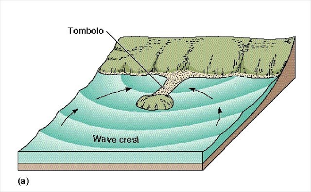
A true tombolo is formed by wave diffraction and refraction. Waves move toward the coastline and are slowed down as they enter the shallower water. They first reach the islands that are close to the shore. Because these waves are moving at a slower than normal pace, they move around the island instead of over it. As the water moves more slowly around the island, it picks up sediment along the way. When the waves meet on the other side of the island (the side facing the coast), the sediment is deposited. This sediment continues to build up until it creates the sandbar that connects the island to the beach. Once a Tombolo is formed, the island is then known as a tied island.
Evidence of the sand spit's gravel beach can still be found here. It forms part of the walking track around the wetlands and extends all the way to Coopernook. The beach would have been created some 125.000 years ago during a warm phase of the last Ice Age when the sea levels were higher. At that time the Cattai Wetlands would have formed part of the coastline with the ocean to the south east over the low lying land.
About 1.500 years ago sea levels fell to their present levels creating the Manning River floodplain we know today.
Sources:
Greater Taree City Council information
https://www.worldatlas.com/articles/coastal-landforms-what-is-a-tombolo.html
http://www.usi.edu/science/geology/jdurbin/geomorph/Coastal/part%202/Index_12.html
http://www.midcoast.nsw.gov.au/files/assets/public/document-resources/facilities-docs/manning/cattai-wetlands-walk-brochurev4.pdf
To claim this earthcache as "found", please send an email to the CO with your answers to the following questions and log your find. If there are any problems with your answers we will contact you.
1.) Describe with your own words how a Tombolo is formed.
2.) Which example of a present day Tombolo is mentioned at the information display and how far is it from Cattai Wetlands?
3.) Once a tombolo has formed, the island is no longer an independent land mass. What is the island called now?
4.) Optional (but highly appreciated) – attach photos of yourself taken on your visit to Cattai Wetlands.