Koh Mae Koh Headlands and Bays
Bays and headlands are often found at the same location. Bays are surrounded on three sides by land and can occur in either salt or fresh water. A headland is surrounded on three sides by water. Bays normally have sandy beaches. A headland usually has high rocky cliffs. A bay will have less wind and wave action than a headland. Headlands usually have big crashing waves and a lot of erosion.
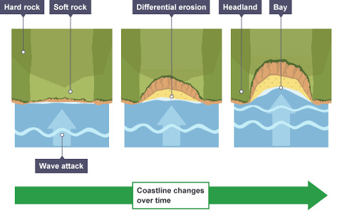
Figure 1 headland+and+bay+formation+diagram
The less resistant rock such as clay and sand is eroded and forms the bay. The more resistant rock such as granite, limestone and chalk remain. These harder more resistant rocks form the headland. The waves are concentrated on the headland so that caves, arches and stacks form. As the waves concentrate energy on the headlands; they dissipate energy on the bay making it calmer.
In this location, note the headlands where the waves have eroded and undercut the rock making it retreat inland. This is an early stage of headland erosion. It will cause stress on the cliffs and make the erosion progress faster. The debris from the undercut will move by longshore drift to the bay to increase material there. As the erosion progresses caves will form and eventually erode further to make an arch. The next stage is a stack and eventually that will erode too.
To log this Earth cache please e-mail me the answers through my geocaching.com account. Once you've sent the email with your answers, go ahead and log your find without waiting for a reply from me. I will contact you if there are any problems with your log entry. Please do not give away any answers in your log or your photos!
1. At the posted coordinates, look to the headland. At what stage in the erosion process is the headland? Why?
2. What difference do you note in the waves at the bay and at the headland?
3. If the rate of erosion of the headland is 20 mm per year, how many years do you estimate it has taken for this erosion to get to this depth? Explain how you got this answer.
References:
1. https://www.google.co.th/search?q=headland+and+bay+formation+diagram&oq=head&aqs=chrome.0.69i59l3j69i57j69i60.6254j0j4&client=ms-android-rogers-ca&sourceid=chrome-mobile&ie=UTF-8#imgrc=KlGvNnYb1Jwm4M
2. Wikipedia
อ่าวและอ่าวเกาะแม่ฮ่องสอน
บริเวณอ่าวและแหลมมักพบในที่เดียวกัน อ่าวล้อมรอบสามด้านโดยทางบกและสามารถเกิดขึ้นได้ทั้งในน้ำเกลือหรือเกลือ แหลมล้อมรอบสามด้านด้วยน้ำ อ่าวปกติมีหาดทราย แหลมมักจะมีหน้าผาหินสูง อ่าวจะมีลมและคลื่นน้อยกว่าแหลม ปลาวาฬมักมีคลื่นกระแทกขนาดใหญ่และการกัดเซาะมาก
X̀āw læa x̀āw keāa mæ̀ḥ̀xngs̄xn
briweṇ x̀āw læa h̄ælm mạk phb nı thī̀ deīywkạn x̀āw l̂xm rxb s̄ām d̂ān doy thāng bk læa s̄āmārt̄h keid k̄hụ̂n dị̂ thậng nı n̂ảkelụ̄x h̄rụ̄x kelụ̄x h̄ælm l̂xm rxb s̄ām d̂ān d̂wy n̂ả x̀āw pkti mī h̄ād thrāy h̄ælm mạk ca mīh̄n̂ā p̄hā h̄in s̄ūng x̀āw ca mī lm læa khlụ̄̀n n̂xy kẁā h̄ælm plāwāḷ mạk mī khlụ̄̀n krathæk k̄hnād h̄ıỵ̀ læa kār kạd seāa māk
รูปที่ 1 แผนผัง + แหลม + + + ช่อง + +
หินต้านทานน้อยเช่นดินเหนียวและทรายถูกกัดกร่อนและก่อตัวเป็นอ่าว หินที่ทนทานมากขึ้นเช่นหินแกรนิตหินปูนและชอล์กยังคงอยู่ โขดหินที่ต้านทานได้ยากกว่านี้เป็นแหลม คลื่นจะกระจุกตัวอยู่ที่หัวแหลมเพื่อให้มีถ้ำซุ้มและรูปทรงกอง ขณะที่คลื่นมุ่งพลังงานบนแหลม พวกเขากระจายพลังงานในอ่าวทำให้สงบ
ในตำแหน่งนี้ให้จดแหลมที่คลื่นที่กัดกร่อนและตัดหินทำให้หลบหนีเข้าฝั่ง นี่เป็นช่วงเริ่มต้นของการพังทลายของแหลม จะทำให้เกิดความเครียดบนหน้าผาและทำให้การกัดเซาะเร็วขึ้น เศษจากการตัดราคาจะเคลื่อนที่โดยการลอยล่องลอยไปยังอ่าวเพื่อเพิ่มวัสดุที่นั่น ขณะที่การกัดเซาะจะก่อให้เกิดถ้ำและกัดเซาะต่อไปเพื่อสร้างโค้ง ขั้นตอนต่อไปคือกองซ้อนและในที่สุดก็จะกัดเซาะด้วย
หากต้องการบันทึกแคช Earth โปรดส่งอีเมลคำตอบผ่านทางบัญชี geocaching.com ของฉัน เมื่อคุณส่งอีเมลพร้อมคำตอบแล้วให้ดำเนินการต่อและเข้าสู่ระบบค้นหาโดยไม่ต้องรอคำตอบจากฉัน ฉันจะติดต่อคุณหากมีปัญหากับรายการบันทึกของคุณ โปรดอย่าให้คำตอบใด ๆ ในบันทึกหรือรูปภาพของคุณ!
1. ที่พิกัดที่โพสต์ให้มองไปที่แหลม ขั้นตอนในกระบวนการกัดกร่อนคือขั้นตอนใด? ทำไม?
2 คุณสังเกตเห็นความแตกต่างอะไรในคลื่นที่อ่าวและที่แหลม?
3. บนชายหาดมีป้ายบอกสถานะว่าสามารถใช้บัลลังก์ได้ มันพูดว่าอะไร?
Rūp thī̀ 1 p̄hænp̄hạng + h̄ælm + + + ch̀xng + +
h̄in t̂ānthān n̂xy chèn din h̄enīyw læa thrāy t̄hūk kạdkr̀xn læa k̀x tạw pĕn x̀āw h̄in thī̀ thnthān māk k̄hụ̂n chèn h̄in kærnit h̄inpūn læa chxl̒k yạng khng xyū̀ k̄hod h̄in thī̀ t̂ānthān dị̂ yāk kẁā nī̂ pĕn h̄ælm khlụ̄̀n ca kracuk tạw xyū̀ thī̀ h̄ạwh̄ælm pheụ̄̀x h̄ı̂ mī t̄ĥả sûm læa rūp thrng kxng k̄hṇa thī̀ khlụ̄̀n mùng phlạngngān bn h̄ælm phwk k̄heā kracāy phlạngngān nı x̀āw thảh̄ı̂ s̄ngb
nı tảh̄æǹng nī̂ h̄ı̂ cd h̄ælm thī̀ khlụ̄̀n thī̀ kạdkr̀xn læa tạd h̄in thảh̄ı̂ h̄lb h̄nī k̄hêā f̄ạ̀ng nī̀ pĕn ch̀wng reìm t̂n k̄hxng kār phạng thlāy k̄hxng h̄ælm ca thảh̄ı̂ keid khwāmkherīyd bn h̄n̂āp̄hā læa thảh̄ı̂ kār kạd seāa rĕw k̄hụ̂n ṣ̄es̄ʹ cāk kār tạdrākhā ca khelụ̄̀xnthī̀ doy kār lxy l̀xng lxy pị yạng x̀āw pheụ̄̀x pheìm wạs̄du thī̀ nạ̀n k̄hṇa thī̀ kār kạd seāa ca k̀x h̄ı̂ keid t̄ĥả læa kạd seāa t̀x pị pheụ̄̀x s̄r̂āng không k̄hận txn t̀x pị khụ̄x kxng ŝxn læa nı thī̀s̄ud k̆ ca kạd seāa d̂wy
h̄āk t̂xngkār bạnthụk khæch Earth pord s̄̀ng xīmel khả txb p̄h̀ān thāng bạỵchī geocaching.Com k̄hxng c̄hạn meụ̄̀x khuṇ s̄̀ng xīmel phr̂xm khả txb læ̂w h̄ı̂ dảnein kār t̀x læa k̄hêā s̄ū̀ rabb kĥnh̄ā doy mị̀ t̂xng rx khả txb cāk c̄hạn c̄hạn ca tidt̀x khuṇ h̄āk mī pạỵh̄ā kạb rāykār bạnthụk k̄hxng khuṇ pord xỳā h̄ı̂ khả txb dı «nı bạnthụk h̄rụ̄x rūpp̣hāph k̄hxng khuṇ!
1. Thī̀ phikạd thī̀ phos̄t̒ h̄ı̂ mxng pị thī̀ h̄ælm k̄hận txn nı krabwnkār kạdkr̀xn khụ̄x k̄hận txn dı? Thảmị?
2 Khuṇ s̄ạngket h̄ĕn khwām tæk t̀āng xarị nı khlụ̄̀n thī̀ x̀āw læa thī̀ h̄ælm?
3. ถ้าอัตราการพังทลายของแหลมเป็น 20 มม. ต่อปีคุณคาดว่าจะใช้เวลาหลายปีในการกัดกร่อนนี้เพื่อให้ได้ความลึกนี้หรือไม่? อธิบายว่าคุณมีคำตอบนี้อย่างไร T̄ĥā xạtrā kār phạng thlāy k̄hxng h̄ælm pĕn 20 mm. T̀x pī khuṇ khād ẁā ca chı̂ welā h̄lāy pī nı kār kạdkr̀xn nī̂ pheụ̄̀x h̄ı̂ dị̂ khwām lụk nī̂ h̄rụ̄x mị̀? Xṭhibāy ẁā khuṇ mī khả txb nī̂ xỳāngrị
References:
1. https://www.google.co.th/search?q=headland+and+bay+formation+diagram&oq=head&aqs=chrome.0.69i59l3j69i57j69i60.6254j0j4&client=ms-android-rogers-ca&sourceid=chrome-mobile&ie=UTF-8#imgrc=KlGvNnYb1Jwm4M
2. Wikipedia