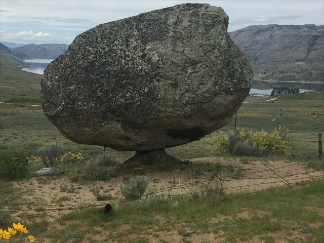
Omak Rock aka Balance Rock perches precariously on a hillside above Omak Lake. It is a massive 40-ton (36 metric tons) granite boulder that traveled to this spot all the way from Canada.
Boulders such as this that rest far away from their origin are called erratics. Generally they were transported within glaciers or inside icebergs during floods. Erratics are common in Washington state because during the ice age, most of the northern third of the state was under a massive sheet of ice called the Cordilleran Ice Sheet. Longer sections called lobes extended farther south from the main ice sheet; this valley was covered by the Okanogan Lobe.
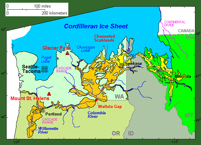
It was easy for the glacier to flow into this valley because it had already been carved by the Columbia River. Prior to the ice age, the Columbia River flowed through here. Eventually it was diverted by lava flows between the valley and the river's current channel to the south. Glaciers carved the riverbed deeper to reveal the valley you see today, and it's now the bed for Lake Omak.
There are plenty of erratic boulders along the valley and near Balance Rock. What makes this boulder unique is that it is perfectly balanced on a much smaller piece of native granite bedrock. Balance Rock is so stable that it survived a 7.5 Earthquake in 1872 without falling off! The epicenter of that earthquake was very close to Balance Rock, perhaps even directly under it. How did it come to be in that presentation and how could it possibly have been balanced there so precariously for thousands of years?
- It could have been dropped by the glacier and settled right on top of the granite bedrock where it remains balanced to this day.
- It could have been dropped by the glacier with the rest of the glacial till above the granite bedrock. As the finer elements in the surrounding till eroded away, the boulder sunk until it reached the bedrock and happened to settle on the bedrock in a way that it balanced. It remained balanced while the remaining till around it washed/eroded away, eventually exposing the entire boulder as well as the bedrock that supports it.
- Either way, the weight of the boulder pressing down on the piece of bedrock helped the bedrock resist eroding underneath. The size of the boulder also acts as a shelter for the base, reducing the erosion from rain and snow.
- The base will continue to erode and eventually drop the rock, but don't sit around and wait for it. Balance Rock has been here for approximately 10,000 years and will likely remain that way long after you depart this Earth.
|
As you examine the boulder and surrounding area to answer the logging tasks, remember that you are a guest on sovereign land owned by the Confederated Tribes of the Colville Reservation. Be respectful of their property and this special balanced rock.
|
Logging Tasks
Send your answers to me from the message center or by email through my profile. The message center is preferred. Do Not post the answers in your log.
1. Examine the structure of the boulder. You can easily see it in exposed sections of the boulder where the lichen-covered exterior has flaked off. Describe the size and color of the crystals in the groundmass (main structure). Is this groundmass homogeneous? If not, what else do you see in it?
2. Carefully examine the structure of the pedestal the boulder rests on. Describe the colors of the crystals. Is it homogeneous or are there inclusions in it? Describe the size and color of the crystals. Does the pedestal match the boulder that sits on it? If not, describe the differences.
3. Look carefully at the contact points between the pedestal and the boulder. Is there full contact between the pedestal and the boulder? If not, how many primary contact points do you see? To count the contact points, circle around and look at it from different directions and see where light comes through. Do you think the number of contact points contribute to the stability or do they make it less stable?
4. Explore the nearby erratics and find the one very close to balance rock which looks like this:
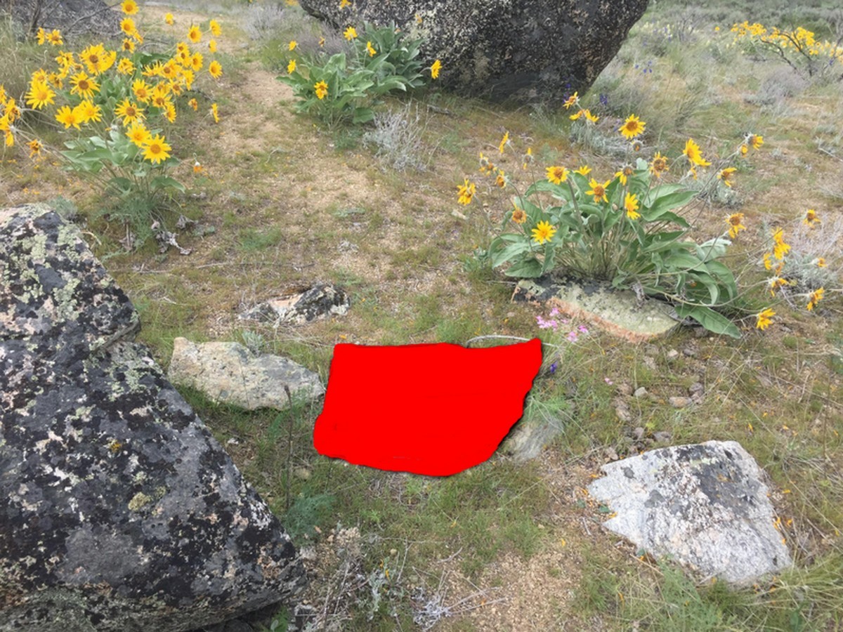
If you didn't print a photo or have the image on your geocaching app, it is among the closest boulders south of Balance Rock, measures about 12"x18" and looks like Washington State in reverse without Puget Sound. Does the crystal structure match the boulder, or the pedestal, or neither? What can you surmise from that?
5. Based on the topography, did this boulder roll downhill to its current spot or was it carried uphill to this location?
6. Look at the grus that covers the pedestal and landscape. What do these materials look like and do they match the boulder, pedestal or something else? Is it all the same color from the pedestal and outward beyond the erratic, or does it change? Describe what you see and tell me why you think it might be that way.
I invite you to take a photo of yourself with balance rock and post it with your log. This is an optional task.
Send your answers to me from the message center or by email through my profile. The message center is preferred. Do Not post the answers in your log.
This EarthCache was placed with permission from Cody Desautel, the Natural Resource Director of the Colville Tribes.
This is the EarthCache that was under development and mentioned in Geocaching's podcast about EarthCaches in April 2018.