Le Lac de Pont
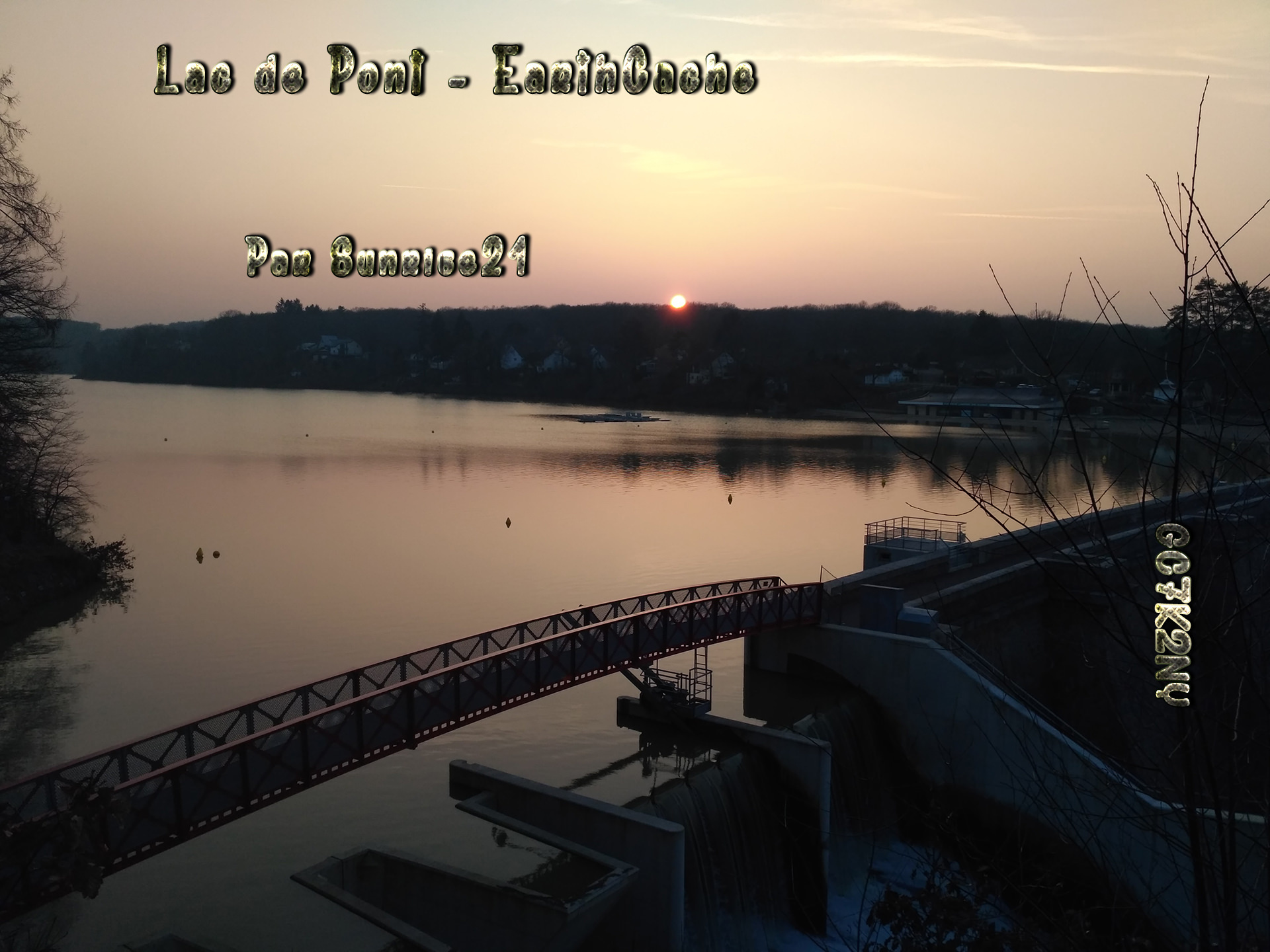
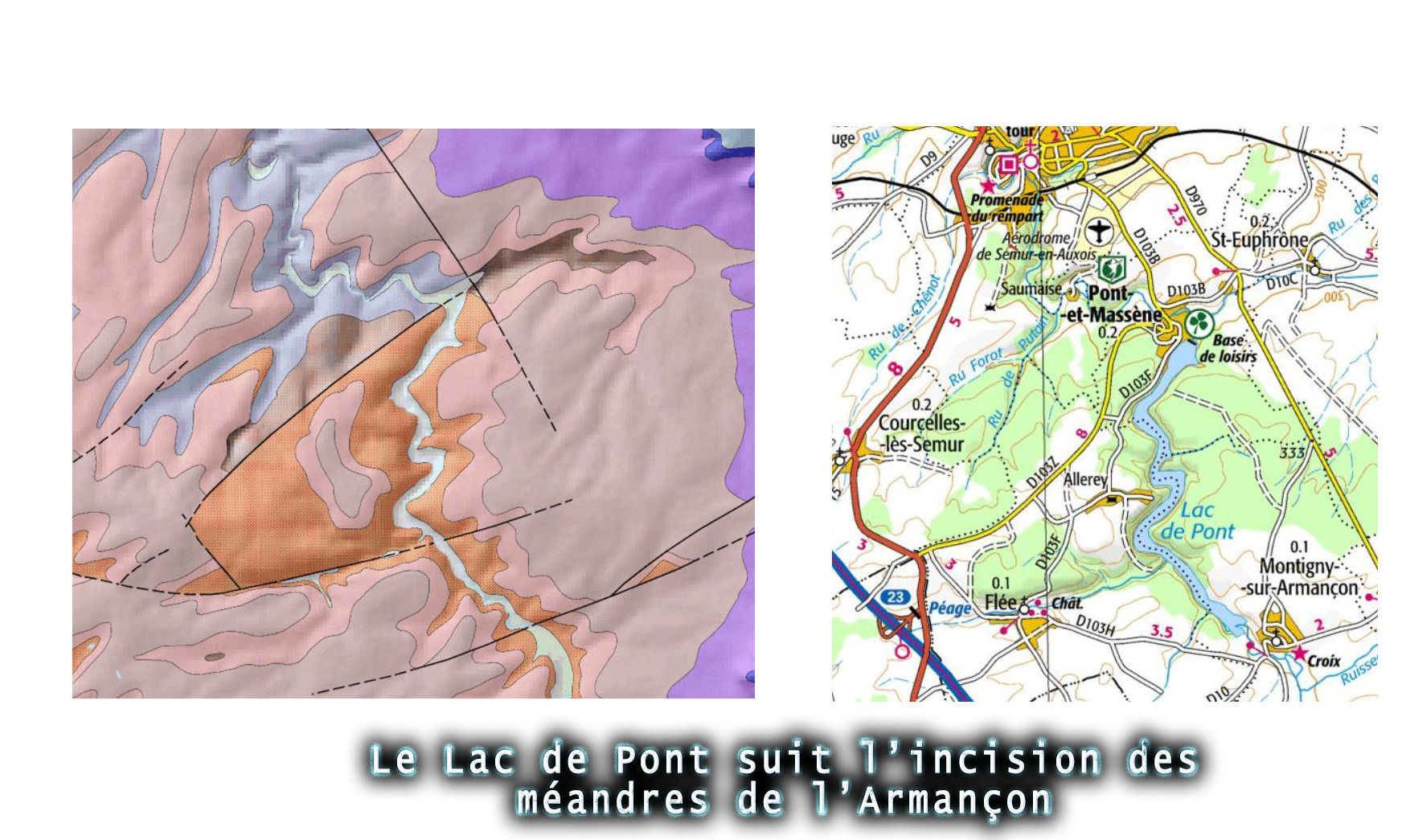
FR Situé sur Pont et Massène, le Lac de Pont est une superbe retenue d’eau datée de 1883, d’environ 3 millions de m3, sur une longueur d’environ 5 Kms en suivant la forme des méandres initiaux d’incision jusqu’à Montigny-sur-Armançon.
Bien que situé dans l’Auxois il est souvent référencé dans les Grands Lacs du Morvan, dans la mesure où il est situé sur la rivière morvandelle l’Armançon. A cet égard, il est possible de constater de manière notoire que les eaux de l’Armançon au niveau du barrage sont brunâtres, en raison des produits humiques issus directement du Morvan où l’Armançon prend sa source. Enfin, autre originalité toujours en rapport avec son origine géologique, les sols sont naturellement contaminés par l'Arsenic (mais de manière acceptable !).
Le Lac de Pont profite justement de l’encaissement de l’Armançon dans le socle cristallin du Morvan pour se constituer des réserves d’eau ; autrefois utilisées uniquement pour alimenter le canal de Bourgogne, elles servent aussi aujourd'hui à alimenter en eaux potables une soixantaines de communes avoisinantes. De plus il s’est découvert une nouvelle fonction en tant que base de loisirs.
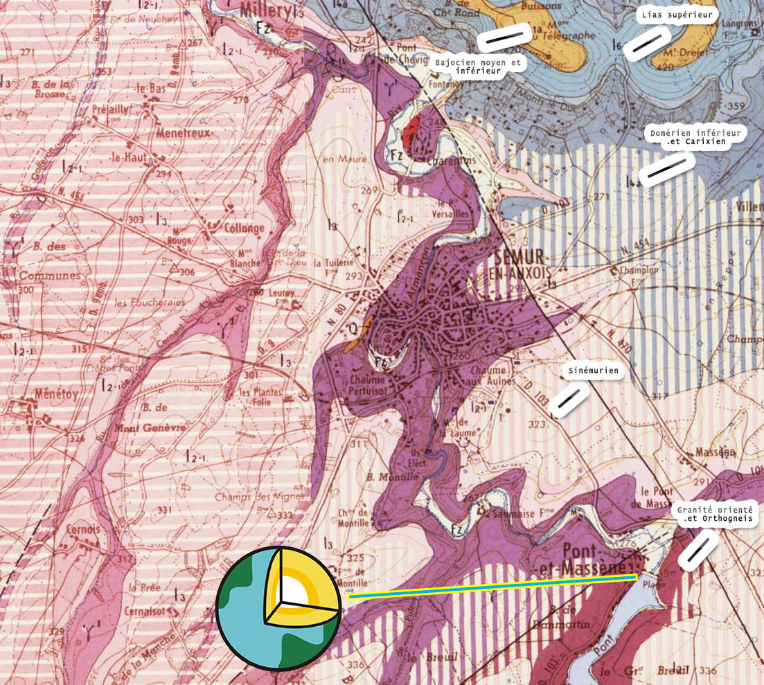
En outre, le Lac est installé au contact naturel de différentes roches : les granites de Semur et les roches métamorphiques de l’Avallonnais.
Merci à AtraN21 pour la relecture
The Lake "of Pont"
EN
Located on Pont and Massene, the Lac de Pont is a superb reservoir of water dating from 1883, about 3 million m3, over a length of about 5 Kms following the shape of the initial meandering incisions up to Montigny-sur-Armançon.
Although located in Auxois it is often referenced in the Great Lakes of Morvan, insofar as it is located on the river Morvan Armançon. In this respect, it is noticeable that the Armançon waters at the dam are brownish because of the humic products directly from the Morvan where the Armançon originates. Finally, another originality always related to its geological origin, soils are naturally contaminated by Arsenic (but in an acceptable way!).
The Lac de Pont benefits precisely from the cashing of the Armançon in the crystalline basement of the Morvan to build water reserves; formerly used only to supply the Burgundy Canal, they are also used today to supply drinking water to sixties neighboring towns. In addition he discovered a new function as a leisure base.
In addition, the lake is installed in natural contact with different rocks: the Semur granites and the metamorphic rocks of the Avallonnais.
Thanks to AtraN21 for proofreading
Rappel concernant les « Earthcaches »: Il n'y a pas de conteneur à rechercher ni de logbook à renseigner. Il suffit de se rendre sur les lieux et d'éxécuter les requêtes du geocacheur.
Loguez cette cache "Found it" et envoyez-moi vos propositions de réponses soit via mon profil, soit via la messagerie geocaching.com (Message Center), EN PRECISANT LE NOM ET CODE GC DE LA CACHE et je vous contacterai en cas de problème.
Il est aussi apprécié d'avoir des photos des géocacheurs sur les lieux de l''EarthCache. Sentez vous inspiré de poster des photos de vous lors de cette visite ( optionnelle mais sympathique)
---
Reminder concerning "Earthcaches": there is neither a container to look for nor a logbook to sign.
Log in this cache " Found it " and send me your answers proposals or via my profile or via geocaching.com messaging (Message Center ) , BY PROVIDING THE NAME AND GC CODE OF THE CACHE and I will contact you in case of problems .
We also enjoy seeing photographs of people visiting this EarthCache. Please feel free to log photos of your visit...(this is entirely optional but funny)
Grace à la lecture attentive du descriptif et de ses schemas, grâce à votre observation, répondez aux questions suivantes :
Thanks to the reading with attentin of the description and the draw, thanks your observation, answer the following questions:
FR
WP1 Depuis le haut de la digue,
Q1- Observer la Vallée de l’Armancon . Pourquoi selon vous était-elle un emplacement propice à la création du Lac ?
Q2- A quel niveau est placée la Vallée par rapport à la table Sinémurienne ?
Q3 - Quel autre element geologique est il possible d’apercevoir en dernier plan ?
WP2 Depuis la betonnière d’époque,
Q4- En combien de cascade l’eau s’ecoule t elle depuis le barrage ?
Q5- Comment est encastré le barrage ?
Q6- a/Est-ce le même materiau pour les fondations ?b/Pourquoi ce choix selon vous ?
Q7 Facultatif, une photo depuis chaque WP, mais sans donner d elements de reponse svp !
EN
WP1 From the hight of dike,
Q1- Look at the Vallée de l'Armancon. Why do you think it was a favorable location for the creation of the lake?
Q2- At what level is the Valley placed in relation to the Sinemurian table?
Q3 - What other geological element is it possible to see in the background?
WP2 From the concrete mixer old-aged
Q4- How much water does the water run from the dam?
Q5- How is the dam embedded?
Q6- a / Is this the same material for foundations?
b / Why this choice according to you?
Q7 Optional, a photo from each WP, but without giving any answers please!
JOYEUX & HAPPY EARTHCACHING !