The stark, rocky causeway arcing across the Avon River at Windsor, Nova Scotia, has been a source of concern to many environmentalists ever since the first boulders tumbled into the roiling tidal waters almost 40 years ago. Many ecological changes, ranging from accumulation of sediments along stretches of the riverbed to decimation of fish stocks, have been attributed to the blockage of tidal flow by this barrage.
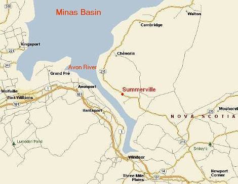
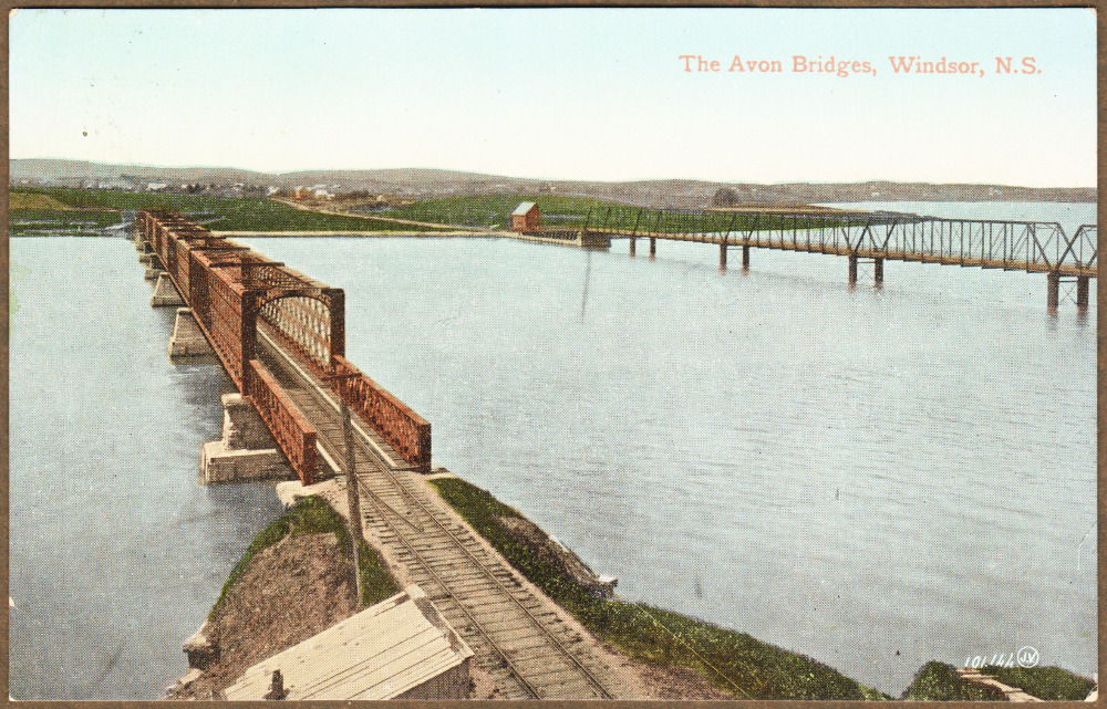
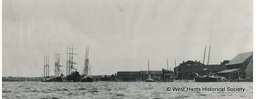
The Avon River is a small river in Windsor, Nova Scotia Canada. A northerly flowing river, the its flow rises at an elevation of 145 metres (475 ft.) at Card and Bag Lakes on the South Mountain, a distance of approximately 29 kilometres (18 miles) southwest of the town of Windsor. Shipbuilding was a prominent industry between 1840 and 1890 when it flourished. However, in the 1870's the industry began to slow as steamers became more prominent.
Causeway Construction .
Construction of the causeway across the Avon River at Windsor began in the fall of 1968, with the dumping of rock fill occurring from both sides of the river. By January 1970, only a narrow gap remained. Twice the incoming tides washed out the human efforts to close the gap. A control structure with two large gates was installed and the remaining gap closed in the summer of 1970. The roadway was opened for traffic later that autumn. It required 1.65 million tonnes of rock fill the 700 metres (2,300 feet) long causeway. The gates controlling the water flow have made it so the endangered salmon cannot enter the Avon River to spawn like then did in the past.
In addition to protecting more than 1,400 hectares (3,500 acres) of farmland and providing an important highway and railway link, the new causeway effectively halted the periodic flooding of parts of downtown Windsor and adjacent farmlands. This would happened occasionally from the world’s highest tides. It offered more than a metre higher protection against tidal flooding than most other dykes in the Fundy region, thus providing a substantial buffer against any future rise in sea level.
Turning the Tides
To manage the flow of water up and downstream, the control structure, 79 metres (260 feet) in length, was built into the causeway near its western end in the main channel of the river. It consists of two large culverts, each 6 metres (20 feet) wide and 4.5 metres (15 feet) high, made of reinforced concrete and solidly anchored on pilings. The raising and lowering of two 13-tonne structural-steel sluice gates regulates the passage of water through these culverts. The gates are opened on the falling tide when it is low enough to allow any excess freshwater that has accumulated in the lake to drain out. Sometimes the water level in the lake is purposely allowed to fall well below normal levels. If excessive precipitation, snowmelt and runoff are expected, then the gates are opened higher to allow more water than normal to drain out. Lowering the lake in this way gives it the capacity to receive more runoff later without backing up and causing flooding upstream. The excess water can then be released once the tide has dropped below the level of the lake.
Geological changes from the causeway
 Shifting Sediments
Up stream:
Over the four decades since construction of the causeway, many changes observed in the river. Perhaps the most prominent of these changes involve the shifting sediments. The causeway largely halted the daily and seasonal large-scale movements of suspended sediments up and down the river. Upriver, mudflats and shoals were starved of fresh sediments and steadily diminished in size. Along the riverbanks, salt marshes were also deprived of both sediments and seawater and thus gradually shrank, some disappearing and others transforming into freshwater marshes. It is estimated that about 87 hectares (216 acres) of upstream salt marsh were lost in this manner.
Downstream:
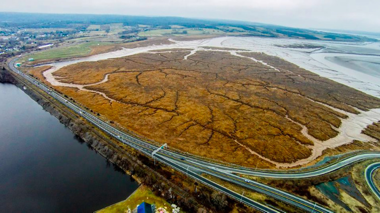
The construction of the causeway has dramatically affected the Avon River downstream from Windsor, with large parts of the once-navigable river now being obstructed by large mud flats and vegetation, owing to the lack of tidal exchange and freshwater discharge. There has been a steady build up of massive quantities of fine sediment on a pre-existing intertidal mud bar. As soon as the causeway was completed, sediment began accumulating by as much as 15 cm (6 inches) a month during the summer. For two decades the expanding mudflats remained soupy, unstable and mostly barren of visible life. However, by the early 1990's the accumulating mud had consolidated and stabilized sufficiently to support growing populations of burrowing invertebrates and the first pioneering shoots of the salt marsh grass Spartina alterniflora. These hardy, well-rooted plants securely anchored the mud and, by acting like swaths of miniature snow fencing, further hastened the deposition of swirling silt. It was originally anticipated that the mud would build right up against the downstream face of the causeway; instead, however, a broad channel persisted along the front of causeway because of the tidal flows. However, by the late 1990's this channel too had begun to close, so that the saltmarsh may eventually come to rest against the causeway as originally predicted.
Positive outcomes from the Causeway
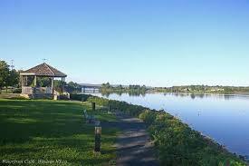
The man made Pesaquid Lake provides Windsor with an attractive waterfront skirting a broad expanse of placid water, a far cry from the acres of seemingly barren mudflats and churning, muddy waters that once formed the downtown vista.
A pleasant walkway, featuring colourful and informative signs about the history of the town, now skirts the downtown waterfront. This scenic pathway extends upriver, crosses the old road bridge, runs back down the Falmouth side of the river and returns across the causeway to the starting point, providing residents and visitors with a loop trail on which to stretch muscles, walk their dogs or perhaps even geocache. The lake also provides other recreational opportunities, including a paddling club, complete with a boathouse and floating docks to handle the canoes and kayaks used in the recreational and competitive paddling programs. It is perhaps noteworthy that several Canada Games gold medal winners in canoeing and kayaking, as well as a number of national champions, have trained there.
Another popular recreational activity in the area that depends on the presence of the large freshwater lake is skiing. Ski Martock operates seven runs on nearby 185 metre (600 feet) high Martock Mountain and routinely pumps freshwater from the lake to feed its snowmaking machines. These machines can draw over 8 thousand litres (>1,800 gallons) of water per minute and blow out nine tonnes of fresh snow every minute onto the ski runs. This amounts to over 120 million litres (26 million gallons) of water and almost 14 thousand tonnes of snow each day.
To log: You can likely see what you need by just driving across the causeway in Windsor and looking towards the Earthcache area to answer questions. There are parking coordinates to park at and view the area. This is as close as you will be able to get. The icon is just a location to look towards. Do not attempt to walk to the coordinates.
1. Let me know at what tide stage you visited this Earthcache and what you saw of the silt and sediment downstream.
2. Why do you think the salt water marsh receded upstream after the causeway was built?
3. Do you think Pesaquid Lake will flood Windsor again? And why?
4. How did the silt get deposited downstream?
5. Do you think the sediment will continue to expand to lie totally against the causeway? {Right now a broad channel of tidal water still is here because of the tidal flows). Note any reasons why you think.
.
6. [REQUIRED] In accordance with the updated guidelines from Geocaching Headquarters published in June 2019, photos are now an acceptable logging requirement and WILL BE REQUIRED TO LOG THIS CACHE. Please provide a photo of yourself or a personal item here to prove you visited the site..