|
น้ำพุร้อนและร้อน
น้ำพุร้อนและยังมีน้ำพุเดือด (ชกีย์) ทำงานเป็นระยะๆจนกว่าน้ำเป็นระยะๆที่มีความดันสูงบางส่วนเช่นน้ำพุ
บางสปริงผ่านไปเพียงไม่กี่นาทีในขณะที่คนอื่นอาจใช้เวลาหลายชั่วโมงถึงเดือนระหว่างปะทุ ใช้กับความสูงของคอลัมน์น้ำที่ดีดออกไป จากไม่กี่นิ้วไปกว่าร้อยเมตรสามารถเข้าถึงได้ทั้งนี้ขึ้นอยู่กับแหล่งที่มา แต่มีน้ำพุร้อนที่ไม่เพียงแต่บนพื้นผิวของโลกแต่พวกเขายังพบบนพื้นทะเล อุณหภูมิสูงสุดวัดได้ถึงวันที่ฤดูใบไม้ผลิใต้น้ำคือ๔๐๗.๒องศาเซลเซียส ไม่สามารถวัดอุณหภูมิดังกล่าวที่สปริงบนพื้นผิวของโลก
เนื่องจากกระบวนการในการตกแต่งภายในของโลกน้ำที่มีความร้อนที่อุณหภูมิระหว่าง๑๐๐และ๒๕๐องศาเซลเซียส ๔๐ถึง๑๐๐องศาเซลเซียสในทางกลับกันอุณหภูมิของน้ำที่เป็นเพียงทันทีที่มันออก
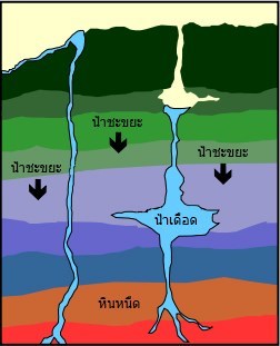
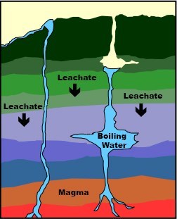
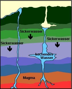
มีชกีย์และน้ำพุร้อนในบริเวณภูเขาไฟที่ใช้งานอยู่ ช่องในรูปแบบของท่อที่เข้าถึงลึกเข้าไปในชั้นหินและสิ้นสุดในอ่างเก็บน้ำใต้ดิน เหล่านี้จะเต็มไปด้วยน้ำบาดาล.
ช่องทางการปะทุเป็นน้ำบาดาลที่ได้รับการรั่วไหล คอลัมน์น้ำที่อยู่เหนือน้ำร้อนทำให้น้ำที่จะเริ่มเดือดเท่านั้นที่อุณหภูมิสูง น้ำร้อนโดยหินภูเขาไฟจะถูกกดขึ้นโดยความดันที่เกิดขึ้นเป็นไอน้ำ ในกระบวนการนี้แร่ธาตุที่ละลายและอนุภาคหินจะถูกดำเนินการ
หากเปิดช่องว่างจะแน่นน้ำอุ่นออกมาเหมือนยิงน้ำพุ ด้วยช่องเปิดที่กว้างขึ้นไอน้ำสามารถรั่วไหลได้อย่างอิสระ เหล่านี้เรียกว่าแหล่งไอน้ำ สำหรับน้ำพุร้อนไอน้ำจะระบายความร้อนได้เพียงพอและแบบย่อ |
|
 |
ปริมาณของน้ำที่สามารถเข้าถึงได้ขึ้นอยู่กับปัจจัยหลายอย่าง ซึ่งรวมถึงความยาวและความกว้างของช่องการปะทุที่มีคอขวด อุณหภูมิของหอพักหรือหินภูเขาไฟและทำให้อุณหภูมิที่น้ำร้อน
การผสมผสานพิเศษของสภาพทางธรณีวิทยาและภูมิอากาศเป็นสิ่งจำเป็นสำหรับน้ำพุร้อนหรือชกีย์ที่จะโผล่ออกมา น้ำประปาแหล่งความร้อนและต่ำสุดหอลึกในหินซึ่งทำหน้าที่เป็นอ่างเก็บน้ำเป็นเงื่อนไขที่ขึ้นอยู่
|
|
คนที่มาที่สถานที่นี้เป็นหลักใช้ผลการรักษาของน้ำอุ่นน้อย. นอกเหนือจากอนุภาคหินและตะกอนแร่ธาตุที่แตกต่างกันจะถูกถ่ายทอดไปยังพื้นผิว บ่อยครั้งที่โคมในสีที่แตกต่างกันสามารถมองเห็นได้ที่จุดเต้าเสียบของแหล่งที่มา
ขึ้นอยู่กับแผนที่ของน้ำพุร้อนที่รู้จักกันดีในภูมิภาคของเชียงใหม่เชียงรายและพระอาทิตย์หลวงก็สามารถเห็นได้ว่าในพื้นที่เหล่านี้ในชั้นลึกของพื้นผิวที่มีกิจกรรมภูเขาไฟที่ทำให้เกิดการชกีย์และน้ำพุร้อนส่งเสริม ในประเทศอื่นๆมีน้ำเย็นชกีย์ที่ระเบิดจะถูกเรียกโดยคาร์บอนไดออกไซด์ออก มือมนุษย์ที่สร้างเทียมในพื้นที่ใต้พิภพเป็นไปได้
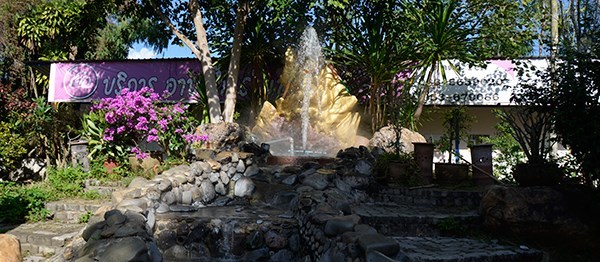
ที่แม่ Khachan สปริงส์และชกีย์น้ำพุน้ำไม่ยิงบวับลงในอากาศ ในหลายสถานที่ที่มีอยู่แล้วระบายความร้อนไอน้ำมาถึงพื้นผิว, สำหรับบาง, มีบาร์ข้างต้นโกหกการระบาดเป็นเบรก. อย่างต่อเนื่อง bubbling และน้ำพุน้ำขนาดเล็กบางครั้งสามารถมองเห็นได้ในบริเวณใกล้เคียง ฤดูใบไม้ผลิธรรมชาติได้รับการเติมเต็มที่นี่, การสร้างสระและ wells กระจายอยู่ในพื้นที่กว้าง ในพื้นที่ด้านหลังจะมีการสร้างกระแสข้อมูลอีกต่อไปในแนวทางของแหล่งที่มา
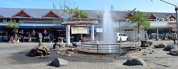
ชาวบ้านใช้แหล่งธรรมชาติของความร้อนสำหรับไข่เดือดที่จะขายพวกเขาที่จะผ่านนักท่องเที่ยว ในหลายสถานที่คนนั่งและมีขาของพวกเขาในไม่มีน้ำร้อนเพื่อให้อีกต่อไป
หากต้องการเข้าสู่ระบบ แคชแผ่นดิน นี้ให้ตอบคำถามในภายหลัง
- แร่ธาตุที่สกัดด้วยน้ำร้อนขึ้นไปและถูกเก็บไว้รอบๆชกีย์และน้ำพุร้อน? -(โทรอย่างน้อย 3)
- โคมสีถูกผลิตจากจุดออกอย่างไร?
- วิธีสูงคืออุณหภูมิใน° c ที่ WP, ว่าสูงสามารถอุณหภูมิเมื่อมีการรั่วไหล?
– ขึ้นอยู่กับหนึ่งในชื่อ-/เครื่องหมายข้อมูล
- ไม่บังคับ: หากต้องการบันทึกรูปภาพของคุณอุปกรณ์นำทางหรือมิ่งขวัญในพื้นที่
เขียนรายการบันทึกของคุณและส่งจดหมายไปให้ฉัน แคชแผ่นดิน-ตอบ กับคำตอบของคุณ สิ่งที่ไม่ควรถูกต้อง, ผมจะติดต่อคุณ.
ข้อความเกี่ยวกับศูนย์ข้อความ (แชท) จะไม่อ่าน/สังเกตโดยฉัน.
|
|
Hot Spring and Geyser
Hot springs and also boiling springs (geysers) run intermittently until periodically water, with partial high pressure, like fountains.
Some springs pass only a few minutes, while others may take several hours to months between eruptions. The same applies to the height of the ejected water column. From a few inches to over a hundred meters can be reached depending on the source. But there are hot springs not only on the surface of the Earth, but they are also found on the sea floor. The highest temperature measured to date at an underwater spring is 407.2 degrees Celsius. Such temperatures cannot be measured at the springs on the Earth's surface.
Due to the processes in the Earth's interior, the water is heated to temperatures between 100 and 250 °c. 40 to 100 °c, on the other hand, the temperature of the water is only as soon as it exits.
There are geysers and hot springs in active volcanic areas. Channels in the form of tubes that reach deep into the magma layers and end in underground water reservoirs. These are filled by groundwater.
The eruption channel is the ground water that has been leaked. The water column above the warming water causes the water to start boiling only at a higher temperature. Water heated by hot volcanic rock is pressed upward by the resulting pressure as water vapor. In this process, dissolved minerals and rock particles are carried.
If the opening, the gap is tight, the heated water comes out like a fountain shot. With wider openings, the water vapor can leak freely. These are called steam sources. For hot springs, the steam is sufficiently cooled and condensed. |
|
 |
The amount of water that can be reached depends on several factors. This includes the length and width of the eruption channel with bottlenecks. The temperature of the magma chamber, or the volcanic rock, and thus the temperature at which the water is heated.
A special combination of geological and climatic conditions is required for hot springs or geysers to emerge. A water supply, heat source and minimum a chamber deep in the rock, which serves as a water reservoir, are dependent conditions.
|
|
People who come to this place primarily use the therapeutic effect of the ascending, warm water. In addition to the rock and sediment particles, different minerals are also conveyed to the surface. Often a luminaire in different colours can be seen at the outlet point of sources.
Based on the map of the well-known hot springs in the regions of Chiang Mai, Chiang Rai and Mea Hong Sun, it can be seen that in these areas, in deeper layers of the surface, there are volcanic activities that make the emergence of geysers and hot springs Promotes. In other countries, there are cold water geysers where the eruption is triggered by released carbon dioxide. Human hands, artificially created in geothermal area, are also possible.
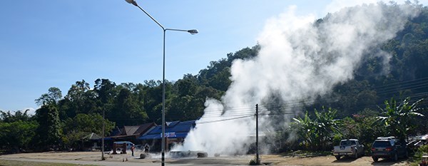
At Mae Khachan Springs and geysers, the water fountain does not shoot spectacularly into the air. In several places already cooled water vapor comes to the surface, for some, with above-lying bars an outbreak is braked. Constantly bubbling springs and occasionally smaller water fountains can be seen in the vicinity. The natural spring has been fortified here, creating pools and wells spread over a wide area. In the rear area, a longer stream was created at the source's approach.
The locals use the natural source of heat for boiling eggs to sell them to passing tourists. In several places people sit and have their legs in the no longer so hot water.
To log this Earthcache, answer me subsequent questions
- Which minerals are extracted with the hot water upwards and are stored around geysers and hot springs? -(call at least three).
- How is the coloured luminaire produced at the exit point?
- How high is the temperature in °c at WP, how high can the temperature be when it is leaking?
– stands on one of the name-/information sign.
- Optional: To log a picture of you, your GPS or mascot in the area.
Writes Your log entry and send me a mail to earthcache-answer with Your answers. Should something not be right, I will contact You.
Messages about the Message Center (chat) are not read / noticed by me.
|
|
Heiße Quelle und Geysir
Heiße Quellen und auch Springquellen (Geysir) stoßen unregelmäßig bis periodisch Wasser, mit teilweise hohem Druck, fontänenartig aus.
Bei einigen Quellen vergehen nur wenige Minuten, bei anderen können mehrere Stunden bis Monate zwischen den Eruptionen vergehen. Ebenso verhält es sich mit der Höhe der ausgestoßenen Wassersäule. Von ein paar Zentimeter bis zu über hundert Meter können je nach Quelle erreicht werden. Aber nicht nur auf der Erdoberfläche gibt es heiße Quellen, auf dem Meeresgrund sind sie ebenfalls zu finden. Die höchste bis jetzt gemessene Temperatur an einer Unterwasserquelle beträgt 407,2 Grad Celsius. Solche Temperaturen wird man an den Quellen auf der Erdoberfläche nicht messen können.
Durch die Vorgänge im Erdinneren wird das Wasser auf Temperaturen zwischen 100 und 250°C erhitzt. 40 bis 100°C hingegen beträgt die Temperatur des Wassers nur noch sobald es austritt.
In aktiven vulkanischen Gebieten kommen Geysire und heiße Quelle vor. Kanäle in Form von Röhren, die tief bis in die Magmaschichten reichen und in unterirdischen Wasserreservoire enden. Gefüllt werden diese durch Grundwasservorkommen.
In dem Eruptionskanal steht das eingelaufene Grundwasser. Die über dem erwärmenden Wasser stehende Wassersäule bewirkt, dass das Wasser erst bei höherer Temperatur zu sieden beginnt. Dass durch heißes vulkanisches Gestein erhitzte Wasser wird durch den entstehenden Druck als Wasserdampf nach oben gepresst. Dabei werden gelöste Mineralien und Gesteinspartikel mitgeführt.
Ist die Öffnung, der Spalt eng, kommt das erhitzte Wasser fontänenartig hervorgeschossen. Bei breiteren Öffnungen kann der Wasserdampf ungehindert austreten. Diese werden als Dampfquellen bezeichnet. Bei heißen Quellen ist der Dampf genügend abkühlt und kondensiert. |
|
 |
Die Höhe, die das austretende Wasser erreichen kann, hängt von mehreren Faktoren ab. Dazu gehören die Länge und Breite des Eruptionskanals mit Engstellen. Die Temperatur der Magmakammer, bzw. des Vulkangesteins und dadurch die Temperatur, auf die das Wasser erhitzt wird.
Eine spezielle Kombination von geologischen und klimatischen Bedingungen ist erforderlich, damit heiße Quellen oder Geysire entstehen können. Eine Wasserversorgung, Wärmequelle und Minimum eine tief im Gestein liegende Kammer die als Wasserreservoir dient, sind abhängige Voraussetzungen.
|
|
Menschen die an diesen Ort kommen, nutzen vorrangig die therapeutische Wirkung des aufsteigenden, warmen Wasser. Neben den Gesteins- und Sedimentpartikel werden auch unterschiedliche Mineralien an die Oberfläche gefördert. Oftmals ist an der Austrittstelle von Quellen ein leuchten in verschiedenen Farben zu sehen.
Anhand der Karten-Darstellung der bekannten heißen Quellen in den Regionen Chiang Mai, Chiang Rai und Mea Hong Sun kann man darauf schließen, dass es in diesen Bereichen, in tieferen Erdschichten, vulkanische Aktivitäten gibt, die die Entstehung von Geysiren und heißen Quellen fördert. In anderen Ländern gibt esKaltwassergeysire bei denen die Eruption durch freigesetztes Kohlenstoffdioxid ausgelöst wird. Von Menschenhand, in Geothermalgebieten künstlich geschaffen, sind ebenfalls möglich.
Bei Quellen und Geysiren von Mae Khachan schießen die Wasserfontäne nicht spektakulär in die Luft. An mehreren Stellen tritt hier bereits herabgekühlter Wasserdampf an die Oberfläche, bei einigen wird mit darüber liegenden Balken ein Ausbruch gebremst. Ständig sprudelnde Quellen und vereinzelt kleinere Wasserfontänen sind im Umkreis zu beobachten. Die natürlich austretenden Quelle wurden hier befestigt und dadurch Becken und Brunnen geschaffen, welche auf einer breiten Fläche verteilt sind. Im hinteren Bereich wurde am Ansatz der Quelle ein längerer Bachlauf geschaffen.
Die Einheimischen nutzen hier die natürliche Wärmequelle zum kochen von Eiern um diese an vorbei kommende Touristen zu verkaufen. An mehreren Stellen sitzen Menschen und haben ihre Beine in dem nicht mehr so heißen Wasser.
Zum loggen dieses Earthcache, beantwortet mir nachfolgende Fragen.
- Welche Mineralien werden mit dem heißen Wasser nach oben gefördert und lagern sich um Geysire und heiße Quellen ab? - (Nenne mindestens drei).
- Wo durch entsteht das farbige leuchten an der Austrittsstelle?
- Wie hoch ist die Temperatur in °C am WP, wie hoch kann die Temperatur beim Austreten sein?
– Steht auf einem der Namens-/Hinweisschilder.
- Freiwillig: Zum Log ein Bild von Euch, Eurem GPS oder Maskottchen in der Umgebung.
Schreibt Euren Logeintrag und schickt mir eine Mail an earthcache-answer mit Euren Antworten. Sollte etwas nicht stimmen, werde ich mich bei Euch melden.
Meldungen über das Nachrichtencenter (Chat) werden von mir nicht gelesen / beachtet.
|
|
|
|
|
|
|
|
Much success / Viel Erfolg.
A lot of caches today, let's go hunting.
 |
 |
|
|