This is an EarthCache and has special requirements for logging it. You cannot log a Found It without responding to the logging requirements set out below.
Only one find claim per Message. Each Geocacher claiming a find must submit an individual response. One team can not lodge a response on behalf of a group of people.
What a remarkable cliff-face can be seen here. The layers of different developmental stages of rock formation is amazing.
Well, that was our first reaction when visiting this site.
Getting there:
To view this earthcache, you will need to make your way down from the suggested car parking at the end of Toonibal Avenue, to the foreshore of the Lake, then using the pathway, make you way around to the cliff face, Tides won't make much difference here, and you should not have to get your feet wet.
Now to the earthcache part:
Of the three major rock types (Igneous, Sedimentary and Metamorphic), this earthcache deals with Sedimentary rock. So first some information about Sedimentary Rock.
Sedimentary Rock is a result of a process called weathering, where the parent rock (any of the three major rock types) is ever so slowly and relentlessly broken down into smaller and smaller particles called clasts - hence the term clastic sedimentary rock. These particles are then moved (erosion) by the wind, running water, and gravity. Eventually they settle and are turned into Sedimentary Rock (Lithification). There are two processes involved in this change. They are compaction and cementation. Compaction (usually through gravity) causes them to come together - tighter and tighter - as any water is squeezed out. Cementation happens during the compaction process. The 'cement' is dissolved minerals which also become deposited in the spaces between the sediments. These minerals act as glue or cement to bind the sediments together.
Look at the following table of Clastic Sedimentary Rocks:
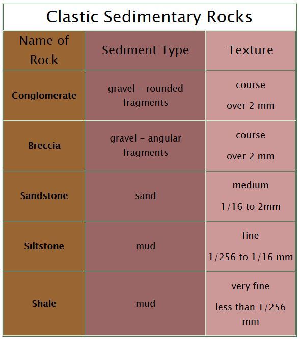
(Table sourced from rocksandminteral4u)
To log this Earthcache
Part A:
Examine the rock at ground level (just above the water line) at the first set of coordinates. The rock in question if predominantly grey,
Using your sense of touch, try to work out what type of rock it is (from the five types in the left column of the table).
Part B:
Walk (or rock-hop) about five meters further on to the second set of coordinates. Here you will see clearly defined layer upon layer of different sedimentary rock.
Your task here is to describe (using the above table as a reference) what you can see in THREE different layers in the cliff face in front of you.
Part C:
Take of photo of yourself OR your GPS to show a view of GZ. Include it in your message, but please do not post it in your log, it might give too much away.
When you have your response to the above questions, please, if possible, MESSAGE us, using the link at the top of the page underneath the name of the Cache. We prefer the MESSAGE method, as apparently, we don't respond to emails very well, but messages we do. We will contact you by MESSAGE once your MESSAGE has been received. But you can log your find in the meantime, and just say that you have MESSAGED your answers to the COs.
Happy Earthcaching!