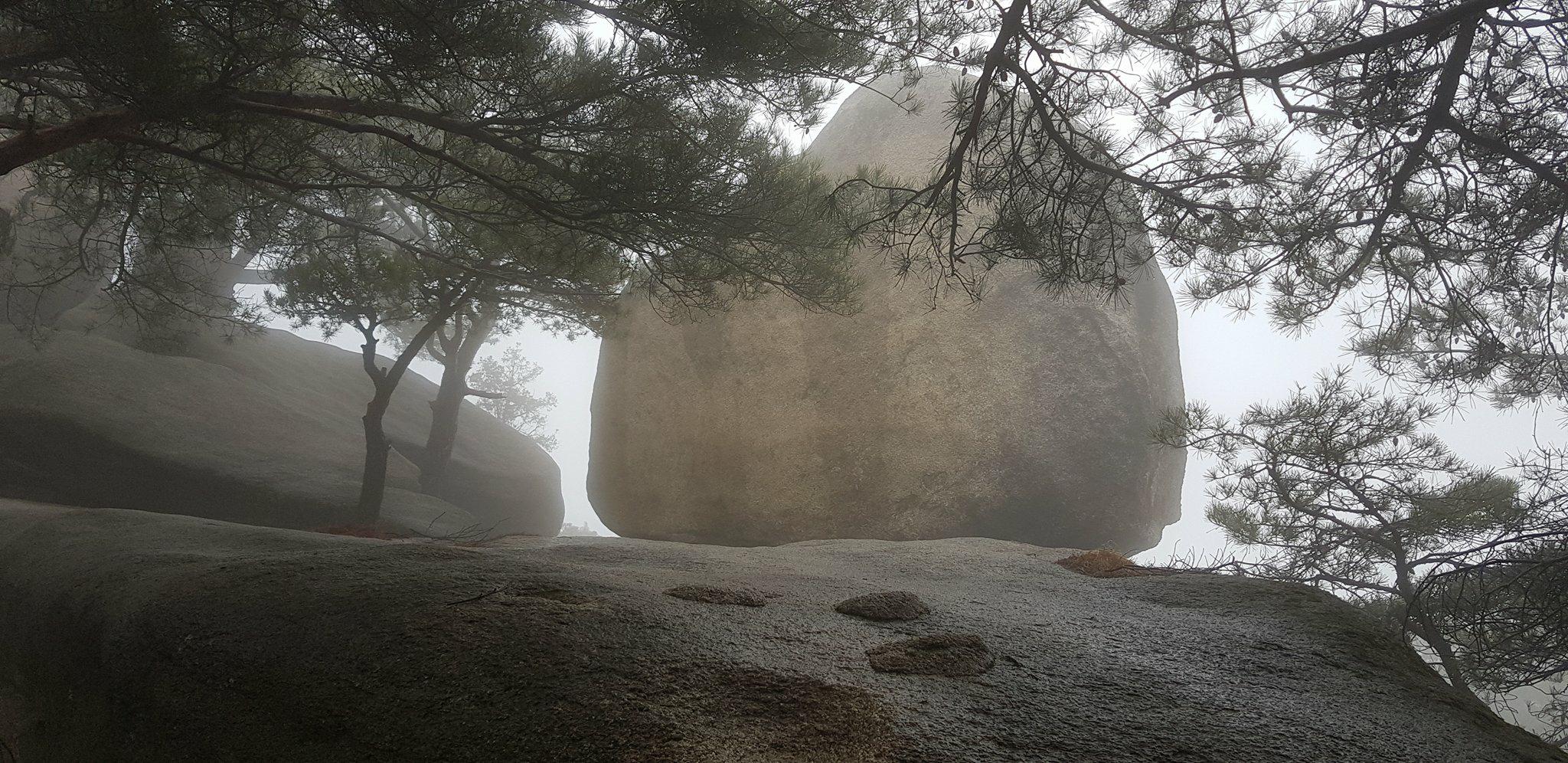
Skirt Rock on Surak Mounatin 치마바위 수락산
Granite in Surak Mountain is biotite granite with colors mostly white to a little pink. The granite was formed 173 million years ago during the Mesozoic Era. The magma intruded into the gneiss stratum and became the granite after being slowly cooled down. The granite rose slowly and the rocks above the granite were eroded, leaving the landscape we see today. Granite is much harder than the gneiss and erosion washed away the gneiss surrounding the granite. Surak Mountain is 637 meters high, although Skirt Rock sits slightly below that in altitude.
수락산의 화강암는 흑운모 (biotite) 화강암으로 주로 분홍색이 약간 희끗 희끗합니다. 화강암은 중생대 시대에 1 억 7300 만 년 전에 형성되었습니다. 마그마는 편마암 층에 침투하여 천천히 식은 후 화강암이되었다. 화강암은 천천히 올라 갔고 화강암 위의 암석은 침식되어 오늘날 우리가 볼 수있는 풍경을 남겼습니다. 화강암은 편마암보다 훨씬 힘들고 침식은 화강암을 둘러싼 편마암을 씻어 낸다. 수락산은 높이가 637 미터인데, 치마바위은 고도보다 약간 아래에 위치합니다.
Xenolith 포획암
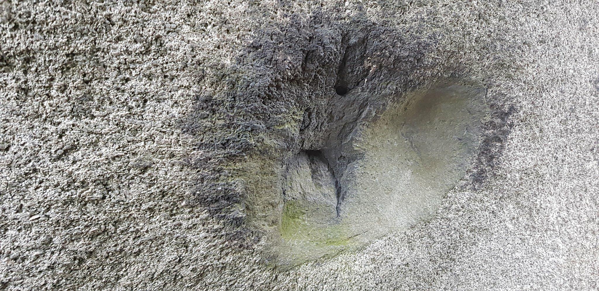
You can observe a xenolith very close to the posted coordinates. It was very dangerous to climb up to get perfect coordinates, but the xenolith can be easily found, as it is quite large. You may also use the picture attached to help locate it. It is within 1 or 2 meters of the posted coordinates. A xenolith is a rock fragment which becomes enveloped in a larger rock during the latter's development and hardening. In geology, the term xenolith is almost exclusively used to describe inclusions in igneous rock during magma emplacement and eruption. Xenoliths may be engulfed along the margins of a magma chamber, torn loose from the walls of an erupting lava conduit or explosive diatreme or picked up along the base of a flowing body of lava on the Earth's surface.
The xenolith is different from enclaves. Enclaves are volumes of rock surrounded by emplaced host rock of related, but distinct composition and of separated genesis (incomplete magmatic mixing). You can see a fine grained rock embedded in the host rock as if it were an impurity. That is 'Enclave'. When the magna that later became the host rock was cooling down the hotter mafic magna penetrated into it and caused an explosion. Enclaves are the fragment of these explosions.
게시 된 좌표에 매우 가까운 제노아리스를 관찰 할 수 있습니다. 그것은 완벽한 좌표를 얻기 위해 올라가는 것은 매우 위험한 일 이었지만, 꽤 큰 것처럼 포획암는 쉽게 발견 될 수 있습니다. 첨부 된 그림을 사용하여 찾을 수 있습니다. 게시 된 좌표의 1 ~ 2m 이내입니다. 크세 노리 스 (포획암)는 후자의 개발 및 경화 과정에서 큰 암석에 싸여있는 암석 조각입니다. 지질학에서, 용어 포획암는 거의 독점적으로 마그마 배치와 분화 동안 화성암에 함유 물을 기술하는데 사용된다. 포획암들는 마그마 챔버의 여백을 따라 휩싸이거나 분출하는 용암 도관이나 폭발물 수족관의 벽에서 찢어 지거나 지구 표면에 흐르는 용암 본부를 따라 집어 올 수 있습니다.
외국인 종은 고립 된 영토와 다릅니다. 고립 된 영토 (Enclaves)는 관련된, 그러나 별개의 구성과 분리 된 기원 (불완전한 magmatic mixing)으로 이루어진 공손한 호스트 락으로 둘러싸인 많은 양의 암석이다. 불순물 인 것처럼 호스트 바위에 묻혀있는 섬세한 암석을 볼 수 있습니다. 그것은 '고립 된 영토'입니다. 나중에 호스트 바위가 된 웅장한 마그마가 더 뜨거워 져서 마그마가 침투하여 폭발을 일으켰습니다.
Tors and Gnammas 토르와 나마
A tor is a rock outcrop formed by weathering, usually exposed on or near the ridge or summit of a hill. These landforms are formed either by sub-areal or underground deep weathering, which indicated the past climatic conditions while they are formed. Periglacial and subtropical types are major varieties of these features.
토르 (tor)는 풍화로 형성된 암석 노두입니다. 일반적으로 산등성이 또는 언덕 꼭대기 또는 근처에 노출됩니다. 이 지형들은 하위 지형 또는 지하 깊은 풍화에 의해 형성되며, 형성되는 동안 과거의 기후 조건을 나타냅니다. Periglacial과 아열대 유형은이 특징의 주요한 다양성이다.
A depressed, erosional feature found on at or gently sloping rock. Gnammas are the result of long-term chemical weathering, which is enhanced by the water in closed basin. They are known to be common in subtropical region; however, the term now includes the features formed by frequent freezing and thawing in cold region.
땅 속에서 그 초기 형태가 만들어지는 나마는 지하의 풍화 기저면에서 암석 표면의 특정 부분에 차별 풍화가 집중적으로 이루어져 요지 모양이 된다. 이후 표토가 제거되어 지표에 모습을 드러내면 이 요지에 물이 고이고, 그 물이 얼고 녹기를 반복하면서 암석을 구성하고 있는 광물 조각들이 하나 둘 씩 분리, 파괴된다. 이 때 풍화를 많이 받는 가장자리 부분을 따라 구멍이 점차 확대되는데, 특히 해안에 위치한 이곳 바닷물의 염분이 광물 입자 사이에 집적하여 입자 간의 틈을 더욱 벌리기 때문에 풍화가 빨리 진행된다. 또한 구멍에 해초가 들러붙어 기생하면서 암반의 균열된 부분에 침입하여 광물 입자들이 보다 쉽게 떨어져 나간다. 식물체에서 분비되는 유기산이 암석의 광물들과 화학적 풍화를 일으켜 나마가 확대되는 것이다.
[How to log]
1. What type of rock is the xenolith IN as shown in the picture below at the posted coordinates? How was this type of rock formed?
 1.2. HOW was this xenolith formed inside the rock type that you learned from the previous question?
1.3. How big is the xenolith? (Aproximate size. You can use your hand, cell phone, or GPS for comparison)
2. What geological features can you observe at that this earthcache was named for? Hint: it is the first picture on this page! (for example, Tor/Gnamma)
3. What type of feature do you see at Waypoint 1? Is it a Tor, Gnamma, or Xenolith?
Upload the photo of you or your GPS with the xenolith from the first picture in the background!
(The task is optional but I would highly appreciate if you would do so. You could also upload a picture from one of the beautiful rock features nearby and post it with your log.)
Please send your answers for the ther questions to me via a message on my profile! You may log as 'Found'.
If the answer is not correct, I will contact you.
[로그하는 방법]
1. 게시 된 좌표에서 아래 그림과 같이 포획암는 어떤 유형의 바위입니까? 이런 종류의 암석은 어떻게 형성 되었습니까?
1.2. 이전의 질문에서 배운 암석 종류 안에서이 암석층은 어떻게 형성 되었습니까??
1.3. 제노리스는 얼마나 큰가요? (근접 크기, 비교를 위해 손, 휴대 전화 또는 GPS를 사용할 수 있음)
2. 이 지중해가 지질 조사에서 지질 학적 특징을 관찰 할 수 있습니까? 힌트 :이 페이지의 첫 번째 사진입니다! (예: 토르/나마)
3. Waypoint 1에서 어떤 유형의 지형지 물이 보입니까? 그것은 토르 (Tor), 감마 (Gnamma), 또는 크 노리스 (Xenolith)입니까?
배경에 포획암가있는 당신이나 당신의 GPS 사진을 업로드하십시오!
(작업은 선택 사항이지만 그렇게 할 경우 매우 감사 드리며 근처의 아름다운 바위 기능 중 하나에서 사진을 업로드 할 수도 있습니다.)
답을 제 Profile에 있는 메시지창을 이용해 제게 보내주세요.
이제 로그하셔도 됩니다.
답에 문제가 있을 경우 제가 메시지를 드리겠습니다.