A short walking/exercise trail at the bottom of what was once the dam for the South Fork Fishing and Hunting Club.
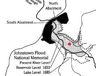
The trail is located in the 1889 Park adjacent to the Disaster’s Edge Environmental Center, managed by the Cambria County Conservation District. The cache location will place you approximately 20 feet below the water level at which the Lake was managed for the Pennsylvania Canal and 35 feet below the level that the South Fork Hunting and Fishing Club raised it to. The red mark on the attached pic shows how far you’ll be from shore, so hopefully you can hold your breath for a while. Picnic pavilions, restrooms, a coal museum, ballfield, and a campground are available in the Park. After the cache, take some time to visit the actual dam site within the Johnstown Flood National Memorial Site - https://www.nps.gov/jofl/index.htm, the Visitor’s Center, or a driving tour of the St Michael Historic District with the 1889 Clubhouse (all free). Or, for more information on the flood history of Johnstown, visit www.visitjohnstownpa.com! For an additional cache related to the Flood, visit Another Other Unknowns, https://www.geocaching.com/geocache/GCJFWW_another-other-unknowns.
 *****There is a peanut butter jar type container placed near the bench. THIS IS NOT THE GEOCACHE! It is close by, but not on the ground!!*****