Geological background
 The Devonian (Frasnian) Portscatho Formation is dominantly composed of alternating grey or greenish grey, sandstones and mudstones (slates) along with less abundant siltstones. The Mylor Slate Formation is well developed around Carrick Roads and is dominated by dark grey slates with thin pale grey sandstones and siltstones. This rock unit is also Devonian (Famennian) in age. The Porthleven Breccia Member is included within the Mylor Slate Formation, but comprises angular fragments of a range of rock types included within mudstones. Locally igneous rocks (originally basaltic in composition, but altered during regional metamorphism to what are referred to in Cornwall as greenstones) occur in amongst the Devonian sediments. All of these Devonian rocks were folded and regionally metamorphosed during a major mountain building event known as the Variscan orogeny some 350-290 million years ago.
Subsequently large granite masses were emplaced into the Devonian rocks. Two large granite bodies occur within the catchment area of the Fal Estuary; the Carnmenellis Granite to the west and the St. Austell Granite to the east. The Carnmenellis Granite is roughly circular in outline and is predominantly composed of muscovite-biotite granite. To the east of the estuary is the St. Austell Granite. This granite is composed of three main textural and lithological varieties; the eastern part is largely composed of biotite granite, whilst the western part is composed of topaz granite and tourmaline granite. The tourmaline (or lithium-mica) granite is extensively altered to kaolinite. The topaz granites occur as well defined bodies within the St. Austell Granite. (SOURCE: HERE)
What is stratigraphy?
Stratigraphy is basically the study of rock layers and layering (stratification). It is primarily used in the study of sedimentary and layered volcanic rocks. The subject was essentially invented and first rigorously applied by William Smith in England in the 1790s and early 1800s.
Stratigraphy includes two related subfields: lithologic or lithostratigraphy and biologic stratigraphy or biostratigraphy. Lithostratigraphy, or lithologic stratigraphy, is the most obvious. It deals with the physical lithological or rock type change both vertically in layering or bedding of varying rock type and laterally reflecting changing environments of deposition, known as facies change. Key elements of stratigraphy involve understanding how certain geometric relationships between rock layers arise and what these geometries mean in terms of depositional environment. One of stratigraphy's basic concepts is codified in the Law of Superposition, which simply states that, in an undeformed stratigraphic sequence, the oldest strata occur at the base of the sequence.
Biostratigraphy or paleontologic stratigraphy is based on fossil evidence in the rock layers. Strata from widespread locations containing the same fossil fauna and flora are correlatable in time. Biologic stratigraphy was based on William Smith's principle of faunal succession, which predated, and was one of the first and most powerful lines of evidence for, biological evolution. It provides strong evidence for formation (speciation) of and the extinction of species. The geologic time scale was developed during the 1800s based on the evidence of biologic stratigraphy and faunal succession. This timescale remained a relative scale until the development of radiometric dating, which gave it and the stratigraphy it was based on an absolute time framework, leading to the development of chronostratigraph.
Measuring stratigraphy
· One way to think of the strike is it represents the compass direction (azimuth) of the trace of a layer across the surface of the Earth, if the surface is approximately horizontal. This means a measurement of the strike will tell you the direction a layer should appear on a geological map.
· The dip is the angle of inclination of the layer with respect to the surface. This angle is measured perpendicular to the strike.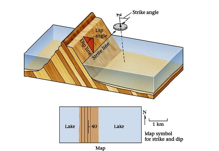
Measuring strike:
We will begin by taking the strike of a bedding plane. For these measurements we will use a Brunton compass like the one you see in the pictures above. In order to measure the strike, place the side or edge of the compass against the plane of the outcrop. Sometimes it is easier to put your field book against the outcrop and then the compass against the book to get a smoother and/or a larger surface. Now, rotate the compass keeping the lower side edge of the compass fixed, until the bulls-eye level bubble is centered (the round tube; not the long narrow one). When the bubble is centered, the compass is horizontal against the plane and parallel to the line of strike. Now, with the bulls-eye bubble centered, record the number that either end of the compass needle is showing.
In other words:
- Place the bottom EDGE of the compass flat against the plane of interest.
- Adjust the compass orientation, making sure the bottom edge is always flat against the plane, until the air bubble in the "Bull's eye level" is centered.
- Read either end of the compass needle to obtain the value of strike.
Measuring Dip:
To measure the dip of the bedding plane, take your compass and put its side against the rock so that it points in the same direction as the line of dip (The dip line is perpendicular to the strike line). Move the clinometer until the clinometer level bubble is centered. As we did when we found the strike, record where the white tipped end of the clinometer needle is pointing. Note the degrees and the direction. Recall that the dip direction MUST always be perpendicular to the strike direction (e.g., a strike of 40° could only dip to the SE or NW, never NE or SW)
In other words:
- AFTER you determine strike, rotate the compass 90°.
- Place the SIDE of the compass flat against the plane.
- Adjust the lever on the back of the compass until the air bubble in the "Clinometer level" is centred.
- Read the dip directly from the scale in the compass.
Claiming the earthcache
To claim this earthcache you will be confronted with a stratigraphical sequence of the Portscatho Formation. This spot has been chosen specifically because the outcrop is large enough to walk on and you can choose multiple poins to measure dip and strike. Also, there are no geological complications and you can see the strata in cross section, i.e. WYSIWYG (what you see is what you get). What I need you to do is to measure:
1- strike (here a simple compass point will do, e.g. N-S, E-W, etc.)
2- dip. Where to the strata dip (landward or seaward and by how much - this is where you need your clinometer)
(There are several free apps that will measure dip. However, it is always fun to do it the old fashioned way)
You will need a compass (I will accept a simple N, S, E or W or any variation in between) and a clinometer. There is no need to get a fancy instrument. A simple clinometer can be fashioned using a plastic protractor and a string with a weight attached.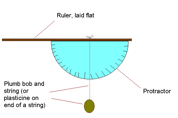
Have fun!

|
 The most exciting way to learn about the Earth and its processes is to get into the outdoors and experience it first-hand. Visiting an Earthcache is a great outdoor activity the whole family can enjoy. The most exciting way to learn about the Earth and its processes is to get into the outdoors and experience it first-hand. Visiting an Earthcache is a great outdoor activity the whole family can enjoy.
An Earthcache is a special place that people can visit to learn about a unique geoscience feature or aspect of our Earth. Earthcaches include a set of educational notes and the details about where to find the location (latitude and longitude). Visitors to Earthcaches can see how our planet has been shaped by geological processes, how we manage the resources and how scientists gather evidence to learn about the Earth. To find out more click HERE.
|