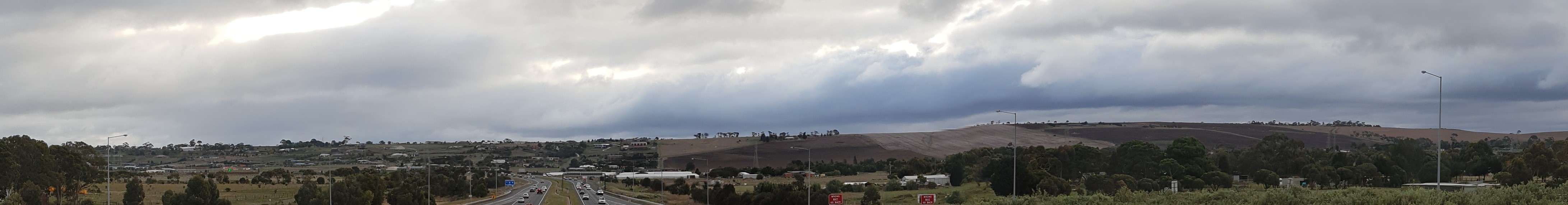
More than just a hill
A Sims_family's Cache
The Lovely Banks Monocline
The Lovely Banks monocline is a persistent linear feature with increasing expression in the landscape towards the south. It is a clear example of a geomorphological feature determined by a tectonic structure.
What is a Monocline?
A monocline is a step-like bend in rock strata, causing a steeper dip in an otherwise horizontal or gently sloping landscape. Often associated with underlying faults in deeper rocks, monoclines are caused by similar forces, but the strata bend rather than fracturing.
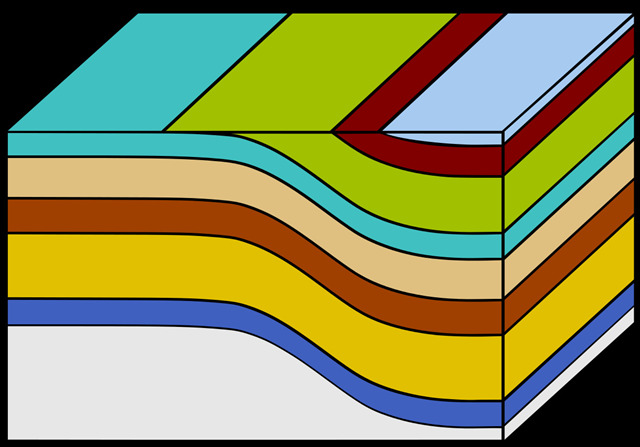 a pictorial representation of strata folds forming a monocline
Description of the Lovely Banks Monocline
Trending south-southeast from the easternmost of the Anakie volcanoes is an east facing escarpment that is the surface expression of the Lovely Banks Monocline. The monocline is an important tectonic structure that together with the Rowsley Fault Line, forms the western margin of the Port Phillip Sunkland. To the east there is a marked reduction in the elevation of the lava plains south of the You Yangs. In the north the monocline is approximately in line with the Anakie volcanoes and may lie along the same fracture plane at depth.
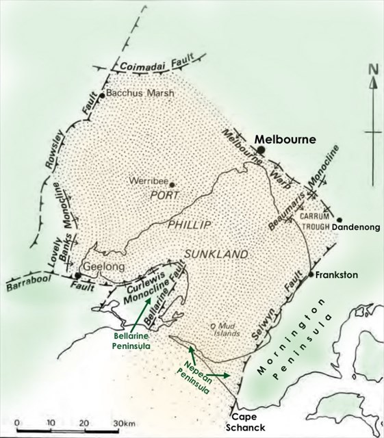 Port Phillip Sunkland
At Anakie East, the escarpment is only 10 - 15 m high, but the displacement increases rapidly towards the south so that at Lovely Banks the monocline is quite a substantial feature. The most recent movement on the monocline post dates the eruption of the volcanoes so that lava flows are warped over the monocline scarp.
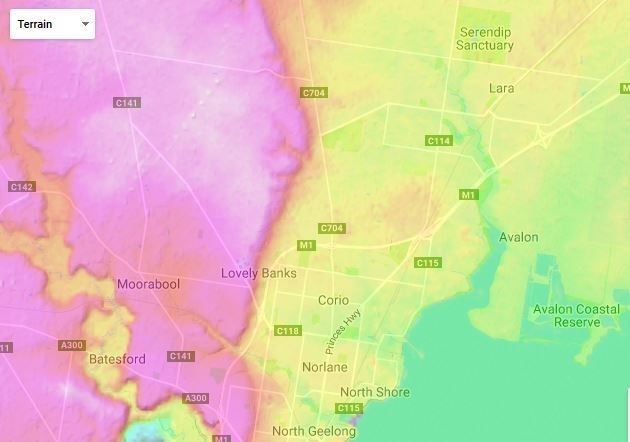 topological map of the area clearly showing the monocline
A Victorian Government report concludes with the suggestion, ' it will be necessary to keep buildings or other obstructive structures away from the crest and slopes so that the displacement can be readily appreciated.' However, zoning of the land in the area already allows for further development all the way through to Staceys Rd, so in time the monocline may become difficult to recognise. Travelling along any of the roads that cut across the monocline in an east-west manner is one way to easily sense the slope of the monocline with plateaus top and bottom.
Logging Requirements
To log this cache you must send your answers to the following questions via the "message this owner" option at the top of the cache page.
Your task today is to go to the listed co-ordinates. Take a moment to look north and south along the monocline. It stretches as far as you can see in both directions, and really is 'more than just a hill'! Next, travel up the hill to WP2
Q1. Estimate the difference in elevation between the top and bottom of the monocline along this road. Do you think this difference is caused by the area to the east (Port Phillip Sunklands) dropping or the area to the west rising?
Q2. Take a look at the area behind the service station complex. What activities have / are taking place that are slowly changing the monocline?
Sources
http://vro.agriculture.vic.gov.au/dpi/vro/portregn.nsf/pages/werribee_gg_significance_bf1
Oxford Dictionary http://bio-geo-terms.blogspot.com.au/2006/12/monoclines.html https://en.wikipedia.org/wiki/Monocline
Structure and Surface: The Geology and Geomorphology of the Sandringham District by Eric Bird 1990
http://en-au.topographic-map.com/
http://written-in-stone-seen-through-my-lens.blogspot.com.au/2011/08/flight-plan-part-i-geology-of-san.html