[IT]
Alle coordinate del listing si trova questa formazione incredibile. Un muro di sabbia compressa spesso circa 1 metro e alto una decina di metri.
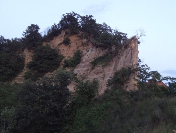
Le Rocche hanno una lunga storia. Per scoprire come si sono formate bisogna tornare indietro nel tempo di circa 20 milioni di anni fa. All'epoca intera valle del Po era coperta dal mare e nel corso di milioni di anni sul fondo di questo lembo di mare si sono formate le dune di sabbia. Questa sabbia contiene anche i vari fossili, testimoni di quest'epoca.
Successivamente il mare si ritirò e il fiume Tanaro, che fino a circa 40000 anni fa scorse proprio qui, scolpì questi canyon nel terreno piuttosto morbido.
Il terzo evento geologico che ha fortemente influenzato tutta la zona avviene circa 40000 anni fa. Il fiume Tanaro, che fino a quel tempo andava verso nord e raggiungeva il fiume Po nei presi di Carmagnola, ha cambiato il corso e nei presi di Cherasco ha preso la direzione est raggiungendo il Po nei presi di Alessandria.
La 'cattura' del fiume Tanaro è per sè un fenomeno piuttosto interessante, vedi il pannello informativo sul posto. Questo caso particolare e' uno dei casi di cattura fluviale tra i meglio studiati al mondo.
Nella zona sono rinvenuti anche numerosi fossili, vedi il secondo pannello informativo
Per poter loggare questo earthcache devi rispondere alle seguenti domande e mandarmi le risposte tramite il sistema messaggistico di geocaching oppure via mail.
- Quanti anni fa si sono formate le Rocche?
- Quante specie di fossili sono stati trovati nello scavo?
- Spiega con tue parole come avvenì la "cattura" del fiume Tanaro.
Tutte le risposte si trovano sui pannelli informativi.

[EN]
This incredible formation can be found at the coordinates of the listing. A wall of compressed sand about 1 meter thick and about ten meters high.
The Rocche have a long history. To find out how they are formed we need to go back in time about 20 million years ago. At the time, the entire Po valley was covered by the sea and over the course of millions of years the sand dunes were formed at the bottom of this strip of sea. This sand also contains the various fossils, witnesses of this era.
Subsequently the sea withdrew and the river Tanaro, which until about 40,000 years ago saw it right here, carved these canyons in rather soft terrain.
The third geological event that strongly influenced the whole area takes place around 40,000 years ago. The river Tanaro, which until that time went north and reached the river Po in the outskirts of Carmagnola, changed the course near Cherasco and took the eastern direction reaching the Po near Alessandria.
The 'capture' of the Tanaro river is a rather interesting phenomenon for itself, see the information panel on site. This particular case is one of the cases of fluvial capture among the best studied in the world.
Numerous fossils have also been found in the area, see the second information panel.
To log this earthcache you have to answer the following questions and send me the answers through the geocaching messaging system or via email.
- How many years ago were the Rocche formed?
- How many fossil species were found in the excavation?
- Describe the process of "Capture" of Tanaro river.
All the answers can be found on the information panels.