
***THIS IS AN EARTHCACHE***
***There is no container at the posted coordinates***
***You will need to submit answers to the questions below in order to claim this geocache as a find.***
***This geocache is located on the grounds of Sebago Lake State Park but NOT within the paid/fee portion of the park; you do not have to pay anything to visit this geocache.***
Maine has experienced at least four "ice ages" (periods during which accumulated snow from higher latitudes became so compacted as to slowly flow across the land under its own weight, advancing as glaciers) during the Pleistocene epoch (the most recent one million years of Earth's history). During each of these events, which may have lasted 70,000 years or more, enormous ice sheets advanced across the land, scraping away soil and rocks, carving and reshaping the landscape beneath. As each period of glaciation (or "ice age") ended and the ice gradually melted away, not only were valleys and lakes created but rocks and boulders were often left deposited in locations far from their place of origin. These rocks and boulders are referred to as glacial "erratics." (Or, as a friend of mine likes to refer to them, "glacial spew"). 😀
The area represented here was once a gravel pit many decades ago, and it was during this time that this erratic was discovered. Measuring approximately 5 x 10 x 12 feet (1.5 x 3.0 x 3.5 meters), the erratic is estimated to weigh over 27 tons (24 metric tons/tonnes) and is comprised of argillite, a metamorphic rock. There are no large masses of argillite in this region, leading to the determination of this boulder being a glacial erratic.
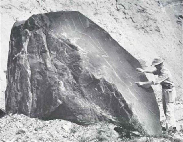
The glacial erratic in 1959.
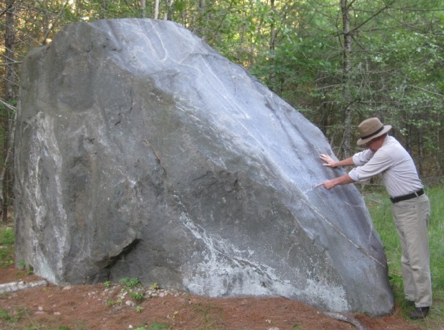
The glacial erratic in 2018.
"As a huge stone is sometimes seen to lie
Couched on the bald top of an eminence;
Wonder to all who do the same espy,
By what means it could thither come, and whence;
So that it seems a thing endued with sense:
Like a sea-beast crawled forth, that on a shelf
Of rock or sand reposeth, there to sun itself.
----------------------William Wordsworth, The Leech-gatherer, 1807
Do not park on State Park Rd or Thompson Point Rd near the trailhead leading to the EarthCache. There are "No Parking" / "Tow Away" signs posted. Parking is available just a short distance away (directly across from Songo Lock Snack Bar) (closed for the past few years), adjacent to the Songo Lock (a State Historic Site which will offer a unique and interesting experience if you have some spare time and have never seen a waterway lock in operation before) (and if you are here during the summer season).
From the parking location, walk across the bridge (be careful of traffic!) and continue toward the opposite side of the triangle formed by the meeting of Thompson Point Rd as it split-intersects with State Park Rd. On the west split of the Thompson Point Rd portion of the triangle, look for an access trail leading south into the woods. It is marked with a small sign on a tree, reading "This state park is closed to hunting." (Sign posted as of Summer 2018). (Fall 2021: looks like sign is now missing). From here, it is only a short walk to your destination. In fact, you might already be able to catch a glimpse of it from this point, depending on vegetation.
In order to claim this cache as a "find," please perform/answer the following:
1). Send me an email or message with "Glacial Spew," "Glacial Erratic," or "EarthCache" as the Subject, and tell me how many are in your group.
2). Considering that many of the lakes just north of this area are oriented from northwest to southeast (Long Lake, Brandy Pond, Highland Lake, Moose Pond, Woods Pond, Pleasant Lake, Thompson Lake, Pennesseewassee Lake), from which direction do you think this glacial erratic came and why?
3). If you arrived at the site from the access trail heading south from the area of State Park Road, and consider the north-facing side of the erratic to be the front, look on the back side (south side) of the erratic. Are there any white-colored quartz veins visible, and if so, do any of the veins intersect one another, or are they all parallel?
4). Do you think your answer to Question #3 above has anything to do with how this erratic arrived here, and why or why not?
5). Stand at the west end of the erratic so that you are facing it at its "thinnest" point, and examine the portion of the boulder that slopes down toward the ground. Other than white quartz veins, do you see any other color(s) represented? If so, what color(s)?
6). (Optional) When you post your online log, include a photo of your GPS, yourself, or your group in front of the erratic.
Answers to EarthCache questions should be sent to the Cache Owner BEFORE you log the cache. If you are unable to send the answers remotely, then technically you should wait until after you do send the answers before logging the cache. However, I'm willing to be flexible, providing you still send the answers within a reasonable amount of time. Logs without an accompanying email having been sent to the Cache Owner (or without responding to pending questions from the C.O.) will be deleted with no further notice.
Thanks for taking the time to visit this EarthCache! Grateful acknowledgement is given to the Maine Geological Survey and their publication The Geology of Sebago Lake State Park by Arthur L. Bloom, 1959 (public domain), as well as to the park managers of Sebago Lake State Park, under the division of the Maine Department of Agriculture, Conservation & Forestry, Bureau of Parks & Lands.
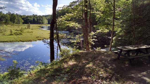
FYI, if you're interested, you can continue along the trail another 50 yards or so and it will go over a small ridge and you should see a single picnic table where this access trail joins with the yellow-diamond-marked Songo Wilderness Trail. The view here of Horseshoe Bog is beautiful and it would be a perfect spot for a snack or lunch. Note: there are no trash cans here so please be sure to take any trash back out with you. (There is also another geocache at this location, "Picnic at the 'Shoe" - GC14098)
Nearby picnic area.
- - - - - - - - - -
| I have earned GSA's highest level: |
 |
- - - - - - - - - -
* * * Congratulations to "mainezonie" for being FTF!! * * *