A Winter Walk by Brisbane Water
Sunday, 1st July

Geocaching NSW would like to invite all geocachers to attend our next event - a walking event on the Central Coast.
The event itself is an informal meet and greet, “BYO everything” picnic. Those who attend will have the opportunity to meet new people and make new friends with a common interest, pick up the latest information on equipment, techniques and software, share stories about the latest caching adventure and swap travel bugs and geocoins. You may even pick up a hint on those pesky DNFs or get a clue or two on how to solve a puzzle cache you’ve been stumped on. For those cachers who just want to attend the event, it officially commences at 11:00am at the published coordinates at Lions Park in Woy Woy.
Our large white “Geocaching NSW” banner and portable gazebo will be located at the published coordinates. At least one member of the Committee will be in attendance at the published coordinates for the duration of the event, including the timing of the walk. A group photo will be taken at 12:30pm so hope you can be there for that.
Festivities will commence at 11:00am (however, for the walk - see below) and conclude at 1:00pm.
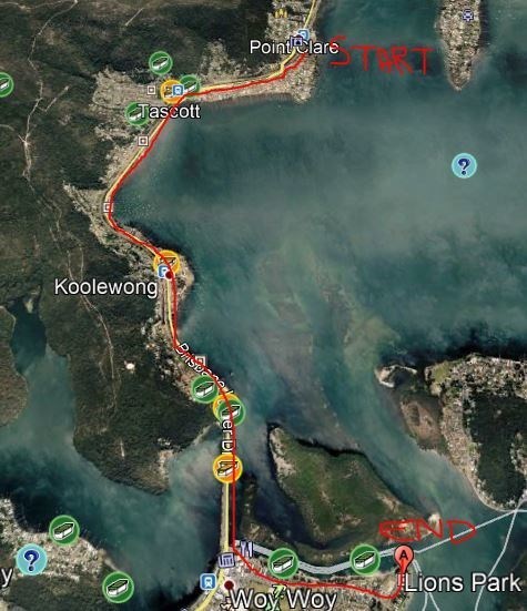
The Walk (Point Clare to Woy Woy):
The walking component of the event is optional and does not need to be completed as a requirement for an attendance smiley. The walk commences on the eastern side of Point Clare Station (for coordinates, refer to the Waypoint, below).
Walk meet: 10:00am. Commences: 10:15am.
Conclusion of walk at the (published) event location: approximately 12:00pm, if not earlier.
Distance: approx. 6.0 km.
The walk is a mostly flat path that follows the coastline, however allow for occasional patches of uneven surfaces and potentially some areas with higher terrain than that for the event. Make sure you wear sturdy shoes and suitable clothing for the weather. It would also be advisable to bring a hat and sunscreen, as well as some water and snacks for yourself.
Transport:
Waypoints for Point Clare Station (the start of the walk) and Woy Woy Station have been included. Note that Woy Woy Station is approximately a 1.4km walk from the event location.
If you plan to park at Woy Woy and catch the train up to the start of the walk, a train leaves Woy Woy at 9:59am and arrives at Point Clare station at 10:08am. For those that want to get this same train all the way from Sydney, it leaves Sydney Terminal (Central) at 8:46am. Don't forget your Opal cards! Being a Sunday, all later trains are running every hour after these times, e.g. for those just going to the event.
Number 55 and 70 buses run between Woy Woy and Point Clare.
A map of the route of the walk is shown here.
The walk takes in the following caches along the way:
commuters cache (GC3Y78J)
Tour of Tascott (GC68163)
Gateway to Koolewong (GC3CCYR)
Deep Water (GC7HZJJ)
Heni Beach (GC7HZY9)
Here’s hoping you can join us for a fabulous day of geocaching friendship.
Cheers,
Geocaching NSW Committee