The posted coordinates will take you to a spring in the Springvale Mud Spring Nature Refuge.
The spring is part of the Eulo Springs ‘super-group’, one of 11 ‘super-groups’ of Great Artesian Basin springs.
Formation of springs in the Great Artesian Basin
The Great Artesian Basin (GAB) underlies around 23% of the Australian continent and is estimated to contain 64,900 cubic kilometres of groundwater, making it one of the largest artesian groundwater basins in the world.
The water of the GAB is held in sandstone laid down millions of years ago. The sandstone was then covered by a layer of marine sedimentary rock, which formed a confining layer, thus trapping water in the sandstone aquifer.
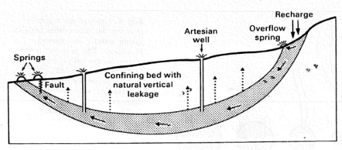
Water continues to enter these sandstone aquifers along higher exposed edges, mostly along the Great Dividing Range. This recharges the aquifers and the water continues to slowly flow downhill from the uplifted edges, mostly towards the inland.
Water pressure builds up from both the gravity input and the weight of the rock. In some places the pressure forces the water up through cracks to form springs.
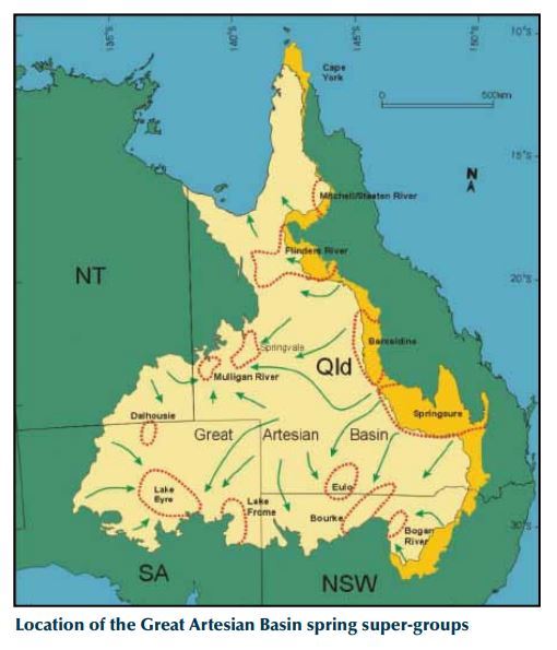
Eulo Springs ‘super-group’
Springs comprising the Eulo ‘super-group’ occur across a 150 by 100 kilometre area roughly bounded by the towns of Eulo, Hungerford and Thargomindah in south-western Queensland.
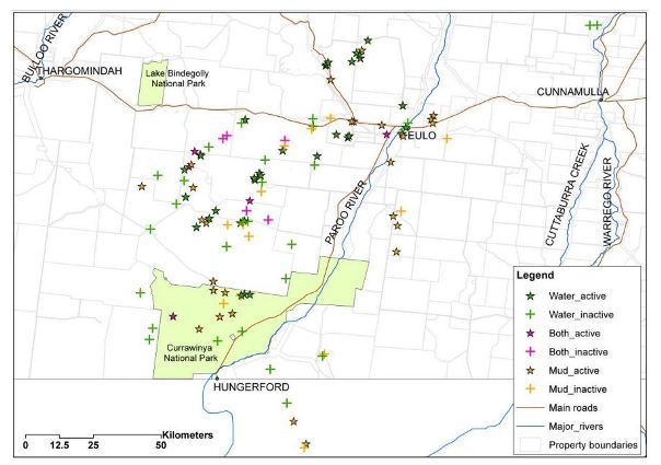 Eulo 'super-group' showing active and inactive mud and water springs.
'Both' means that active and inactive springs occur together.
Eulo 'super-group' showing active and inactive mud and water springs.
'Both' means that active and inactive springs occur together.
The Eulo springs complex is primarily attributable to shallowing of the aquifers due to elevated underlying granitic basement structures.
Springs in the Eulo ‘super-group’ can appear as open pools of free water, vegetated springs or mud springs. Though mud springs are considered to be very rare in Queensland, they are more common in this 'super-group' than in any other area in Queensland.
Mud, glorious mud!
Most mud springs are mounded and can occur as single isolated mounds, in small clusters or cover large areas up to 10-square kilometres containing hundreds of vents.
The mud springs in the Eulo region are composed of mineral-rich clay-mud that has been slowly transported to the surface by the pressurised artesian water from the sandstone aquifer. They are usually roughly conical in shape, up to several metres high. Most are no longer active although some have artesian water pools in and around them, which indicates they are still active. Another indicator that groundwater is still flowing is a ‘wobbly’ mud surface, particularly in the centre of the cone. The mound springs do not usually support vegetation.
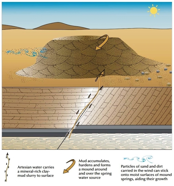
Mound formation is closely related to water discharge rate, sediment load and the nature and concentration of salts in solution.
Craters occasionally occur – they probably result from deflation following the demise of some mud springs.
There have also been records of pressure within some mounds building up to the extent that they occasionally (and surprisingly!) burst into life and emit mud. Mounds in the Eulo area have popped up within the past decade, whereas others ‘spew’ out mud sporadically but may lie dormant for years. There are reports of mud springs ‘exploding’ with ‘loud bangs’ in the Eulo area.
Mud springs eternal?
Springs are an important permanent water source in this semi-arid region for Aboriginal people and pastoralists. They support specialised plants and animals that are found nowhere else in the world and have very high conservation value. The Eulo springs are also valuable for their fossil and archaeological deposits.
Water extraction, through the sinking of thousands of bores across the GAB, has caused a substantial decrease in water pressure and spring flow. It is estimated that approximately 40 per cent of discharge spring complexes in the GAB have become inactive due to this water draw down. The Eulo springs 'super-group' is one of the most severely affected, with half its 61 spring complexes now completely inactive and a further 22 only partially active. Only eight spring complexes remain entirely active, and their discharge rate is about a third of the volume they discharged in the early 1900s.
To log this earthcache...
To log the cache, please send me a message or email with answers to the following questions:
Q1. Describe what you see at the spring at the posted coordinates (e.g. shape, size, colour, composition, vegetation, water).
Q2. How does this differ from what you see at Spring 2 (Reference Point), and why do you think they are different?
Q3. Does the mud spring at the posted coordinates appear to be active or dormant? Explain your reasoning.
The answers can be determined from your observations at the spring at the posted coordinates and the reference point (ie Spring 2), and reading the above information.
Please feel free to log your visit as soon as you have submitted your answers to me. I will respond confirming permission to log, or asking clarifying questions if I feel that you have not answered the questions correctly. Logs with no answers sent will be deleted. Please do not post your answers in your log.
Enjoy your visit, and beware the exploding mud! 
References and further information:
https://wetlandinfo.ehp.qld.gov.au/resources/static/pdf/resources/tools/conceptual-model-case-studies/cs-eulo-supergroup-22-april-2013.pdf
https://www.environment.gov.au/system/files/resources/edd20074-c291-4df6-9a24-b98d24696378/files/gab-springs-survey-vol-1.pdf
http://www.southwestnrm.org.au/sites/default/files/uploads/ihub/mound-springs-great-artesian-basin.pdf