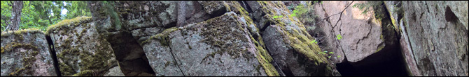
Laitilan Hautvuori on vaikuttava näky. Sen voimakkaasti halkeilleet kalliot muodostuvat kulmikkaista, toisiinsa nojaavista lohkoista, joiden väliin on muodostunut useita suuria luolia. Jyrkkäseinäinen ja rauniomainen vuori on toiminut pronssikaudella linnavuorena. Alueen historiasta löytyy lisätietoa kätkökoordinaateista löytyvästä infotaulusta.
Vuorelle on esitetty ainakin kaksi syntyteoriaa:
Vallitsevan teorian mukaan kalliot ovat tooreja. Toorin synty alkaa, kun paino kallioperän päällä vähenee sen pinnan kuluessa ja kulkeutuessa pois. Silloin maa alkaa kohota, mikä puolestaan aiheuttaa graniittiseen peruskallioon vaaka- ja pystysuuntaista halkeilua. Kun kovaa kalliota peittävä ja ympäröivä rapautunut kiviaines ja pienemmät lohkot kulkeutuvat pois, voi sopivasti halkeilleesta kalliosta jäädä jäljelle suurista lohkoista muodostunut, rauniomainen toorikukkula. Tämän teorian mukaan toorit ovat kehittyneet maan alla jo ennen viimeistä jääkautta, mutta ovat tulleet näkyviin ja jatkaneet kehittymistään jääkauden aikana ja jälkeen.
Vaihtoehtoisen teorian mukaan lohkoutumisen on aiheuttanut räjähdysmäinen metaanipurkaus. Kallioperän pieniin halkeamiin on jäänyt jääkauden jälkeen metaaniklatraattia eli vesijäätä, jonka kiderakenne sulkee sisäänsä metaanikaasua. Kovassa paineessa ja liikkumattomassa ympäristössä jää on pysynyt kiinteänä, mutta teorian mukaan kallioperän liikahdus voi aiheuttaa metaanikaasun nopean vapautumisen jään sisältä. Kaasuuntuessaan metaanin tilavuus 168-kertaistuu räjähdysmäisesti, mikä halkoo kallioita ja nostaa kivilohkoja hetkellisesti useiden metrien korkeuteen. Teorian mukaan räjähdykset ovat tapahtuneet viimeisimmän jääkauden jälkeen.
Tehtävät
Geokohteen löydetyksi loggaaminen edellyttää yllä esitettyihin teorioihin tutustumista sekä vierailemista referenssipisteissä A, B ja C (Kirkko, Huuhkajanpesä ja Linnankellari). Jokainen piste sijaitsee kallion juurella luolan suuaukolla. Tutki lohkoutumista vuoren seinämistä ja luolien sisältä ja vastaa vierailusi perusteella seuraaviin kysymyksiin. Lähetä vastauksesi kätkön tekijälle tästä.
- Kumpaa syntyteoriaa pidät uskottavampana? Perustele.
- Mikä kohteista A, B, C on mielestäsi edustavin valitsemaasi teoriaa edustava esimerkki? Perustele.
- Minkä luolan pohjalta voit löytää Litorinameren aikaista simpukkasoraa? Soran joukossa on pieniä simpukankuoren palasia.
Voit logata kätkön heti lähetettyäsi vastaukset. Loggaukseen liitetyt valokuvat ilahduttavat suuresti. Ethän spoilaa vastauksia loggauksessasi tai siihen liittämissäsi kuvissa.
The rocky hills of Hautvuori consist of large stacks of blocky granite between which can be found several caves. During the Bronze Age, the cracked, ruin-like hill has served as a fortress.
There are at least two theories for the formation of the hills:
According to the generally accepted theory, the hills are tors. The forming of a tor begins when rock on top of the granite bedrock weathers and is washed away. With less weight on top of it, the bedrock rises and cracks horizontally and vertically into blocks of stone. A tor may be formed when the cracking happens into suitably large blocks. The tor is revealed when more weathered rock and small blocks are washed away. This theory sets the formation of the tors before the last Ice Age.
According to an alternative theory, the cracking of the rock is a result of violent methane venting. Methane clathrate (i.e. water ice with methane gas trapped within its crystalline structure) has remained in small cracks of the bedrock since the last Ice Age. The ice remains solid in the high pressure as long as the rock around it is stable, but a small movement may cause the methane to be quickly released into gaseous form, expanding it to 168 times its previous volume. The gas is violently vented upwards, potentially cracking the bedrock and throwing stony blocks several meters into the air. According to the theory, these explosions have taken place after the last Ice Age.
Tasks
Logging this Earthcache as found requires getting acquaintanced with the theories above as well as visiting reference points A, B, and C. Each point is placed at the base of a cliff next to an entrance to a cave. Examine the cracking of the rock in the cliff faces and within the caves and answer the following questions. Please send your answers to the owner of this cache using this link.
- Which theory do you consider more plausible? Why?
- Which one of points A, B, and C is the best representative of the theory you picked? Why?
- Which cave has gravel made of ancient seashells at its bottom? Pieces of shells can be seen in the sand.
You may log the cache as found as soon as the answers have been sent. Photos included in the log are much appreciated. Please do not spoil the answers in your log.
Lähteet/Sources:
Kejonen Aimo & Kesäläinen Tuomo: Suomen luolat (2015).
Kontula et.al.: Suomen ympäristö 8, osa 2: Kalliot ja kivikot (2008).
Mörner, N-A: Methane hydrate in crystalline bedrock and explosive methane venting tectonics (2017).