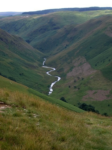
The Fifteen Mile Creek trail ends near the posted coordinates, at a viewpoint overlooking Fifteen Mile Creek. There is no need to step off the trail to observe the valley and answer the questions.
GENERAL GEOLOGY OF THE ISSAQUAH ALPS
The Issaquah Alps is the unofficial name for the highlands near Issaquah, Washington, a suburb of Seattle, including Cougar Mountain, Squak Mountain, Tiger Mountain, Taylor Mountain, Rattlesnake Ridge, Rattlesnake Mountain, and Grand Ridge. The term was invented in 1977 by noted nature author Harvey Manning within the pages of his trail guidebook Footsore 1, elevating their status from foothills to "Alps" to advocate preservation.
The Issaquah Alps follow Interstate 90 from the shore of Lake Washington almost to the western face of the Cascade Range. The hills are composed of andesitic volcanic rock lying on top of older tightly folded rocks from the coastal plain of the North Cascade subcontinent that docked with Washington about 50 million years ago as the entire continent of North America moved west across the ocean. The Alps were heavily eroded by glaciers in the last ice age. The Vashon lobe of the ice sculpted Rattlesnake Ledge, steeply carved the east and west sides of Squak Mountain, and deposited a large erratic on Cougar Mountain, Fantastic Erratic.
Excerpted from: https://en.wikipedia.org/wiki/Issaquah_Alps
VALLEY FORMATION OVERVIEW
Many, but not all, of Earth’s valleys are formed in one of two ways: water erosion or glacial erosion. A valley recently formed by water erosion (a “youthful valley”) may have a different shape than an older (“mature”) valley, and a valley shaped by glacial erosion has its own characteristic shape. By observing the shape of the valley, it is possible to infer the principal geologic process by which a valley was formed.
River valley
River valleys are created by water running downhill, resulting in a V shaped cross section and steep slopes. Most river valleys are found near river sources where banks are steeper but may be formed downstream.
The flowing water picks up rocks and stones, and the combined force of the water and grinding by stones erode the river bed, resulting in a valley. The valley deepens and wider over time. A very deep river valley may be referred to as a gorge or canyon.
V shaped valley
Glacial valley
Glacial valleys are formed by moving glacier ice. Glacial ice is formed from snow accumulated over many years. When the accumulation becomes heavy enough, the weight of ice, combined with gravitational force, causes the glacier to begin moving. The force of the moving ice is sufficient to carve a valley, and can even carve through rock.
The shape of a glacial valley is typically wide and flat bottomed like the letter U. Examples of glacial valleys include Lysefjord in Norway and Avalanche Lake in Glacier National Park.

U shaped valley
Flat-floored valley
Flat-floored valleys are the most common type of valley on Earth. They are created in the same way as river valleys but may be older or more pronounced.
Over many years, flowing water may erode the walls of the valley, increasing its width. The shape of the valley changes gradually from a V shape to a wide, flat valley. The Nile river is one example of a flat-floored valley.

Flat floored valley
QUESTIONS TO ANSWER
What you see at the viewpoint is the Fifteen Mile Creek valley.
To gain credit for this earth cache find, you must answer the following questions:
-
What geologic process formed the Fifteen Mile Creek valley?
-
Describe the landform features you see here that lead you to this conclusion.
-
Is this valley likely to change significantly over time? Why or why not?
BONUS: Not required but can add to the fun, and prove you were on site to answer these questions. Post a picture of you, your group,or your GPS at the posted coordinates. Remember to smile!
NOTE: If you post ANY answers to the questions above in your log (encrypted or not) it will be deleted. You may send answers by email or message. If you fail to send answers within 7 days of your 'found' log, your log will be deleted.
Sources
Valley, http://www.scienceclarified.com/landforms/Ocean-Basins-to-Volcanoes/Valley.html, accessed June 21, 2018
What is a Valley Landform?, https://www.eartheclipse.com/geology/valley-landform-formation-types.html, accessed June 21, 2018
Roadside Geology of Washington
Alt & Hyndman - Mountain Press Pub. Co. - 2010
Walks & Hikes in the Foothills & Lowlands around Puget Sound
Manning & Manning - Mountaineers - 1995
Placed with permission of Washington State Department of Natural Resources (DNR)