Brúarfoss ("Bridge Falls") is located on midatlantic ridge. It is relatively small waterfall compared to many of its Icelandic counterparts, but its diminutive size does nothing to take away from its staggering beauty. Both locals and seasoned travellers regard Brúarfoss as one of the country’s hidden gems, often labelling it "Iceland’s Bluest Waterfall".
The river Brúará runs wide above the waterfall and then the water falls into a narrow crack in the middle of the riverbed, the crack goes a little bit wider further down until it takes in almost all the water coming down the river. This makes the water white and blue, making the color and the movement of the water dynamic.
Billions of tiny particles created by constant glacial erosion (called rock flour) makes its way into the lake and suspends itself in the water. The rock flour not only provides a light-colored surface for light to be reflected out to our eyes, but they absorb or eliminate much of the blue light in the visible spectrum. The water then absorbs the red, orange and yellow lights.
Waterfalls
A waterfall is a place where water flows over a vertical drop or a series of steep drops in the course of a stream or river. Waterfalls also occur where meltwater drops over the edge of a tabular iceberg or ice shelf.
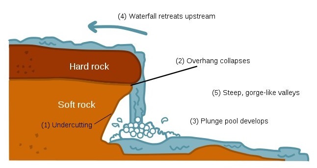
When the river courses over resistant bedrock, erosion happens slowly and is dominated by impacts of water-borne sediment on the rock, while downstream the erosion occurs more rapidly. As the watercourse increases its velocity at the edge of the waterfall, it may pluck material from the riverbed, if the bed is fractured or otherwise more erodible. Hydraulic jets and hydraulic jumps at the toe of a falls can generate large forces to erode the bed, especially when forces are amplified by water-borne sediment. Horseshoe-shaped falls focus the erosion to a central point, also enhancing riverbed change below a waterfalls. Sand and stones carried by the watercourse therefore increase erosion capacity. This causes the waterfall to carve deeper into the bed and to recede upstream. Often over time, the waterfall will recede back to form a canyon or gorge downstream as it recedes upstream, and it will carve deeper into the ridge above it. The rate of retreat for a waterfall can be as high as one-and-a-half metres per year.
Often, the rock stratum just below the more resistant shelf will be of a softer type, meaning that undercutting due to splashback will occur here to form a shallow cave-like formation known as a rock shelter under and behind the waterfall. Eventually, the outcropping, more resistant cap rock will collapse under pressure to add blocks of rock to the base of the waterfall. These blocks of rock are then broken down into smaller boulders by attrition as they collide with each other, and they also erode the base of the waterfall by abrasion, creating a deep plunge pool in the gorge downstream.
Streams can become wider and shallower just above waterfalls due to flowing over the rock shelf, and there is usually a deep area just below the waterfall because of the kinetic energy of the water hitting the bottom. Waterfalls normally form in a rocky area due to erosion. After a long period of being fully formed, the water falling off the ledge will retreat, causing a horizontal pit parallel to the waterfall wall. Eventually, as the pit grows deeper, the waterfall collapses to be replaced by a steeply sloping stretch of river bed. In addition to gradual processes such as erosion, earth movement caused by earthquakes or landslides or volcanoes can cause a differential in land heights which interfere with the natural course of a water flow, and result in waterfalls.
Type of waterfalls
- Ledge waterfall: Water descends vertically over a vertical cliff, maintaining partial contact with the bedrock.
- Block/Sheet: Water descends from a relatively wide stream or river.
- Classical: Ledge waterfalls where fall height is nearly equal to stream width, forming a vertical square shape.
- Curtain: Ledge waterfalls which descend over a height larger than the width of falling water stream.
- Plunge: Fast moving water descends vertically, losing complete contact with the bedrock surface.The contact is typically lost due to horizontal thrust of the water before it falls. It always starts from a narrow stream.
- Punchbowl: Water descends in a constricted form and then spreads out in a wider pool.
- Horsetail: Descending water maintains contact with bedrock most of the time.
- Slide: Water glides down maintaining continuous contact.
- Ribbon: Water descends over a long narrow strip.
- Chute: A large quantity of water forced through a narrow, vertical passage.
- Fan: Water spreads horizontally as it descends while remaining in contact with bedrock.
- Cascade: Water descends a series of rock steps.
- Tiered/Multi-step/Staircase: A series of waterfalls one after another of roughly the same size each with its own sunken plunge pool.
- Cataract: A large, powerful waterfall.
- Segmented: Distinctly separate flows of water form as it descends.
- Frozen: Any waterfall which has some element of ice or snow.
- Moulin: A is a waterfall in a glacier.
Some waterfalls are also distinct in that they do not flow continuously.
Ephemeral waterfalls only flow after a rain or a significant snowmelt
Glacial rock flour
Rock flour, or glacial flour, consists of fine-grained, silt-sized particles of rock, generated by mechanical grinding of bedrock by glacial erosion or by artificial grinding to a similar size. Because the material is very small, it becomes suspended in meltwater making the water appear cloudy, which is sometimes known as glacial milk.
When the sediments enter a river, they turn the river's colour grey, light brown, iridescent blue-green, or milky white. If the river flows into a glacial lake, the lake may appear turquoise in colour as a result. When flows of the flour are extensive, a distinct layer of a different colour flows into the lake and begins to dissipate and settle as the flow extends from the increase in water flow from the glacier during snow melts and heavy rain periods.
Typically, natural rock flour is formed during glacial migration, where the glacier grinds against the sides and bottom of the rock beneath it, but also is produced by freeze-and-thaw action, where the act of water freezing and expanding in cracks helps break up rock formations. Multiple cycles create a greater amount.
Although clay-sized, the flour particles are not clay minerals but typically ground up quartz and feldspar. Rock flour is carried out from the system via meltwater streams, where the particles travel in suspension. Rock flour particles may travel great distances either suspended in water or carried by the wind, in the latter case forming deposits called loess.
Please send me an answers to following questions not later than 3 days after log this geocache:
- What is the cause of a turquoise color of the waterfall and river? (bold header in listing can help you)
- Is difference between rock which formed edge of waterfall and rocks which formed canyon under the bridge?
- What is height and width of canyon under the bridge?
- Can you describe shape and height of waterfall and type of waterfall according to listing? How many cascades can you see?
- Since 25/04/2021 Attach photo of you (your GPS or personal thing) from posted coordinates.
You can log immediately without confirmation. In case of irregularities I will contact you. The answers may not be correct, I am not biting. Photo is main proof you was there, not correct answers.