ES:
La lava es la designación geológica de la roca fundida que sale a la superficie durante las erupciones volcánicas o flujos de lava a través de la chimenea volcánica. Su equivalente subterráneo es el magma que se eleva a través del cráter volcánico o cerca de las fallas tectónicas y grietas litosféricas a la superficie de la tierra, donde posteriormente fluye hacia el medio ambiente en función de su viscosidad. La temperatura de la lava generalmente está en el rango de entre 750 y 1200 °C. Consiste en fases fundidas de rocas, cristales y gases, que cuando entran en contacto con el entorno circundante comienzan a enfriar debido a una temperatura desequilibrada. La lava generalmente interactúa con los dos ambientes más importantes: agua y aire, que afectan su apariencia (textura, estructura) y propiedades resultantes. En contacto con el agua, la lava se endurece rápidamente debido a un enfriamiento rápido, lo que lleva a la formación de una estructura vidriosa en la superficie. Hay almohadillas de lava que forman una gran parte del fondo oceánico en la corteza oceánica. Cuando enfriamiento en el aire, la lava se enfría más lentamente y se forman las estructuras cristalinas dentro de la lava. Dependiendo de el espesor de la lava que se arrastra, la lava puede derretirse de unos minutos a años.
Tu tarea?
En las coordenadas predeterminadas y waipoint, responda las siguientes preguntas:
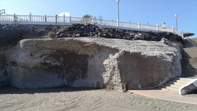
1. Mida o estime la altura de la roca en las coordenadas predeterminadas de acuerdo con "Spoiler 1".
2. En las coordenadas predeterminadas en "Spoiler 2", hay cuatro capas de color en la parte superior izquierda. Cuáles son los colores?
3. En waypoint en la playa en la arena, trate de encontrar una muestra (no un color blanco) similar a "Sample". Describe su color, superficie, textura y tamaño.
4. Puede ver muchos agujeros en la muestra. Intenta pensar qué los causa?
5. Conecte su foto o foto de GPS dispositivo a las coordenadas predeterminadas.
Envíenos sus respuestas a través del perfil, luego puede iniciar sesión - no espere para confirmar la corrección de las respuestas. Si hay algo mal, llamaremos. El silencio significa consentimiento...
EN:
Lava is the geological designation of the molten rock that comes to surface during volcanic eruptions or lava flows through the volcanic chimney. Its underground equivalent is the magma that rises through the volcanic esophagus or near the lithospheric fractures and cracks to the earth's surface, where it subsequently flows into the environment depending on its viscosity. The lava's temperature is usually in the range of between 750 and 1200 °C. It consists of molten phases of rocks, crystals and gases, which when in the contact with the surrounding environment begin to cool due to unbalanced temperature. Lava usually interacts with the two most important environments - water and air, which affect its resulting appearance (texture, structure) and properties. In contact with water, the lava is quickly hardened due to rapid cooling, which results in the formation of a glassy structure on the surface. There are lava pads forming a larger part of the ocean floor on the oceanic crust. With cooling in the air, the lava is cooled more slowly and crystalline structures are formed inside the lava. Depending on the strength of the creeping lava, lava can melt from a few minutes to years.
Your task?
On starting coordinates and waypoint get answers to the following questions:
1. On the starting coordinates according to "Spoiler 1" measure or estimate height the rock.
2. On the starting coordinates according to "Spoiler 2" are at the top left four color layers. What are the colors?
3. On the waypoint on the beach try to find in the sand a sample (no white color) similar to "Sample". Describe its color, surface, texture and size.
4. On the sample seen a lot of holes. Try to think, what caused it?
5. Attach a photo of You or Your GPS device on the starting coordinates.
Your answers send us through the profile, then You can log - do not wait for confirmation of the correctness of answers. If something goes wrong, We'll call. Silence means consent...
DE:
Die Lava ist Bezeichnung des geschmolzenen Gebirgssteins, der während Vulkanerruptionen die Oberfläche erreicht, oder eines Lavaergusses der durch den Vulkanschlot strömt. Ihr unterirdisches Ekvivalent heißt Magma, das durch den Vulkankrater oder in der Umgebung von Litosphärischen Brüchen und Rissen hinaussteigt, wo es darauffolgend in die Umgebung fließt abhängig von der Viskosität. Die Lava-Temperatur liegt gewönlich zwischen 750 und 1200 °C. Sie besteht aus geschmolzenen Gesteinphasen, Kristallen und Gäsen, die bei Kontakt mit der Umgebung durch den Einfluss der unausgeglichenen Temperatur abzukühlen beginnen. Die Lava gerät gewönlich in eine Interaktion mit den 2 wichtigsten Umgebungen – Wasser und Luft, die ihr Endaussehen (Textur, Struktur) beinflüssen. Bei Kontakt mit Wasser kommt es zur schnellen Erstarrung der Lava, dass zur Entstehung einer Glasstruktur an der Oberfläche führt. Es entsteht Kissenlava, die einen größeren Teil des Meeresbodens gestaltet. Während der Abkühlung durch die Luft kommt es zu allmählichen Kühlung der Lava und zum Entstand von Kristallstrukturen. Abhängig von der Kraft der erstarrenden Lava, kann Lava entweder einige Minuten oder ganze Jahre erstarren.
Was ist eure Aufgabe?
Auf den Ausgangskoordinaten und dem Waypoint stellt Antworten auf folgende Fragen fest:
1. Auf den Ausgangskoordinaten gemäß „Spoiler 1“ schätzt oder messt die Höhe des Felsens.
2. Auf den Ausgangskoordinaten gemäß „Spoiler 2“ sind oben vier Farbschichten. Welche Farben haben die?
3. Versucht auf dem Waypoint am Strand im Sand eine Probe (nicht weißer Farbe) ähnlich dem „Sample“ zu finden. Beschreibt die Farbe, Oberfläche, Textur und Größe.
4. Ihr könnt viele Löcher auf der Probe sehen. Denkt darüber nach, was die verursachen konnte?
5. Schließt ein Foto von sich selbst oder dem GPS-Gerät auf den Ausgangskoordinaten an.
Sendet eure Antworten über eure Profile, nachher könnt ihr euch einloggen – Ihr müsst nicht auf eine Bestätigung der Richtigkeit eurer Fragen warten. Sollte etwas falsch sein werden wir uns melden. Schweigen bedeutet Zustimmung...
CZ:
Láva je geologické označení roztavené horniny, která se dostává na povrch během sopečných erupcí, či lávových výlevů proudící sopečným komínem. Jejím podzemním ekvivalentem je magma, které vystupuje sopečným jícnem nebo v okolí litosférických zlomů a prasklin na zemský povrch, kde se následně rozlévá do okolí v závislosti na své viskozitě. Teplota lávy je obvykle v rozmezí 750 až 1200 °C. Je tvořena roztavenými fázemi hornin, krystaly a plyny, které při kontaktu s okolním prostředím začínají vlivem nevyvážené teploty chladnout. Láva se obvykle dostává do vzájemné interakce se dvěma nejdůležitějšími prostředími - vodou a vzduchem, které ovlivňují její výsledný vzhled (texturu, strukturu) a vlastnosti. Při kontaktu s vodou dochází k rychlému ztuhnutí lávy, což vede k vytvoření sklovité struktury na povrchu. Dochází ke vzniku lávových polštářků, kterými je tvořena větší část oceánského dna na oceánské kůře. Při ochlazování vzduchem dochází k pozvolnějšímu ochlazování lávy a k tvorbě krystalických struktur. V závislosti na mocnosti tuhnoucí lávy, může láva tuhnout od několika minut až po roky.
Váš úkol?
Na výchozích souřadnicích a waipointu zjistěte odpovědi na následující otázky:
1. Na výchozích souřadnicích podle "Spoiler 1" změřte nebo odhadněte výšku skály.
2. Na výchozích souřadnicích podle "Spoiler 2" jsou vlevo nahoře čtyři barevné vrstvy. Jaké jsou barvy?
3. Na waypointu na pláži se pokuste najít v písku vzorek (ne bílé barvy) podobný jako „Sample“. Popište jeho barvu, povrch, texturu a velikost.
4. Na vzorku můžete vidět mnoho děr. Zkuste se zamyslet, co je způsobilo?
5. Připojte fotku sebe nebo GPS přístroje na výchozích souřadnicích.
Vaše odpovědi nám zašlete přes profil, následně se můžete zalogovat - nemusíte čekat na potvrzení správnosti odpovědí. Pokud bude něco špatně, ozveme se. Mlčení znamená souhlas...
Za překlad do cizích jazyků patří velké díky "Celonkovci".
Martina a Radek