This cache was nominated in the 2018 Victorian Cache of the Year Awards (Best 'Other' Cache).
At the listed coordinates you will find a railway cutting, exposing layers of sedimentary rock. These rocks are estimated to be 430 million years old, dating from the Silurian Period. At that time, Australia was still part of the supercontinent Gondwana, with much of the east coast underwater.
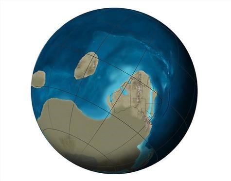

Life was slowly making the major move to land. Plants were colonising the landscape, making it habitable for other life forms as they came ashore.
Layers of sediment were deposited in the water, compacting to form rock over time. Each layer was thus like a ring in a tree trunk, however rather than taking a year to form, each sedimentary rock layer can be estimated, on average, to have taken 13,000 years.
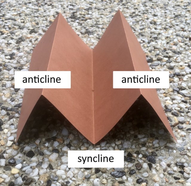
Tectonic plate movements continue to create the changing face of the Earth. Continents break apart and reform, mountains arise and valleys appear. Around 390 million years ago a cycle of plate movements, known as the Tabberabberan orogeny, affected most of Victoria and, at the time, produced a major mountain range, called the Tabberabberan Highlands. Uplift associated with this event caused the sea to retreat to the east, so that all marine sedimentation ceased in Victoria.
The Tabberabberan orogeny created concertina folds across Victoria. Mountain folds are known as anticlines, valley folds are called synclines.
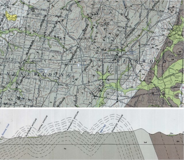
The folds trend approximately 20 degrees east of north with a wavelength of around 4km in the Heatherdale area. Local fold lines are the Blackburn anticline, Tunstall syncline, Warrandyte anticline, Mitcham syncline and Ringwood anticline. Sedimentary rock layers, which were originally horizontal, thus follow the lines of folding and can be observed in exposed outcrops, such as the railway cutting where you now stand.
Logging Requirements
To log this EarthCache, answer the following questions and then post your answers to Mister Doctor.
★ Question 1. Your caching name and the name of this cache.
★ Question 2. Observe the upward slope of the layers. Are they sloping up in the direction of Mitcham or Heatherdale stations?
★ Question 3. Is this upward slope from syncline-to-anticline, or anticline-to-syncline?
★ Question 4. Find the two electrical masts in the cutting below numbered H739 and H741. Count the number of layers on the cutting wall that fall between them.
★ Question 5. If each layer represents on average 13,000 years, how many years are represented by the number of layers you counted in Question 4?
You are free to log this cache as soon as the questions are answered, but if your answers aren't posted within a week your log may be deleted.
***CONGRATULATIONS to Geo_Seek on the FTF***
🕋 A Doctor Who Connection 🕋
As astutely noted by quiet1_au and legomcnelly, the Silurians also featured in Doctor Who as a race of reptile-like humanoids dating from the Silurian Period 🐊
🕰 A Slice of Time 🕰
A thoughtful reflection by NinjaTortoise: ”every time a train travels between those two stanchions it is covering [a vast number of] years. That reminds me of the passage from the Venerable Bede: "The sparrow, flying in at one door and immediately out at another, whilst he is within, is safe from the wintry tempest; but after a short space of fair weather, he immediately vanishes out of your sight, passing from winter into winter again.” 🐦
For a related Earthcache, and a view of the other side of the Ringwood anticline, I’d recommend GC7VPPD The Rocky Beauty Show by Byker
Sources
● Agriculture Victoria - Victorian Resources Online - Tabberabberan Orogeny
● Geological Survey of Victoria. Ringwood 1:63 360 geological map
● Geological Survey of Victoria. Explanatory notes on the Ringwood 1:63 360 geological map
● Geosciences Australia - Geodynamic Synthesis of the Phanerozoic of Eastern Australia and Implications for Metallogeny
● Lebork IG 1 Borehole - Drill Core through Silurian Deposits
● Melbourne Museum - 600 Million Years - Silurian
● Wikipedia - Silurian