The container IS NOT at the posted coordinates. But they are available here.
This geoart series will be somewhat different from others. Because of our interest in the Oklahoma Land Run we've compiled quite a bit of history from the Oklahoma Historical society. It's loosely laid out in a chronological order through the series from the O to the L finally to the R. The Oklahoma outline portion of the art will be general history questions and state facts. We hope you enjoy the history lesson and journey.
Many of the containers are preforms, some are not. Most are up off the ground, some are not. Some have parking pull offs, some do not. Some are on paved roads, many are not. Please use common sense during periods of inclement weather.
One part of the territory, "Old Greer County," was added by judicial decree. The area bounded by the North Fork of the Red River, the Red River, and the 100th Meridian had long been claimed by Texas, which alleged that the North Fork, not the Prairie Dog Town Fork, was the true source of the Red River. In the case of United States v. Texas (1896) the U.S. Supreme Court declared that the former rather than the latter was the true source and attached what would become Greer County to Oklahoma.
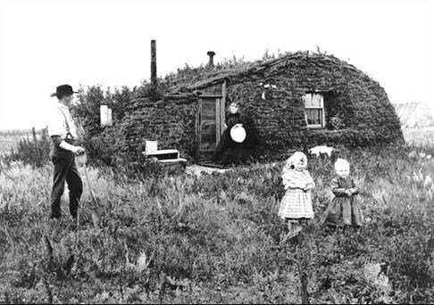
This piecemeal, crazy-quilt method of evolving a territory initially through horse races created some problems that took years to solve. First, there was the problem of conflicting claims over land. The only topographically flat part of Oklahoma is the High Plains of the Panhandle. Most of the western half of the state consists of a rolling plains with timbered bottom lands. Some participants staked their claims only to discover another claimant on the same 160-acre claim but on the other side of a hill or across the creek beyond woods that served as a blind between the settlers. Other contests resulted from the claims of "sooners," those who entered the lands illegally prior to the official openings. Government officials after the run of 1889 tried to prevent this practice in the Cherokee Outlet Opening by requiring participants to register at booths along the boundary only a few days prior to the legal opening. Some contests led to violence while quarreling after staking the claim, or later. William L. Couch, a leader of the Boomer Movement, died of a gunshot wound inflicted by a rival contestant. Ira N. Terrill, a member of the first territorial legislature, shot and killed George M. Embrey over a land contest in Stillwater. The problem finally goaded the Department of the Interior into appointing William F. Harn and John W. Scothorn in 1891 as special agents to investigate and indict sooners for the crime of perjury.
Continued in Chapter 26.
Material and photos courtesy of: Oklahoma Historical Society Research Center
N 35 17.974, W 096 31.746