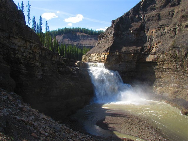
This viewpoint provides you an excellent glimpse of the amazing and rarely seen Tapestry Falls. These falls, which are a part of the South Ram River, launch water down a steep rocky precipice. While you are enjoying the roar of Tapestry Falls, look down and answers the questions below!
Tapestry Falls:
Ever Wonder How a Waterfall Forms?
Waterfall formation is based around the basic principle that there is a watercourse traversing over different layers of rock each with different rates of erosion. In other words, you have a river or stream flowing over hard rock (where erosion is slow) and also flowing over soft rock (where erosion is more rapid).
Over time, the soft rock is further cut into by the water ultimately making the watercourse steeper beyond the hard rock layer. This steepening effect also accelerates erosion as the influence of gravity on the water increases the water's speed (thanks to the increasing slope as a result of the accelerated erosion).Eventually, the watercourse steepens until it's either nearly vertical or completely vertical. At this point, you have a bon-a-fide waterfall!
But the story doesn't end there!
With the watercourse continuing to cut into the softer rock, the waterfall gets taller, the plunge pool (where the waterfall lands) gets deeper, and the soft rock directly beneath the hard rock gets undercut. This can lead to the hard rock layer actually overhanging.
As the undercutting continues, eventually the overhanging hard rock gets unstable and collapses into the base of the waterfall. The net result of this action is that the waterfall retreats further upstream to the remaining lip of the hard rock layer. The undercutting still continues until you run out of the hard rock layer. At that point, the watercourse will probably go back to being a stream or rapid.
To Log this Earthcache, Please Answer the Following (email answers to cache owner):
1) Examine the rocky cliff of the gorge you see directly behind the falls from this viewpoint. How many distinct rock layers can you count? Do the layers have different appearances or physical features?
2) Look carefully at the rock just above and below Tapestry Falls. Approximately how tall do you think the falls are? Approximately how thick is the hard rock layer? How about the soft rock layer?
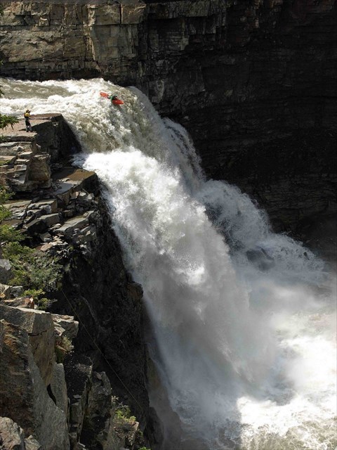
Fun Fact - Jakub Nemac was the First to Run the Falls in a Kayak in 2009: