An earth cache dedicated to the lasting effects of the 14 November 2016 “Kaikoura” earthquake, on the Wellington Quays and the Wellington CBD (Central Business District).

The island nation of New Zealand sits on the "Pacific Ring of Fire", the geographic border of the Pacific tectonic plate.
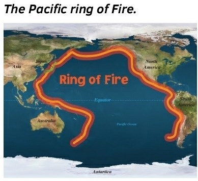
In New Zealand's zone, the major Alpine faultline and the Kermadec trench mark the edges where the Pacific plate and the Australian plates interface. The constant annual movement of each plate interface results in the accumulated storage of "energy", ultimately released as earthquakes. Frequent earthquakes, of smaller magnitudes, release this stored energy in a less destructive manner. Over time, if larger amounts of energy are accumulated and not regularly released, a larger more severe "earthquake" event will occur.

On the 14 November 2016, two minutes after midnight [00:02:56 NZDT], a series of shallow earthquakes struck New Zealand, centered near Culverden, Marlborough (top NE of the South Island NZ). Officially recorded as Culverden, the 7.8 magnitude earthquake is frequently referred to as the “Kaikoura” earthquake.

The earthquake started at about 15 kilometres (9 mi) north-east of Culverden and 60 kilometres (37 mi) south-west of the tourist town of Kaikoura and at a depth of approximately 15 kilometres (9 mi). The complex sequence of ruptures lasted for about two minutes. Ruptures occurred on multiple faults and the earthquake has been described as the "most complex earthquake ever studied". The cumulative magnitude of the ruptures was 7.8, with the largest amount of that energy released far to the north of the epicentre. [Wikipedia]


The largest amount of energy released did not occur at the epicentre, rather 100 km (62 mi) to the north near Seddon. Initial field surveys indicated ruptures on at least six faults while more detailed studies confirmed ruptures on twenty-one faults. This is considered a world record for the greatest number of faults to rupture in a single earthquake event. The earthquake was assessed as the 'most complex earthquake ever studied' and prompted the reassessment of a number of assumptions about earthquake processes.[Wikipedia]
As a result, Cape Campbell, at the north-eastern tip of the South Island, moved to the north-northeast by more than two metres – putting it that much closer to the North Island – and rose almost one metre. Kaikoura moved to the northeast by nearly one metre, and rose seventy centimetres. The east coast of the North Island moved west by up to five centimetres, and the Wellington region moved two to six centimetres to the north. Christchurch moved two centimetres to the south. [Wikipedia]
The full wikipedia article on the “2016 Kaikoura Earthquake”: link
Sadly two lives were lost near the epicentre. A man was crushed and died when the historic Elms Farm homestead near Kaikoura collapsed. Two other people were rescued from the rubble of the house, including the man's 100-year-old mother. A woman died in a log house that was damaged at Mount Lyford. Early reports said her cause of death was a heart attack, but an autopsy later indicated it was a head injury suffered during the earthquake. [Wikipedia]
This cache is dedicated to the ongoing impact and visible effects on the skyline and urban landscape of Wellington city. The earthquake and main aftershocks struck late on a Sunday evening, technically still the weekend, a time when the Wellington Quays and Central Business District were predominantly vacant. Thankfully no lives were directly lost in Wellington, directly attributed to the earthquake. Had the quake struck later, during the working day, the impact on human life could have been much more significant.
The wikipedia list of majorNew Zealand Earthquakes: link
The coordinates take you to a public accessible area, on Wellington's working wharf area. The “very new” carpark East of gz marks the former footprint of the Statistics New Zealand building, irrepairably damaged in the November 2016 quake. A carpark slightly NW marks the former footprint of the New Zealand Rugby Union Building, now demolished, structurally damaged in a previous quake. Further East from the Stats NZ footprint vacant land marks the former site of addition demolished wharf sheds. Further East, a wharf lies damaged and unused. Note the odd shape of the historic Maritime House, South East of gz. This building was previous surrounded by multiple wharf sheds and structures. South West of gz, behind Custom House, is the vacant land from the demolition of Sea Works house and a large adjacent wharf shed, formerly used by Freightways. By all accounts this vacant land will become another “very new” carpark. Further South East of the gz stands the now vacant building, formerly tenanted by BNZ (Bank of New Zealand). Some distance North of the gz, the elaborately paint wharf shed, previously used as the Wellington Cruiseship terminal is now being demolished. Likely to be completely gone before this cache is published.
The following image shows a circa 2010 view above gz, with The Custom House under construction. A current (at time of cache publication) image of the same location, circa August 2018 will show a significantly reduced number of building.

As visitors wander through parts of the Wellington CBD they will also notice the odd vacant piece of land, some utilised as ground level carparks. Many if theses vacant lots are the result of further demolitions, either as a direct result of earthquake damage or building considered below new earthquake standards, and uneconomic to strengthen. One of the most striking examples is the vacant “hole” left by the recent demolition of the NZ Defence Force’s Freyberg House, on the Cnr of Aitken and Mulgrave Streets, Thorndon.
To log this cache, you are simply required to answer the following questions, message them to the CO, and wait for permission to log:
1) Name the official epicentre for the earthquake referenced in this cache.
2) List the top three magnitude events, in sequence, that occurred after midnight 14th November 2016 (affecting New Zealand).
3) Name or describe the surface material at gz, amongst the seating. (proof of visit)
4) Name the two plates which meet in New Zealand..
For extra kudos (optional), cachers can opt to post a recent photo of the location and attach it to your log. Hint: any optional photo could include a local deconstructed building site or include structures located at the gz (i.e. buildings still standing).
A limited number of public carparks are available along The Boulevard, the rest of the area is the operational Wellington wharf, operated by Centre Port Limited. Please use the Stadium concourse or the traffic lights if crossing the Quay. Multiple public transport options exist from the adjacent Wellington railway station and bus terminus.
Update: 22.Oct.2018: There are 2hr short stay carparks outside NZ Customs House, technically free for short term use. Visitors during normal business hours (week days) can get a very good espresso coffee and food at the wharf food van 20m North of gz.